
Last time, I wrote about my adventures in the High Sierras of California. Here’s the rest of the trip – including volcanoes in the Cascade Range!

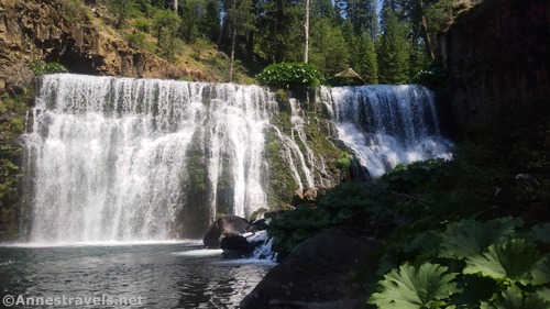
From Yosemite, we drove north through Sacramento and Redding and up to McCloud Falls. I’d heard good things about them from a friend who grew up in the area. What made them appealing to me was that you’re allowed to swim below the falls – and when it’s 111F in the valley, swimming feels mighty good!
I’d hoped to visit the Trinity Alps (more scenery that is given rave reviews by friends), but it was just too hot. The area was receiving record-breaking temperatures. Plus the views were hazy due to a nearby fire. It just wasn’t a good combination. So we drove to the coast with the intent of taking in the sights on the beaches in Oregon.

However, I got sidetracked by a memory of Fern Canyon in Redwood National Park (actually Prairie Creek Redwoods State Park; they’re jointly managed). Come to find I’d missed the permit deadline for parking at the Fern Canyon trailhead, but not to worry! There are a couple of longer trails that also lead to Fern Canyon and don’t require a permit. We struck off on one of them, pretty much oblivious to the beauty we were about to experience. A hike through the redwoods took us to the beach, where we saw seals playing in the water.

After a peaceful beach walk, we trekked into Fern Canyon. It’s a beautiful place, but too crowded by my standards. If I do it again, I’ll have to arrive very early, or at least not in the middle of the day.

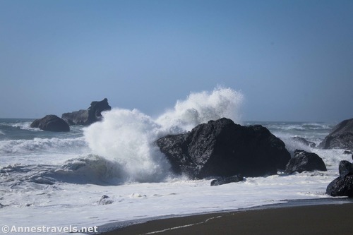
From there, we hiked back up the coast via the Coastal Trail. This was a peaceful stroll through seaside meadows past three tall waterfalls – so serene. Before we headed back up to the van, we went down the beach to see the nearby seastacks (it was very misty early and by the time we came back, there was sunshine). The waves were crazy high, smacking against the stacks in spray 50 or more feet in the air. Incredible! And the entire day was only (only!) 15 miles of hiking!
We finally did enter Oregon the next day and took a recommended hike along the Oregon Coastal Trail in Samuel H. Boardman State Park. I would definitely do it differently if I hiked the route again, but we eventually found some good views. Highlights included the Indian Sands, hiking across the tallest (2nd tallest?) highway bridge in Oregon, and China Beach.

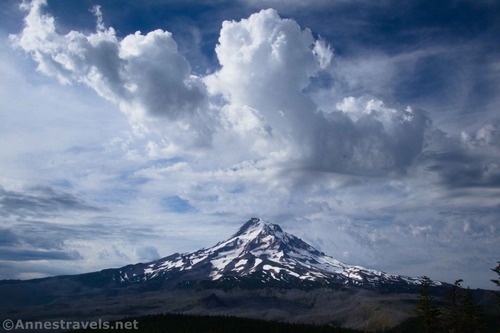
Not all of my group is in love with beach walks, and we’d done the southern Oregon coast pretty well in 2016, so we left the coast altogether and drove up to Mt. Hood. Our first adventure was up to McNeil Point. Some of you will remember that I took the Mazama Trail up to McNeil Point in 2016, but it was so foggy, the views were a complete loss. This time, the views were out of this world!
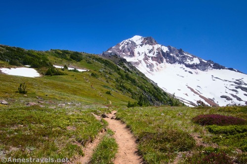
Every time we go to Mt. Hood, I consider going to the Zigzag Overlook and Paradise Park, and every time, we never quite end up doing it… until now. To be honest, the park wasn’t that amazing (we were a little early for wildflowers), but the two social trails leading up the side of Mt. Hood were beyond spectacular. The sheer ruggedness of the mountain from up here – plus the views of ZigZag Canyon – took my breath away over and over. I have a new favorite hike in northern Oregon!

Also in 2016, we took a hike up Gnarl Ridge. Elk Meadow was pretty, but by the time we arrived on the ridge, the mountain was socked in. We all wondered what the hike would look like if we could see more than clouds where the mountain was supposed to be! It turned out to be the low point of our adventures on Mt. Hood this time; very steep, very hot (Portland was over 100F that day), and with views that simply didn’t live up to what we’d already seen on that trip. Oh well – we know what the mountain looks like from this angle now!

That night, we drove around Mt. Hood in the fading light on the crazy network of logging roads up to the Vista Ridge Trailhead (sunset on Mt. Hood – and also through the trees to Mt. Adams and Mt. St. Helens – was so fun). I’ve tried hiking to Owl Point twice before (once in 2010 and again in 2016), and every time, we’re foiled somehow. This time, there were some clouds… but they more or less parted for us. Yay!
We visited the Rockpile, too, before heading off-trail to Red Hill. Of the three viewpoints, Red Hill was definitely my favorite in terms of views. It has a “magnificent factor” that the others miss somehow.

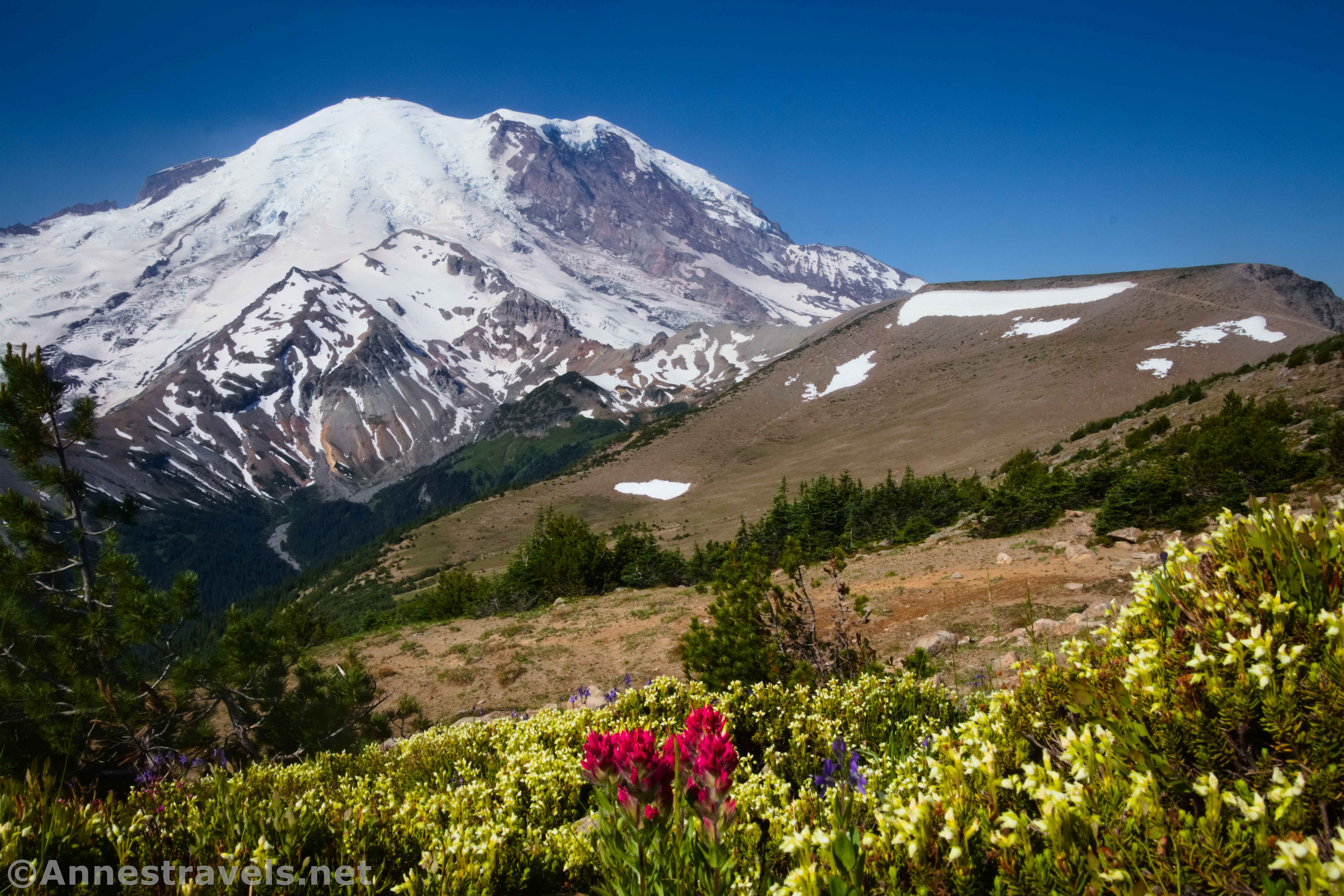
As if we hadn’t seen enough volcanic activity at one of the volcanoes in the Cascade Range, we drove up to Mt. Rainier National Park. There is only one convenient road between the two, and we arrived only to find the road washed out (not what you want to discover when you’re on a tight timeclock and you’ve already invested several hours in getting to the closure). I’m sure they’ll fix it eventually, but in an attempt to not drive most of the next day on an alternate route (back down to Hood River and over to I-5, anyone?) we found some dirt roads (so thankful for GPSes, though this workaround happened to be on my AAA map). It was a late night and an early morning, but we still got up to Sunrise and climbed the three Burroughs Mountains. Jaw-dropping views of Mt. Rainier for miles on end from alpine meadows… this is the kind of hike I love!

The next day, we set out for Glacier Basin just because we happened to be in the area and my sources gave it high ratings. “Let’s see Emmons Glacier Viewpoint first,” we said. But of course we went beyond the “Trail Not Maintained Beyond this Point” sign up to a better view. Then on our way down, we saw an old road striking into the woods and decided to follow it. Suffice to say that we followed that until it petered out, eventually accessing the Climber’s Trail up toward Steamboat Prow. The rangers who passed us were a little surprised to see day hikers, but they all knew about the old road. “Ranger Sam has plans for that,” they said. From the top of the ridge, the views of the Emmons Glacier were even better. We never did make it into Glacier Basin, but the views we saw were well worth the extreme effort to get there!

Our final morning in the park, we hopped-to and hiked up to Glacier Basin (again!) This is the second route for hikers who want to ascend to Camp Schurman or as an attempt to summit Mt. Rainier (the first was the Climbers Trail we took the day before). They all leave their shoes under a specific rock near where the snowfields begin, making for a colorful and unique discovery if you happen to look in the right place. And since you’re so near the Inter Glacier, it’s a gorgeous little valley even if we had no interest (or time!) in going very high.

I intentionally saved a day at the end of the trip so that we could take a single hike on our way home: the Blue Lakes in Colorado. A friend had raved about the area to me, but there are plans for a permit system that will drastically limit hikers starting in 2025. (From what I can see, they need a permit system for camping much worse than for day hikers – the trails aren’t overused, but the camping area is badly trampled). Given the opportunity, I did really want to see the lakes, and I’m a professional disliker of permit systems in general and especially permits that are highly sought-after (the exclusivity of “I got a permit and you didn’t” attitude of other hikers drives me nuts, let alone the uncertainty of trying to snag one in the first place… and do I really know where I’ll be 6 months in advance?). So up to the trailhead we did go, and then up to the Blue Lakes we did hike! By some miracle, it didn’t monsoon that day, so we were able to climb all of the way up to the saddle, where we could see mountaineers ascending the 14er Mt. Sneffles.

That was a bang-up way to end our hiking adventures! There are so many awesome trails in this list… I can’t wait to share them all with you as full posts over the next many months!

Today’s Featured Product!
More than 85 hikes are featured in this guide to day hiking on and around Mt. Hood. The guide includes so many helpful features, including color photographs, GPS coordinates, child or dog-friendly trails, and much more. Buy your copy here!


Pingback: 81 Miles in the High Sierras! – Anne's Travels