Zone 5
Great Plains (Iowa, North Dakota, South Dakota, Nebraska, Kansas, Oklahoma)
North Dakota
I Trail to PS Trail to T Trail
5.0 mile loop 864ft. elevation gain; Moderate
The names themselves confuse me, but the I Trail to PS Trail to T Trail offers hikers and bikers a chance to explore badlands, ridges, and views of the Little Missouri River. It may be difficult to tell exactly where the trail goes due to cattle trails, so make sure you take a good map or trail app with you.
South Dakota

Notch Trail
1.2 miles out & back; 150ft. elevation gain; Moderately Strenuous
The hike up to the Notch is half of the excitement of the trail – the other half is the great views of the Badlands. It’s not recommended for people with a fear of heights, though I’ve never had an issue with the drop-offs.
Iowa

Clive Greenbelt Trail: University Park to Campbell
7.3 miles out & back; 68ft. elevation gain; Easy
The Clive Greenbelt Trail between University Park and Campbell is an easy, wide, paved trail that keeps mud at bay. If you’re looking for a longer hike or bike, the trail extends in both directions – on the Campbell end, all the way down to Clive Lake.
Nebraska

Smith Falls Trails
1.1 miles out & back; 49ft. elevation gain; Easy
The trail to Smith Falls is an easy stroll. Go before the leaves come out for better views of the falls. Ice on the waterfall adds to the experience.
Kansas
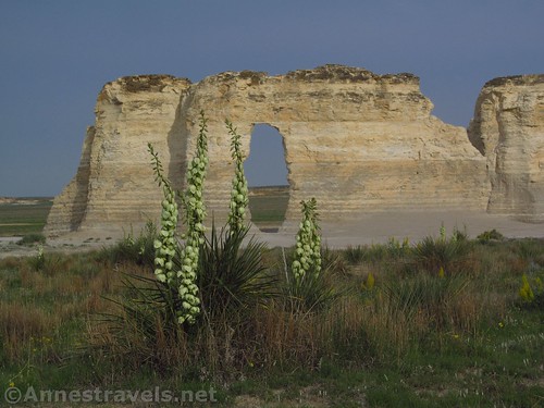
Monument Rocks
Varies; Varies; Easy
There are no official trails around the Monument Rocks, but they’re well worth wandering around to see. Keep your eyes open for arches and for wildflowers in the spring.
Oklahoma

Crab Eyes Trail
4.0 miles out & back; 406ft. elevation gain; Easy
Avoid some of the summer hazards of the Wichita Mountains by taking the trail up Crab Eyes in the spring. Rocks galore make the trek up the peak more interesting.
Zone 6
Great Lakes States (New York, Ohio, Michigan, Wisconsin, Minnesota, Indiana, Illinois)
Minnesota

Dakota Trails Loop
3.9 mile loop; 1,033ft. elevation gain; Moderate
The Dakota Trails Loop in Whitewater State Park offers some good bluff views, especially before the leaves come out on the trees. The creek adds to the beauty and ambience.
Wisconsin
Bairds Creek Orange Loop
8.7 mile loop; 581ft. elevation gain; Moderately Strenuous
The Bairds Creek Orange Loop seems to do its best to cover as much ground as possible. Traveling along a creek for much of its length, the path has the advantage of traveling up one side of the stream and down the other.
Illinois
Morton Arboretum Loop
4.5 mile double loop; 176ft. elevation gain; Easy to Moderate
Easy trails and beautiful grounds are featured on the Morton Arboretum Loop. Various trees are labeled, so you can have a cross-cultural botany lesson as you hike. Trails crisscross the main loop, so you can shorten the trail as you wish.
Indiana

Camp Creek and Fall Creek Trails
2.7 mile lollipop loop; 124ft. elevation gain; Easy
The Camp Creek and Fall Creek Trails form a loop of contrasts and varied difficulty. Steep hills and gentle grades, forests and streams, a lake and bridges all make the trail memorable.
Michigan
Marl Lake Trail System
5.0 mile loop; 272ft. elevation gain; Easy to Moderate
About half of the Marl Lake Trail System is along Marl Lake, making the trail quite pretty. Various trails short-cut the hike if you want it to be shorter.
Ohio

Deer Lick Cave Loop
3.7 mile loop; 484ft. elevation gain; Moderate
The Deer Lick Cave Loop is almost entirely forested, but the rolling hills and stream keep it pretty. Be sure to also check out the cave.
New York
Deckertown Falls
0.25 miles out & back; 200ft. elevation gain; Easy to Moderate
Situated close enough to Watkins Glen and Montour Falls to be almost completely overlooked, Deckertown Falls is a beautiful example of the Finger Lake’s waterfalls. Three main falls tumble down an enclosed gorge in beautiful succession.


