To be perfectly honest, I’m not sure if the trail I took from Skyland to the Basalt Overlook (just off the Tahoe Rim Trail) is all that official. But I found it on AllTrails, so that counts for something, right? At any rate, there is a small pulloff for a parking area and no signs telling me to “trespass not.” And with views this spectacular, plus a pleasant forest walk, it’s a great way to enjoy Lake Tahoe!
Quick Stats

My route up to the Basalt Overlook began in the Skyland neighborhood, a vacation cottage community above the western side of Lake Tahoe. Other than the confusing roads (it’s a real maze up here!), it was pretty quiet, and no one looked at us weird. The trailhead is at the very top of the hill; it’s just what appears to be a driveway heading up into the hills beyond. The parking area is little more than a wide spot of dirt on the other side of the road just uphill of the trailhead – you might be able to squeeze in three cars if they were compact. Please don’t park anywhere except this dirt area; the rest of the driveways, etc., are private.

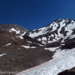
Hike up the long, paved driveway as it passes a house or two and then becomes gravel. At the end of the first switchback, continue straight on the trail instead of following the road to the right up toward the water tower. The trail continues straight for a short distance before turning sharply right. It quickly becomes somewhat brushy, but there’s no question that it’s a trail. Be sure to look up and to the left – you can see the lower part of the basalt columns (below the overlook) high above you (not that it’s anything like a straight shot to get up there!)

There are also peek-a-boo views to Lake Tahoe.

After entering the forest, the trail is less brushy as it rises along the hillside. This was a fairly pleasant hike, if steep. There were a few trees to climb over, but nothing crazy.

After a mile, the trail suddenly intersects the Tahoe Rim Trail – there are no signs, so you’ll just have to know to turn left (and remember where you turned so that you can take it on the way back!)

The trail continues to climb another 0.2 miles to an open area with a social trail through the bushes on the left. Turn slightly downhill through the bushes (it’s a well-enough defined trail, but it’s not marked so you’ll have to watch for the turnoff – it’s at the point where the Tahoe Rim Trail swings right).

A tenth of a mile will bring you to the first overlook – to get here, turn right on one of the multiple social paths on top of the Basalt Overlook to descend and then ascend up a rocky scramble to the top of the viewpoint. Use care, as the path is slightly slippery (and not all of the rocks are stable).

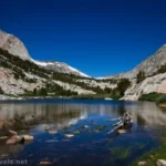
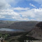
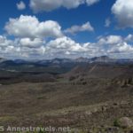
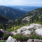
The views from here are spectacular. Be sure to look right up the valley as well as out to Lake Tahoe.

To get to the second overlook, retrace your steps back up to the main social trail (near where you turned right) and turn right to effectively take the social trail straight out to the end of the point.

The views from here are more of Lake Tahoe and the mountains across the way. We were surprised just how much this view reminded us of Lake George in the Adirondacks.

When you’ve enjoyed the view, feel free to explore more of the Tahoe Rim Trail before descending the way you came back to the trailhead!

Round Trip Trail Length: I went 2.6 miles
Elevation Gain: 934ft. (6,437ft. to 7,094ft.)
Facilities: None
Fees: None

Trail Notes: Be sure to respect the property rights and privacy of the neighbors – it’s altogether possible that “no parking” signs might go up if you or others are annoying. Bicycles are allowed (and often used) on the Tahoe Rim Trail, so be wary of wheeled adventurers.

Trail 
![]()
![]()
Road ![]()
Signs ![]()
![]()
![]()
Scenery ![]()
Would I go 100 miles out of my way for this? ![]()
Overall Rating: 
![]()

GPS Coordinates for the Basalt Overlook
Parking area: 39.1153050°, -120.1635500° (39°06.91830′, -120°09.81300′ / 39°06’55.0980″, -120°09’48.7800″) (6,436ft.) (0.0)
Tahoe Rim Trail Junction: 39.1197980°, -120.1704980° (39°07.18788′, -120°10.22988′ / 39°07’11.2728″, -120°10’13.7928″) (7,143ft.) (1.02)
Overlook Junction: 39.1178980°, -120.1695170° (39°07.07388′, -120°10.17102′ / 39°07’04.4328″, -120°10’10.2612″) (7,209ft.) (1.19)

Basalt Overlook: 39.1172110°, -120.1693290° (39°07.03266′, -120°10.15974′ / 39°07’01.9596″, -120°10’09.5844″) (7,171ft.) (1.26)
2nd Basalt Overlook: 39.1174900°, -120.1686400° (39°07.04940′, -120°10.11840′ / 39°07’02.9640″, -120°10’07.1040″) (7,181ft.) (1.40)
End (TH): 39.1153060°, -120.1636220° (39°06.91836′, -120°09.81732′ / 39°06’55.1016″, -120°09’49.0392″) (6,439ft.) (2.61)

The gpx file for the Basalt Overlook can be downloaded – please note that this and the GPS Coordinates are for reference only and should not be used as a sole resource when hiking this trail.
Download GPX File size: 33.3 KB Downloaded 56 times
(Note: I do my best to ensure that all downloads, the webpage, etc. are virus-free and accurate; however, I cannot be held responsible for any damage that might result, including but not limited to loss of data, damages to hardware, harm to users, from use of files, information, etc. from this website. Thanks!)

Getting to the Basalt Overlook
From I-80, take Exit 185 for CA-89S. Make sure you continue on CA-89S through two traffic circles (take the 3rd exit and then the 1st exit). Another traffic circle will appear after 13.3 miles; take the 1st exit to continue on CA-89S; repeat taking the 1st exit to CA-89S 0.3 miles later in yet another traffic circle. Drive 3.7 miles; turn right onto Elizabeth Drive. The road will go steeply uphill into a neighborhood of vacation cabins. After 0.3 miles, the road turns slightly right and becomes Leota Way; the “parking area” (little more than a wide spot in the road with enough dirt between the pavement and the trees on the steep hillside for about three cars) will be on the right almost at the top of the hill. A long driveway will be on the left; this is the beginning of the trail.

From where CA-89 meets US-50 near South Lake Tahoe, turn north on CA-89 for 23 miles. Turn left onto Elizabeth Drive. The road will go steeply uphill into a neighborhood of vacation cabins. After 0.3 miles, the road turns slightly right and becomes Leota Way; the “parking area” (little more than a wide spot in the road with enough dirt between the pavement and the trees on the steep hillside for about three cars) will be on the right almost at the top of the hill. A long driveway will be on the left; this is the beginning of the trail.

Today’s Featured Product!
Explore both the rich history of Lake Tahoe and its spectacular scenery with this guidebook. Short hikes and longer adventures take you to important – or at least interesting – places of historic fascination. Buy your copy here!