
Goat Lake was probably the most beautiful lake I saw in the Sawtooth Mountains. Sawtooth Lake was also very nice (especially from the far end), but it lacked the deep blue color and sheer cliffs of its nearby counterpart. That doesn’t mean that Goat Lake is easy to access (there is a trail most of the way up to it!), just that it’s worth the effort (and the pretty views along the way) to visit!
Quick Stats
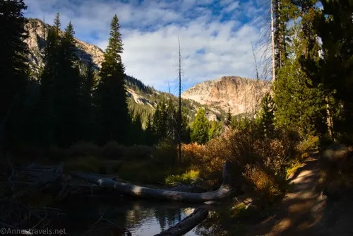
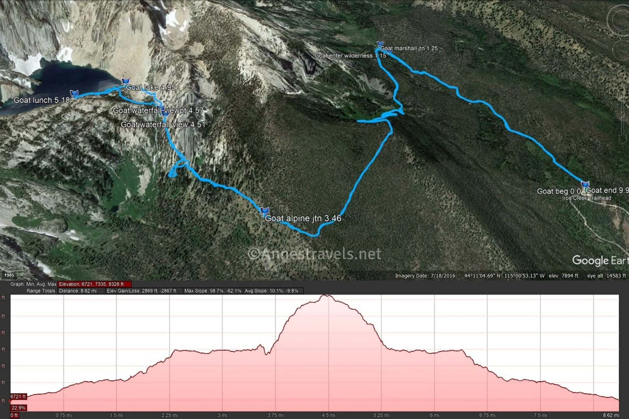
The path to Goat Lake begins at the Iron Creek Trailhead, the same as for Sawtooth Lake. Fill out your free wilderness permit (most of the hike is in the Sawtooth Wilderness, and despite what the trail sign says, there actually is a path or at least a general route up to Goat Lake) before heading up the trail through the trees.
Enter the Sawtooth Wilderness after 1.1 miles; a tenth of a mile later, the trail to Marshall Lake turns left. Turn left here. After a quick and gentle downhill slope, you’ll need to cross over Iron Creek. In September, this wasn’t a hard crossing, though it was a little tricky due to the positioning/nature of logs that have been placed for hikers (they just don’t quite work right, even though it wasn’t hard to keep our feet dry).
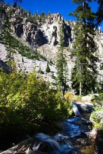
As you’re crossing Iron Creek, be sure to look upstream; there are some great views in that direction. There are also some great views shortly after this, though they’re mostly peek-a-boo.
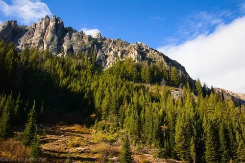
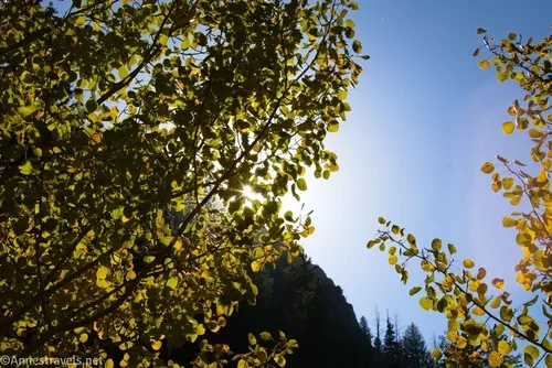
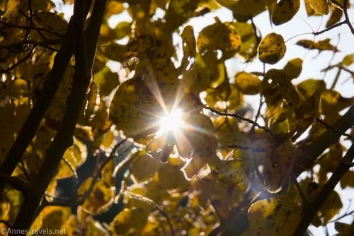
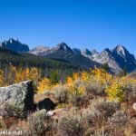
The trail beyond the creek begins to climb gently and in switchbacks up and over the arm of a hill. In late September, the fall colors were amazing, though in the early morning, this part of the trail was in shadow and we didn’t see the full colorful display until our way back that afternoon – and while the views were very different in the afternoon, they were even better!

Cross over the arm of the hill and begin a long, slow descent along the other side of the hill. Keep your eyes open for a sign on a dead tree pointing left where the trail creates a switchback – the sign will say “Alpine Way” – about mile 3.4. You don’t want to follow the sign; instead, continue straight (right) on a slightly uphill path that fairly quickly breaks out of the trees. (Funny thing, but turning left on the Alpine Way is a much less-traveled trail than going straight toward the-sign-doesn’t-say-what!)
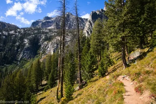
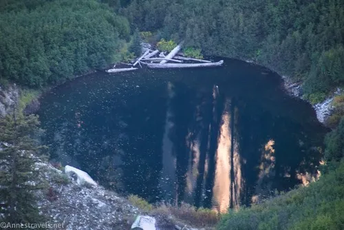
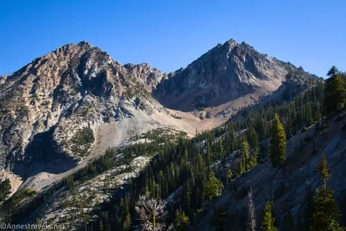
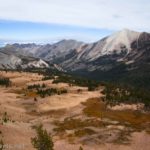
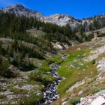
This is where the views begin to get really good. The path is narrow, too, at this point, but easy to hike and follow. An unnamed pond is in the valley below.
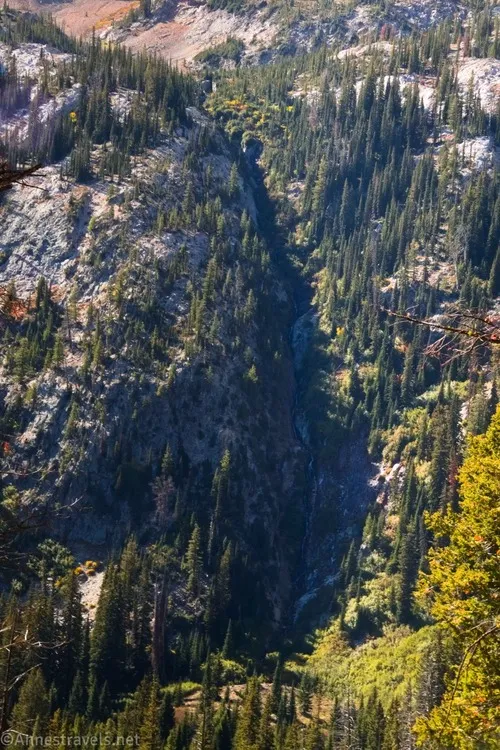
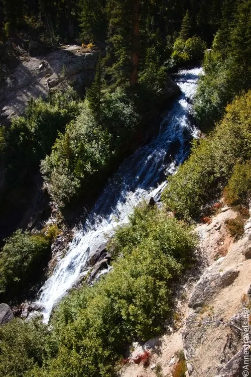
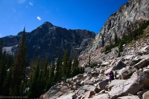
About a mile beyond the junction, you’ll come to two things at more or less the same time: 1) a view of Goat Falls, and 2) a rockslide/scree area. The views of the waterfall are nice…
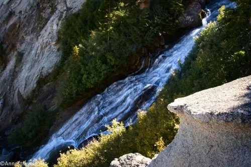
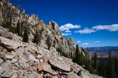
…but the rockslide is where the trail more or less disappears. It turns out that there are two ways to get through this: you can make your own way through the boulders and rocks (not as hard as it might be; the rocks are pretty stable (except when they’re not), and they’re a good size for rock hopping) or you can stay close to the stream and pick up a good if not great trail that might be a bit muddy at times. I opted to go through the rocks on the way up (I didn’t know better) and then took the trail along the stream back down (much easier, but you also miss out on the views).
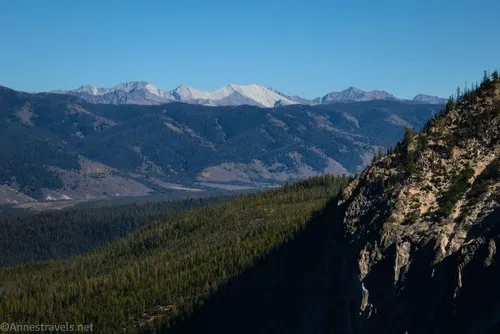
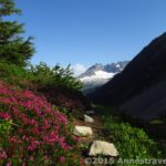
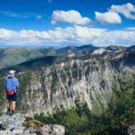
The views while on the rocks are gorgeous both of a sawtooth cliff and down on the plains below the mountains (and across the valley to more mountains).
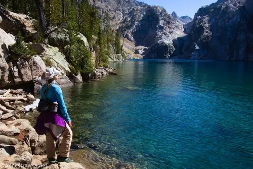
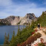
The shoreline (outlet) of Goat Lake is not quite half a mile from the waterfall. This is a beautiful place to see the lake.
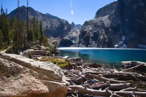
For even more beautiful views, head left along the lakeshore. You can either go along the waterline or rise with a little bit of a scramble up the cliffy rocks (I do think we were following a trail or at least a vague path) to some rocks above the lake. The second was our choice, and it was a great one!
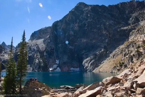
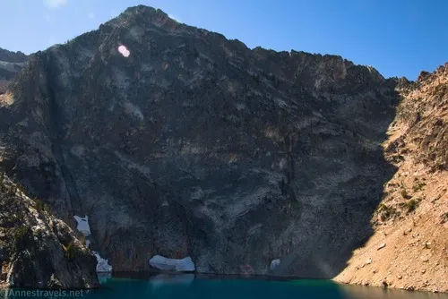
About 0.2 miles from the outlet, we found a place to sit with partial shade and enough of a view to really appreciate the beauty of Goat Lake with its awe-inspiring sheer cliff across the lake.
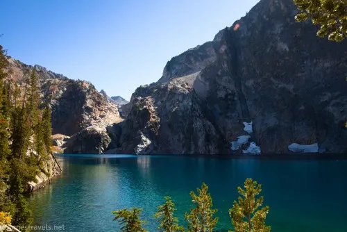
I loved that cliff and how it made me feel so small, but even prettier was the valley at the end of the lake. Interestingly, this valley goes up to Thompson Peak, the highest point in the Sawtooth Mountains. But we didn’t know that as we retraced our steps back to the parking area, and we wouldn’t figure it out until well after our failed attempt at the high point a couple of days later!
Round Trip Trail Length: I went 9.9 miles
Elevation Gain: 2,869ft. (6,721ft. to 8,328ft.)
Facilities: Very primitive restroom at the trailhead and a couple of picnic tables
Fees: None. A free wilderness permit is required for this hike (available at the trailhead).
Trail Notes: The rock scramble section of this hike is not exactly the easiest. I highly recommend descending to the stream to take the trail for easier hiking (though of course this misses out on many of the views in this section). I just couldn’t get over how blue the lake is and the awe-inspiration of the sheer cliff, which made this hike a favorite among my group.
Road 
![]()
Signs ![]()
![]()
Scenery
Would I go 100 miles out of my way for this?
Overall Rating: ![]()
GPS Coordinates for Goat Lake
TH: 44.1986860°, -115.0139780° (44°11.92116′, -115°00.83868′ / 44°11’55.2696″, -115°00’50.3208″) (6,725ft.) (0.0)
Enter the Sawtooth Wilderness: 44.1897960°, -115.0302720° (44°11.38776′, -115°01.81632′ / 44°11’23.2656″, -115°01’48.9792″) (6,998ft.) (1.15)
Marshall Junction: 44.1892760°, -115.0315450° (44°11.35656′, -115°01.89270′ / 44°11’21.3936″, -115°01’53.5620″) (7,014ft.) (1.25)
Alpine Way/Goat Lake Junction: 44.1823040°, -115.0094860° (44°10.93824′, -115°00.56916′ / 44°10’56.2944″, -115°00’34.1496″) (7,434ft.) (3.46)
Waterfall view: 44.1772090°, -115.0167260° (44°10.63254′, -115°01.00356′ / 44°10’37.9524″, -115°01’00.2136″) (8,030ft.) (4.51)
Waterfall viewpoint: 44.1768990°, -115.0172330° (44°10.61394′, -115°01.03398′ / 44°10’36.8364″, -115°01’02.0388″) (8,053ft.) (4.57)
Goat Lake: 44.1748930°, -115.0195260° (44°10.49358′, -115°01.17156′ / 44°10’29.6148″, -115°01’10.2936″) (8,231ft.) (4.95)
Lunch spot: 44.1727000°, -115.0177120° (44°10.36200′, -115°01.06272′ / 44°10’21.7200″, -115°01’03.7632″) (8,319ft.) (5.18)
End: 44.1987130°, -115.0140300° (44°11.92278′, -115°00.84180′ / 44°11’55.3668″, -115°00’50.5080″) (6,725ft.) (9.95)

The gpx file for Goat Lake can be downloaded – please note that this and the GPS Coordinates are for reference only and should not be used as a sole resource when hiking this trail.
Download GPX File size: 200.8 KB Downloaded 29 times
(Note: I do my best to ensure that all downloads, the webpage, etc. are virus-free and accurate; however, I cannot be held responsible for any damage that might result, including but not limited to loss of data, damages to hardware, harm to users, from use of files, information, etc. from this website. Thanks!)
Getting to the Goat Lake Trailhead (Iron Creek Trailhead)
From Ketchum, drive north on ID-75N for 60.9 miles. In the town of Stanley, turn left onto ID-21 S (Eva Falls Avenue). After 2.5 miles, turn left onto Forest Road 619 – the road turns to dirt. Stay on this road for 3.1 miles (there are a fair number of dispersed sites along the road; note that camping is allowed only in the official sites). Just before the Iron Creek Campground gate, turn right into the parking area. (This is not necessarily a logical turn, so keep your eyes open for it. And if you drive too far (you wouldn’t be the first), take the campground loop around, turn left on the road, and try for that perfect turn again!)
More Hikes in the Sawtooth Mountains
Delve deep into the hikes of the Sawtooth Mountains with this guide. Almost 150 trails are covered from so many of the mountains’ most popular (and possibly almost forgotten) trailheads. Buy your copy here!

Pingback: Practical Tips for Spiritually Fathering, Mothering, & Being Fathered/Mothered, Part 1 – Anne's Travels