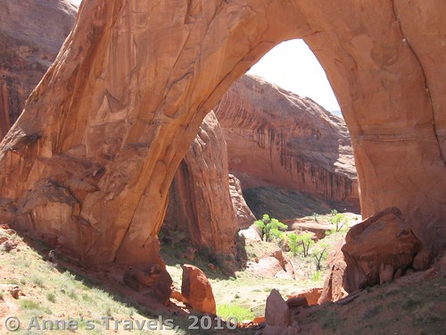
In a former post, I mentioned that Corona Arch was a cross between Delicate Arch in Arches National Park and Broken Bow Arch in Grand Staircase-Escalante National Monument. Well, here I’ll tell you how to see Broken Bow Arch for yourself. The hike winds through a beautiful canyon with a small stream running through it to a spectacular arch on a small plateau above the canyon bottom.
Directions
Broken Bow Arch is located off the Hole-in-the-Rock Road that starts in the northeast part of Grand Staircase Escalante. It is a good dirt/gravel road, although some sections have quite a bit of washboard. It also has some pretty steep hills, but you can get to the parking for the arch in a regular two-wheel-drive, low-clearance car unless it has rained recently, in which case you will need a 4 wheel drive vehicle, or you may not be able to get down the road at all. Check at the visitor center in the town of Escalante for current road conditions.
After you have gone down the Hole-in the Rock Road for about forty miles you will go down into a wash which is called Sooner Wash. The Sooner Rocks are on the edge of the wash and are marked with a sign. About a mile after this you will come to an unmarked side road on your left which goes to Broken Bow Arch and Willow Gulch. Take this road which will take you to the parking area for the arch. After a little while of driving you will go out of the park and into Glen Canyon National Recreation Area. Keep going a little further and pretty soon you will come to a small parking lot with a trail register on one side. This is the parking area for the arch and the end of the road.
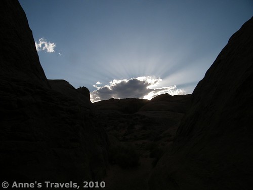
Looking back up the canyon in the afternoon…”They will see the Son of Man coming on the clouds of the sky, with power and great glory…”
The trail to the arch is a three mile hike one way and is strenuous in some places, so be sure to bring plenty of water. The trail starts next to the trail register and goes downhill toward a mushroom-shaped rock and then turns down into the nearby canyon. When you get to the bottom of the canyon you will want to go down the canyon to your right. Make sure that you remember where you went down so that when you come back you will know where to go back out of the canyon. Some people leave piles of rocks to show the way back up.
As you walk down the canyon you will see a slot canyon forming on your left. You do not want to go into it as it is too narrow to go through, although it can be fun to explore if you have extra time on your hands. Keep to your right and follow the trail down the right side of the canyon. As you continue down the canyon you will see the entrance to the slot canyon that has been on your right. If you like slot canyons and tight places you can explore this end of the slot canyon as well. As you continue along the main canyon it will get narrow for a short while and then get wide and branch out into canyons on your right, left, and straight ahead. You want to go into the canyon straight head of you. This is another place that you need to be careful of on the way back.
After you continue down this canyon for a ways, you will come to some wet patches in the ground which will eventually turn into a stream. If you come in a dry time of the year the stream may not start as soon as this, but sooner or later you will probably encounter a stream. At the same time that you meet the stream, you will encounter some bushes growing in the bottom of the canyon which you will have to sort of bushwhack through. However, it shouldn’t be too bad as there is a sort of trail through them. If you do not mind getting your feet a little wet you can walk in the stream where there aren’t so many bushes.
Soon after this the canyon will widen out again and another canyon will come in from the right. At this point you want to go to the left side of the canyon that you are in where there will be a trail up out of the bottom of the canyon and over some sandy hills. Keep on this trail and it will take you across some more sandy hills and then will suddenly turn right and take you down a steep hill and down into the canyon bottom again. Here you will meet the stream again. From now on you will follow the stream down the canyon. You will have to keep switching form one side of the stream to the other as you continue down the canyon, unless you like getting wet—the stream gets pretty deep in places (over my head).
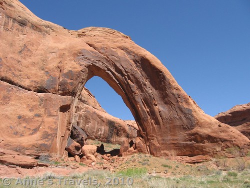
Continue down the canyon for a little more than a mile. As you come around a bend you will suddenly see the arch on your left a little way down the canyon. Go down the canyon a little further and on your right there will be a trail that will take up a small hill and will give a good view of the arch but will not get you to the arch itself. Take your pictures of the arch from here. If you want to get to the arch itself, you will have to go down into the canyon again and follow the stream down a little further past the arch and around the next bend. As you go around the bend, you will see a trail on your left (the side of the canyon that has the arch on) going up the bank on that side of the stream. Go up this trail and it will take you to the back side of the arch.
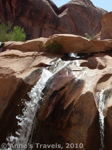
If you want to, you can continue hiking down the canyon. It really is pretty, and there are some interesting features like two huge boulders that come together in an arch over the stream and a small (5-6ft tall, but very wide for the size of the stream) waterfall. I loved the waterfall because the water has worn small “canyons” in the rock ledge, and the water tumbles down these in unique ways that I’ve rarely seen elsewhere. (I’m sorry that I don’t have mileages for how far these features are from Broken Bow Arch, but realize that neither are right around the next bend). I would like to go back someday and go even farther down the canyon toward Lake Powell.
To return to the parking lot, just go back the way you came. It is a pretty long trail and strenuous in places so I would allot yourself at least four hours for hiking time and exploring the arch. If you can, see the arch in the morning, as by mid-afternoon it is in shadow, and nowhere near as impressive. This is also a fairly lonely hike—both times I’ve done this hike we either didn’t meet anyone the entire time we were there, or we only met one or two other hikers. Still, both times there were other cars in the parking lot, so they must have been hiking somewhere else in the area.
Round Trip Trail Length: 6 miles
Facilities: A sandy area that serves as a parking area, trail register
Cost: Free
Trail 


Road 


Signs 


Scenery 


Would I go 100 miles out of my way for this? 


Overall Rating: 


This Week’s Featured Product!
There’s so much wilderness to explore in Grand Staircase-Escalante National Monument and Glen Canyon National Recreation Area. Find some of the area’s best trails in this book!


Pingback: 10 Best (and worst) Day Hikes in Grand Staircase-Escalante
Pingback: 5 Worst Hiking Mistakes I’ve Made - Anne's Travels
Pingback: 15 of the Best Day Hikes in Southern Utah - Anne's Travels
Pingback: Hole in the Rock: Scramble to Lake Powell! - Anne's Travels