The hike from Courthouse Wash to Forget-Me-Not Canyon isn’t exactly a route I’d recommend. It’s filled with rock scrambles, delicate Leave No Trace areas (yes, you can do it; I’ll tell you how), zero official trails, sketchy slickrock, and a small bit of wayfinding. But it also has spectacular views and some really cool features. So I’ll tell you how to hike it, but realize that this is a route only for super-experienced off-trail desert hikers who love views and don’t mind some crazy heights.
Quick Stats

The route begins at the Courthouse Wash Trailhead (the pulloff just north of Courthouse Wash along the Main Park Road in Arches National Park). Take the social trail west (on the same side of the road as the pulloff – don’t use the crosswalk). The path heads for a large fin. It crosses a wash (go straight to pick up the trail on the other side) and then continue to follow the trail until it drops you into the wide Courthouse Wash after about half a mile. Be very careful to stay on the social trail in this area so that you don’t trample the delicate dirt formations or make additional social trails, though at least two trails lead into Courthouse Wash. This part is easy to follow so there’s no excuse for going off the defined trail.

Once in Courthouse Wash, turn right (upstream/west) around the end of the large fin. Soon after the end of the fin, keep your eyes open for a social trail that scrambles up the right (northern) bank (about mile 0.6). You definitely want to find this, and while there may or may not be a cairn marking it, even with the marker it may be difficult to spot.

The social trail will take you across the desert, passing by a couple of side canyons on the right (north). After about 1.2 miles (from the trailhead), it will drop you into another wash.

Actually, I didn’t find the route up the north bank out of Courthouse Wash and instead bushwacked my way through the willows in the trench of the wash (not so hard if you’re wearing long sleeves and slacks and don’t mind ducking). Then I turned up the canyon I wanted to ascend. It wasn’t the greatest route, since just below where you drop into the wash from the overland route, there is a large dryfall with a sketchy, sandy bypass on the left (west). So I definitely recommend the overland route if you can find it!

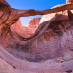
At this point (having dropped into the wash), you can turn right up the wash or you can more or less cross the wash to the trail that cuts off the gooseneck. Sooner or later, though, you’ll be hiking up the wash. Your next landmark will be a large (but short) hoodoo on the left, situated between a small side wash and a cliff of rock about mile 1.5. This cliff houses the Tunnel – and it’s a very worthwhile side trip.

I first visited the Tunnel in 2020 (there’s nothing quite like social distancing by being in a space with 0 other people around!) You can read about that adventure here. The biggest difference I found 3.5 years later is the social trail – it existed in 2020, but it’s much easier to find at this point. The scramble into the Tunnel hasn’t gotten any easier, though. I might have been able to do it on my own, but I was grateful for a tall companion’s pull from above!

The Tunnel is just so cool. Maybe 30 feet in length, and 5-6ft. tall, it’s a delightful little feature that makes me want to grin from ear to ear the whole time I’m in there.

We scrambled back down to the hoodoo and into the main wash. But instead of returning downcanyon, we turned left (upcanyon) toward the canyon head. The walking wasn’t terribly easy, and despite a report on the internet saying that scrambling up the head of the canyon was possible, it certainly didn’t look like it from below. So instead, we turned right up what looked to be a good scramble/slickrock slope that would take us up to the rim. Looking back, we could see the other end of the Tunnel.

The route is sketchy, sandy, and rocky for a bit, then becomes easier once you can scramble up a set of slickrock benches. (Zigzag if you need in order to climb the rounded slopes of the benches.) The steepness makes it a Class 3 scramble, even if I didn’t use my hands much on this area.

The next trick comes when you arrive at the sheer cliff face that reaches up to the rim. To my knowledge, there is only one break in this cliff that allows access to the top – and it’s located considerably left of where you came up. So turn left and brace yourself for some of the sketchiest scrambling I’ve ever done while still feeling fairly safe. There are two methods to this: 1) Stay close to the cliff (stay right) and scramble over massive boulders in a tricky but doable Class 3 route, or 2) Stay closer to the left (near the dropoff) where – usually but not always – you can skirt the boulders altogether for a much easier hike. The downside (literally!) of the left route is that you’re on the edge of a downward-sloping precipice with a 300ft. or so sheer drop into the canyon inches from your feet. I’d call it a Class 4 scramble, even though I could just walk most of it. So it’s little bit of “choose your poison.” (If it tells you anything, we did the first option (rock scramble) on the way out and the other (sketchy cliff) on the way back because the second option doesn’t look doable on the way up.)

When you see a route on the right that allows you to scramble up to the rim about mile 1.9, take it! Then heave a sigh of relief that at least that part of the trail is over – until you have to come back, of course!

From here, strike right across the slickrock. It’s not hard to stay on the slickrock, so be careful to skirt any dirt. (We’re going to do our best to Leave No Trace, and there’s not much excuse to travel on a non-durable surface at this point.) The views are amazing down on Courthouse Wash, but they’re even better if you hike out to a point on the top of the mesa about mile 2.6 (just follow the slickrock and head toward the end of the point – it’s pretty obvious).

I absolutely loved this view. Besides Upper Courthouse Wash (which is very scenic), you also get a great view down on the rock formations at the end of Park Avenue and around the Courthouse Towers Viewpoint. Incredible!

Oh, and I forgot to mention that you can also see to the La Sal Mountains. These views would be better in the afternoon, but by then, the cloudy day with occasional sunshine had really become cloudy. So we didn’t get too many nice photos of the mountains.

When you’ve had your fill of these views, you can either retrace your steps (you’ve seen the best, though there are still amazing things to come), or you can turn left along the rim. You’ll have to go inland a short way to get around a side canyon (I found a Geological Survey Marker not quite at the head of the canyon) before you can strike out for the true rim of the Great Wall. (The Great Wall is a favorite for rock climbers – you’re about to walk along the top of it). Again, stay on slickrock as much as possible (which should be fairly easy in this section).

Once you’ve reached the top of the Great Wall, head north on the slickrock along the rim. Most of the time, the slickrock is easy to follow as it winds around various small side canyons. A couple of times we did have to tiptoe through dirt or sand – try only to walk where others have gone before you. (Amazingly, we did find the footprints of one person who must have visited within a few days of our adventure – and that was about it.)

The views 99% of the time are spectacular. As you head further north, the rock formations around the Windows and the Garden of Eden become clearer. Wow!

We also found a cool little arch.

We were trying to find the head of Forget-Me-Not Canyon, which would technically take us back down to the level of the park road. We did eventually reach the head of the canyon at mile 4.6.

I scrambled down a short distance toward the huge hoodoo/rock formation in the canyon. It was steep but doable.

I also thought I saw an arch to the left of the hoodoo, but I didn’t descend far enough to see if there was a crack of light or not.

So I hear (check out this link to see my super-secret source of information), you can take this canyon down via a Class 4 scramble (mostly Class 3), then follow the wash out to the road. From here, you can walk nearly 2 miles back to your starting point via the Main Park Road. I had little interest in walking that road at all (it’s narrow with a minimal shoulder and very little way to get off of it to avoid cars), so I chose to retrace my steps down to the Tunnel and back to Courthouse Wash.

Except that I thought I’d be clever and take a straighter route via washes across the top of the mesa. Not my brightest idea, though it seemed great at the time! There was simply no way to Leave No Trace. We wash-hopped as much as possible, but it’s not a route I can recommend. Just go back by the slickrock but cut off the detour out to the point with the view of Courthouse Wash; you’ll thank yourself (because it’s easier, not really longer, and definitely better for LNT)!

We finally scrambled back down into the wash with the Tunnel, a little weak-kneed but glowing with all that we’d seen. From there, it was a relatively easy jaunt back to where we’d parked the van – only we saw our first long-nosed leopard lizard along the way!

Round Trip Route Length: I went 10 miles, but I could have cut off about 0.4 miles by not sticking to the washes on my way out.
Elevation Gain: 2,056ft. (4,111ft. to 4,809ft.)
Facilities: None
Fees: $30/vehicle, valid 7 days. America the Beautiful National Parks & Federal Lands Passes and Southeast Utah Parks Passes are accepted. Remember that you may need a timed entry ticket to drive into Arches National Park (currently 7am-4pm April through October).

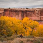
Trail Notes: I know I’ve waxed a long time on how hard this route is, but it’s really not a piece of cake! It would be so easy to slip and fall. I’m really glad I didn’t try to take my mom on it; she did the Fiery Furnace and all of the other crazy hikes like a pro, but not this one. In general, I’d say the views are better in the afternoon, although the area around Courthouse Towers is nice in the morning. It would probably make a better November or March hike (don’t try it when there’s snow) for the angle of the light.

Trail 
![]()
![]()
![]()
![]()
Road ![]()
Signs ![]()
![]()
![]()
![]()
Scenery
Would I go 100 miles out of my way for this?
Overall Rating: ![]()
![]()

GPS Coordinates for the Courthouse Wash to Forget-Me-Not Canyon Route
Courthouse Wash TH: 38.6492800°, -109.5982700° (38°38.95680′, -109°35.89620′ / 38°38’57.4080″, -109°35’53.7720″) (4,129ft.) (0.0)
Wash split: 38.6554140°, -109.6126280° (38°39.32484′, -109°36.75768′ / 38°39’19.4904″, -109°36’45.4608″) (4,158ft.) (1.35)
Hoodoo (near the Tunnel): 38.6594650°, -109.6069990° (38°39.56790′, -109°36.41994′ / 38°39’34.0740″, -109°36’25.1964″) (4,285ft.) (2.09)
Rim (just above where you scramble up): 38.6611890°, -109.6027720° (38°39.67134′, -109°36.16632′ / 38°39’40.2804″, -109°36’09.9792″) (4,580ft.) (3.05)
Courthouse Wash Viewpoint: 38.6577530°, -109.6000550° (38°39.46518′, -109°36.00330′ / 38°39’27.9108″, -109°36’00.1980″) (4,618ft.) (3.43)
Way down (Head of Forget-Me-Not Canyon): 38.6761300°, -109.5944400° (38°40.56780′, -109°35.66640′ / 38°40’34.0680″, -109°35’39.9840″) (4,802ft.) (5.73)
Leave wash to return on the overland trail to Courthouse Wash: 38.6569970°, -109.6101140° (38°39.41982′, -109°36.60684′ / 38°39’25.1892″, -109°36’36.4104″) (4,197ft.) (8.72)
Trail up (where you want to leave Courthouse Wash on your outbound journey): 38.6489380°, -109.6072710° (38°38.93628′, -109°36.43626′ / 38°38’56.1768″, -109°36’26.1756″) (4,122ft.) (9.45)
End: 38.6492930°, -109.5982930° (38°38.95758′, -109°35.89758′ / 38°38’57.4548″, -109°35’53.8548″) (4,128ft.) (10.05)

The gpx file for my route between Courthouse Wash and Forget-Me-Not Canyon can be downloaded – please note that this and the GPS Coordinates are for reference only and should not be used as a sole resource when hiking this trail.
Download GPX File size: 134.6 KB Downloaded 316 times
(Note: I do my best to ensure that all downloads, the webpage, etc. are virus-free and accurate; however, I cannot be held responsible for any damage that might result, including but not limited to loss of data, damages to hardware, harm to users, from use of files, information, etc. from this website. Thanks!)

Getting to the Courthouse Wash Trailhead
From the entrance to Arches National Park at US-191, drive 5.4 miles through the entrance station, past the visitor center, up the hill, and past the two parking areas for Park Avenue. Just after crossing Courthouse Wash, park in the pulloff on the west (left) side of the road.
Today’s Featured Product!
It may not include lots of off-trail routes, but at least this guide isn’t catering to those who only do viewpoints anyway. Enjoy 24 trails to various arches and other features, complete with maps, GPS coordinates, and more. Buy your copy here!