When I talked with locals last summer about the possibility of hiking in the Blue Ridge Mountains near Roanoke, everyone told me about Dragon’s Tooth. Even the people who aren’t huge on hiking had done it and encouraged me to hike up there. It seemed like a great idea: Good views could couple with the two other members of the Virginia Triple Crown (McAfee Knob and the Tinker Cliffs). Despite being the shortest of the three, it’s also the most rugged and the most difficult to hike (rock scrambles that are usually easier than they appear from below). Still, given its status, the uniqueness of the hike, and the views, I highly recommend it if you happen to be in the Roanoke area!
Quick Stats
We started very early one dark and potentially stormy autumn morning (before the trees had turned colors, sadly, but also not in Virginia’s famous muggy heat). The weather report was much better than what we could see as we headed up the wide trail from the sign kiosk.
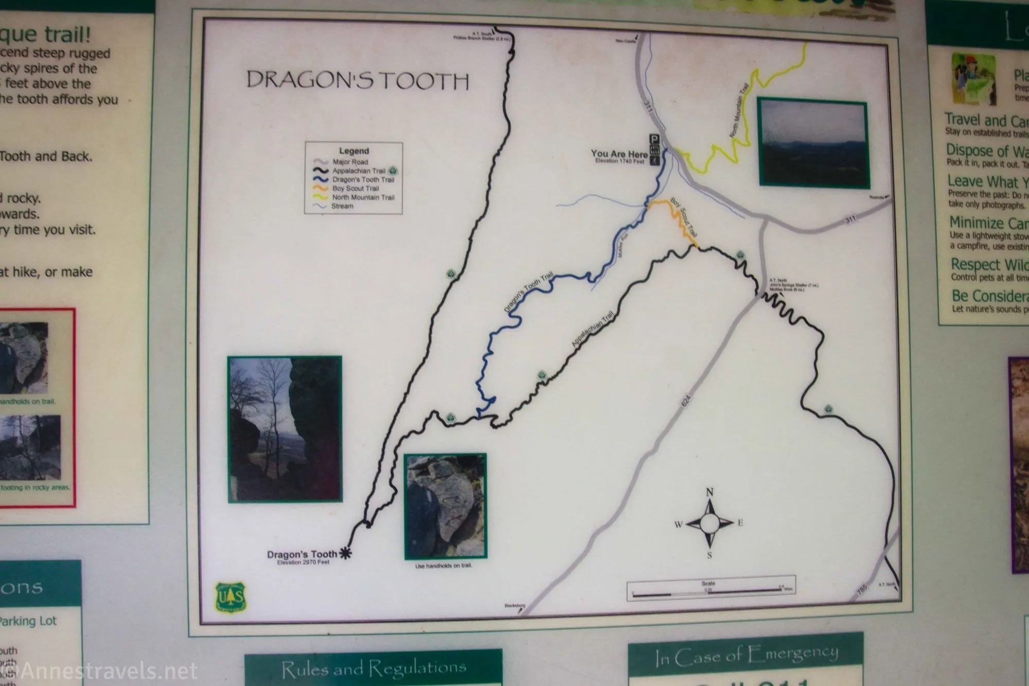
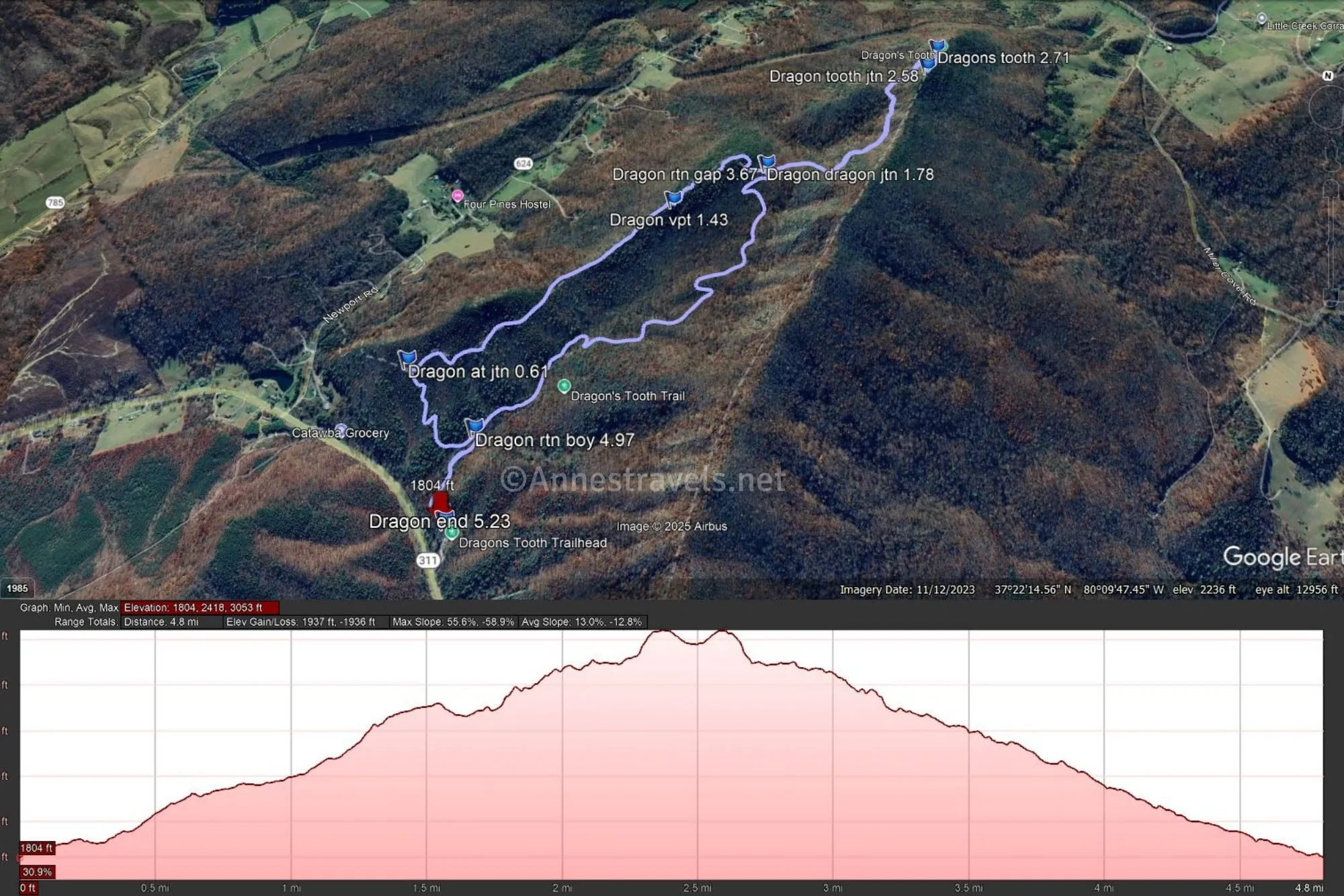
After a quarter mile, the trail splits between the Dragon’s Tooth Trail and the Boy Scout Trail. You’re welcome to go either way, as both take you to the Appalachian Trail and therefore to Dragon’s Tooth. I opted to go left on the Boy Scout Trail first, and I’m glad I did. First, because it’s longer, and it was better to do it while the skies were overcast. Second, because it’s the more difficult of the two routes, and I’d much rather scramble up than down, and several of the scrambles would be much easier to go up. It was very nice to have the easier path after I was tired on the way back down!
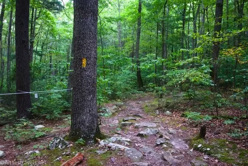
The Boy Scout Trail gives the illusion of an easy hike (watch for blazes on the early part of the path, which was a little confusing), then it begins climbing at an alarming rate. The grade finally alleviates a little shortly before the Boy Scout Trail meets the Appalachian Trail about mile 0.6.
Turn right (southward) on the Appalachian Trail. The junction is well-signed, but there are a lot of references to Dragon’s Tooth; you want to follow the arrow toward Dragon’s Tooth not the Dragon’s Tooth Parking Area. The AT is benign at first and even takes you to a viewpoint on the right about 0.8 miles later.
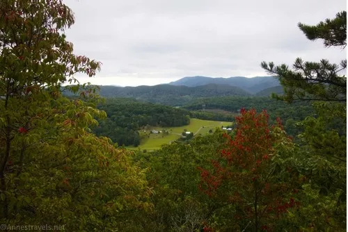
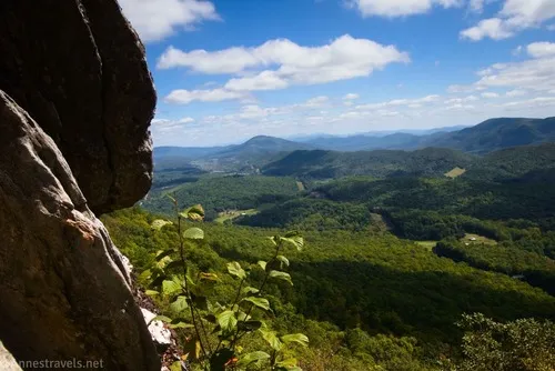
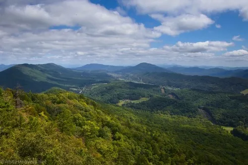
The viewpoint has a nice view, even if it’s a little brushy. You can climb the rocks or continue up the trail just slightly to get on top of the rocks if the brush has grown too high.
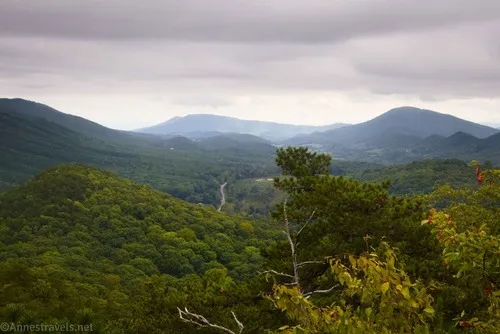
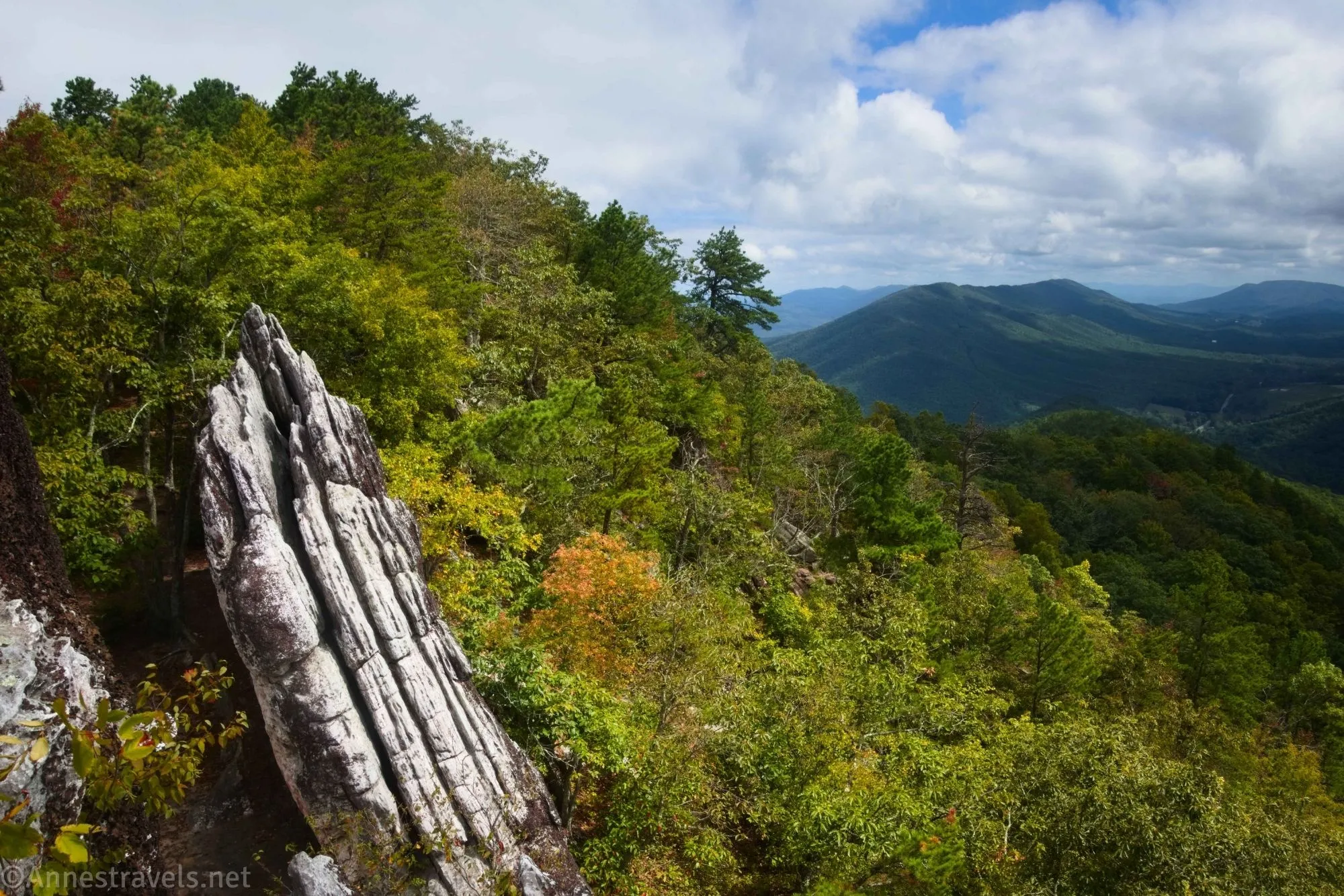
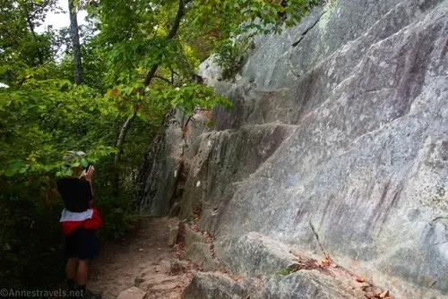
Just after this, the Appalachian Trail begins to give you a taste of what the rest of your hike to Dragon’s Tooth is going to be like. A seemingly sheer cliff is the trail as it rises to a high point on the ridgeline. There are some decent views from the top, if not truly good views due to the trees. Another scramble, and you’re back to the fairly easygoing trail that takes you down into Lost Spectacles Gap at mile 1.8.
This is where you meet up with the top of the Dragon’s Tooth Trail. You’ll turn down this on your way back to the parking area, but for now, continue southward (toward Dragon’s Tooth, not the Dragon’s Tooth Trail) on the Appalachian Trail.
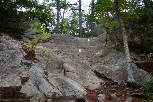
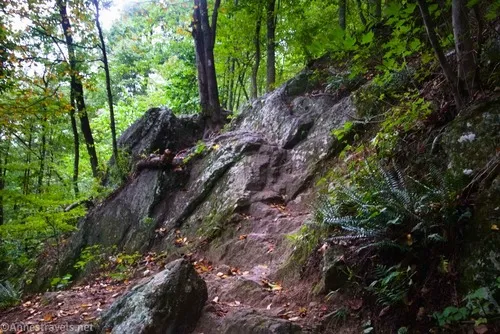
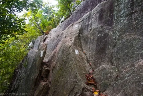
The Appalachian Trail in this section is a bit like a mystery novel. It goes along pleasantly, and then suddenly, you’re walking on stone steps that seem incredibly steep. Back to normal, and then it’s a seemingly sheer cliff to scramble up. Actually, none of the scrambles are all that bad, they just look impossible! Follow the blazes, and you should be fine.
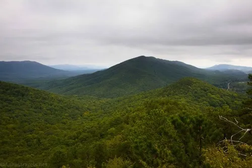
At the top of probably the worst-looking scramble, there is a nice view down into the valley.

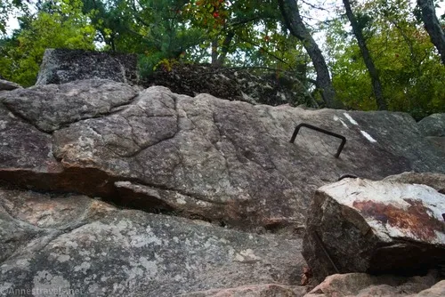
Oh, and then there’s the rock face that requires a metal bar as a step. This hike definitely has some excitement to it!
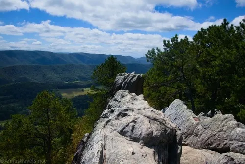
About 0.8 miles from Lost Spectacles Gap, the spur trail to Dragon’s Tooth goes off on the left. Again, it’s well-signed. It’s only about 0.1 miles from here to the viewing area below Dragon’s Tooth.
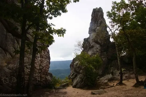
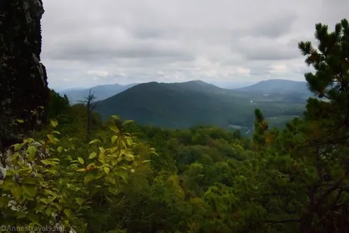
I wasn’t highly impressed at this point. It’s a decent view of the Tooth, itself. But except for a space between the Tooth and the next rock to the left, there isn’t much in the way of a view here.
Feeling a little let down, I followed a path that went around the rocks behind the Tooth. A lot of people must take this trail, as it’s well-beaten (though not as trampled as the viewing area). Pretty quickly, I came to where the rocks parted enough that I could see a way to climb the Dragon’s Tooth. The trail did keep going, but I didn’t explore further – I imagine that if you can’t climb the Tooth, it would give you some reasonable or even excellent views down into the valley.
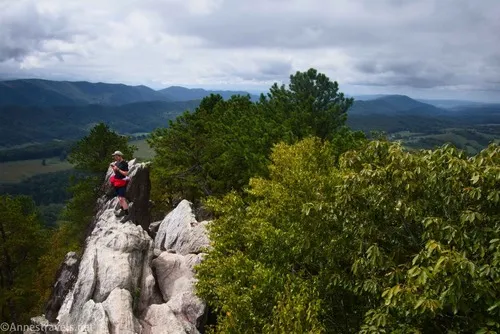
The approach to climb up Dragon’s Tooth is not exactly easy, and it looks even worse than it is. I was seriously doubting my ability to do it after seeing the slot canyon-like rock crack that was the first part of the ascent. This is what turns away most people if my experience that day is any indication. Then I remembered slot canyons in Utah and decided to just try those slickrock scrambling skills and see what happened. Sure enough, it wasn’t half so hard as it looked (even with the choke stone), and I made it up the most difficult part with minimal effort!
The trick is that you can’t scramble straight up the almost sheer canyon wall. Instead, brace your feet on both sides or else both feet on one side and the rest of your body on the other (my preferred method). You can either climb onto a ledge on the left side (my choice) or else climb up under the choke stone (likely the easier route).
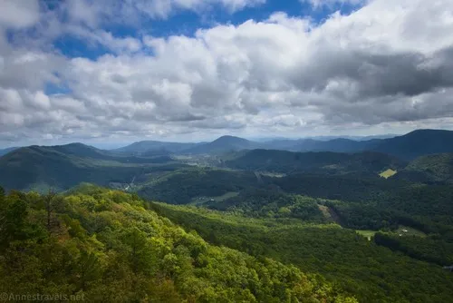
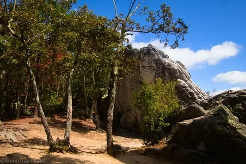
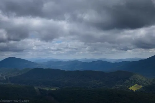
Just above the slot canyon, there’s a very nice area with a good view. Even those who make it this far tend to stop here.
From here, it’s not too hard to go straight up the sloping side of Dragon’s Tooth. It is steep, and it’s not exactly not slippery. I was glad for hiking boots, left my backpack behind, and used both hands and feet… but I made it!

I scrambled back down, both to let my hiking companion have a turn, and also because the view is excellent from both the top and from the lower area. We ate lunch and enjoyed the view… and what do you know, but the sun came out!
As we sat there, another group came along. Apparently, they were all hikers who knew each other through a local Irish music gathering. Anyway, we had a rousing conversation about camper vans, traveling, Irish music, and much more after we gave them the confidence to make it up the slot canyon (they all had to admit it wasn’t as hard as they thought. Or maybe that’s what I heard more than what they said, lol) – they were all very capable, but I guess Utah did me well in figuring out how to make it doable!
By the time we got back down to the viewing area, it had filled up quite a bit! I wanted to tell them all, “Go around! The view is so much better!” but I let taking a few more photos (in the sunshine) suffice.
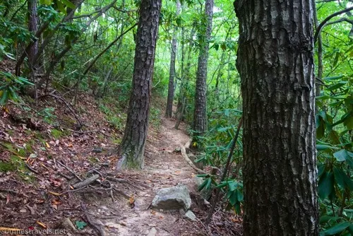
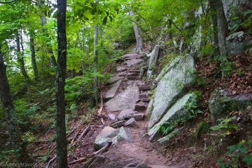
We hiked down those 0.8 miles of scrambles and trail to Lost Spectacles Gap, then turned left down the Dragon’s Tooth Trail. As I hiked through the peaceful forest down a very nicely maintained trail, I couldn’t get over how much easier this was than what I’d already done that day!
Round Trip Trail Length: I went 5.25 miles
Elevation Gain: 1,937ft. (1,804ft. to 3,053ft.)
Facilities: Vault toilet at the trailhead
Fees: None
Trail Notes: Be ready to scramble on this one! The views are great, though. Also, be ready to share this with other hikers whenever the weather is reasonable (and even possibly when the weather isn’t so welcoming).
Trail 
![]()
![]()
Road ![]()
Signs ![]()
Scenery ![]()
Would I go 100 miles out of my way for this? ![]()
Overall Rating: ![]()
GPS Coordinates for Dragon’s Tooth
TH (signboard): 37.3782450°, -080.1558950° (37°22.69470′, -080°09.35370′ / 37°22’41.6820″, -080°09’21.2220″) (1,965ft.) (0.0)
Boy Scout Trail Junction: 37.3755100°, -080.1564580° (37°22.53060′, -080°09.38748′ / 37°22’31.8360″, -080°09’23.2488″) (1,830ft.) (0.25)
AT Junction (Boy Scout Trail): 37.3736720°, -080.1535390° (37°22.42032′, -080°09.21234′ / 37°22’25.2192″, -080°09’12.7404″) (2,035ft.) (0.61)
Viewpoint: 37.3675090°, -080.1628860° (37°22.05054′, -080°09.77316′ / 37°22’03.0324″, -080°09’46.3896″) (2,472ft.) (1.43)
Dragon’s Tooth Trail Junction (Lost Spectacles Gap): 37.3658410°, -080.1665210° (37°21.95046′, -080°09.99126′ / 37°21’57.0276″, -080°09’59.4756″) (2,512ft.) (1.78)
Dragon’s Tooth Spur Junction (almost atop Cove Mountain): 37.3620650°, -080.1729850° (37°21.72390′, -080°10.37910′ / 37°21’43.4340″, -080°10’22.7460″) (3,024ft.) (2.58)
Dragon’s Tooth (viewing area): 37.3608700°, -080.1734970° (37°21.65220′, -080°10.40982′ / 37°21’39.1320″, -080°10’24.5892″) (2,965ft.) (2.71)
Return to Lost Spectacles Gap (turn down Dragon’s Tooth Trail): 37.3658290°, -080.1665420° (37°21.94974′, -080°09.99252′ / 37°21’56.9844″, -080°09’59.5512″) (2,512ft.) (3.67)
Return to the Boy Scout Junction (turn left for the parking lot): 37.3755160°, -080.1564450° (37°22.53096′, -080°09.38670′ / 37°22’31.8576″, -080°09’23.2020″) (1,830ft.) (4.97)
End (parking area): 37.3784110°, -080.1560470° (37°22.70466′, -080°09.36282′ / 37°22’42.2796″, -080°09’21.7692″) (1,759ft.) (5.23)
The gpx file for Dragon’s Tooth can be downloaded – please note that this and the GPS Coordinates are for reference only and should not be used as a sole resource when hiking this trail.
Download GPX File size: 59.5 KB Downloaded 32 times
(Note: I do my best to ensure that all downloads, the webpage, etc. are virus-free and accurate; however, I cannot be held responsible for any damage that might result, including but not limited to loss of data, damages to hardware, harm to users, from use of files, information, etc. from this website. Thanks!)
Getting to Dragon’s Tooth Trailhead
From I-81, take Exit 141 toward VA-419 and VA-311 N and Salem/New Castle. At the end of the exit ramp, turn left (if coming from I-81S) or right (if coming from I-81N) and drive 0.4 miles. In the traffic circle, use the far-right lane (that never really gets into the traffic circle at all) to turn right onto VA-311. The parking area will be on your left after 9.5 miles.
More hikes near Dragon’s Tooth
40 trails near Roanoke and the southern end of the Appalachian Mountains in Virginia are showcased in this guide. Waterfalls, the Blue Ridge Parkway, and much more can be accessed by those looking for hikes for skill levels from easy to much more difficult. Buy your copy here.