I sometimes imagine that it must be hard for explorers to come up with original names for the features they discover. How many Beacon Rocks, Twin Peaks, Old Baldies, Haystack Mountains, Sugarloaf Peaks, and Flat Top Mountains are there in America? (Answer: a lot!) And then sometimes the people who named a feature really have a good point. Such is the case with Elephant Arch in the Red Cliffs National Conservation Area near Washington, Utah (northeast of St. George). It truly looks like an elephant’s head and trunk, complete with an eye in the right place. It’s so cool!
Quick Stats
*Many thanks for your patience with the photos on this page. I’m in the middle of a major photo issue, and I hope to fix this soon.*
The gate at the Mill Creek Trailhead
The traditional route begins at the Mill Creek Trailhead, not far from I-15 Exit 13. I hiked in via the Mustang Pass Trail (which is a beautiful route but a topic for another post), so I’ll describe it as though you were taking the traditional route, which is only 3.6 miles RT (I ended my day at almost 9.1 miles, so you can see why you’d rather do the shorter version!)
Mill Creek sign near the trailhead
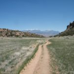
Starting at the Mill Creek Trailhead, step over the stile near the gate. The trail follows the dirt road for the next 0.3 miles. Views stretch northward into the Pine Valley Mountains. I happened to be hiking the day after a snowstorm (we’re talking 4-6 inches in Cedar City), so the mountains were gorgeous when they weren’t shrouded in clouds.
Turnoff for the Elephant Arch Trail
After 0.3 miles, a brown post-like sign on the right points up a very obvious sideroad. The sign is marked “Bone Wash.” Turn right here for 0.6 miles to where the road ends and the trail drops into the wash.
Descending into the wash
The trail up to this point has been fairly firm underfoot because it’s all been on roads used by the “Washington City Culinary Water” (so says the sign on the gate – I’m thinking there are other utilities along with water in the area). Now the tread is very sandy. Walking is harder but still more doable than I expected.
Hiking up Bone Wash
Views were fairly good while on the road, but the canyon part of the trail is more interesting. Sometimes there are rock formations or textures in the canyon walls. The rocks are also incredibly red!
The sign for the turnoff to Elephant Arch
Exactly half a mile after dropping into the wash, the Elephant Arch Trail strikes right. The turn is not well-signed, and it’s easy to miss, especially if you’re enjoying the red rocks and formations around the wash. So I do wonder how many people end up hiking Bone Wash instead of Elephant Arch! The good news is that Bone Wash sounds like a great hike, too, especially if you haven’t already hiked almost 6 miles on a cold, cloudy, miserable day when you really wanted to be out on a fabulously gorgeous hike in Zion National Park (we decided snowy dirt roads just weren’t our cup of tea).
Bushes along the Elephant Arch Trail
Take the turn toward Elephant Arch as it turns up – well, it’s sort of a side wash and sort of a trail. Either way, it’s definitely narrower and sandy. The walls sometimes have interesting holes, a little like the main Bone Wash. Cairns often mark the route.
Heading up to Elephant Arch – if you look closely, it’s in the center of the photo
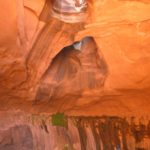
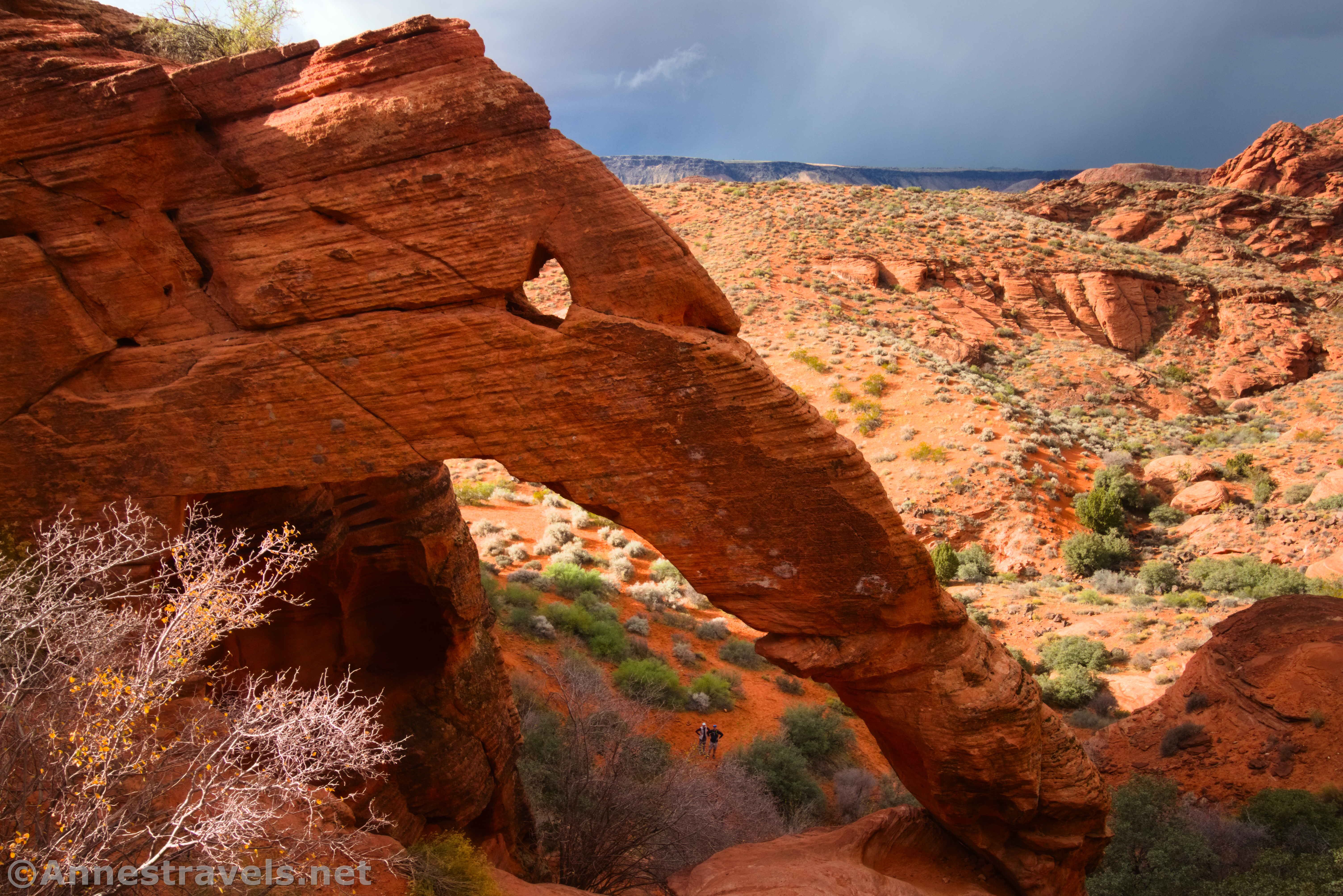
At last, 1.8 miles from the Mill Creek Trailhead, arrive at the area below Elephant Arch. It’s pretty neat from below, and you can see the double arch that makes up the space below the elephant’s trunk and its eye.
Closeup of the front side of Elephant Arch
However, to really see it, you need to have some pretty good scrambling skills. Several social trails head toward the arch, but I found that by going a little to the left, the route was Class 3+ (other routes were definitely worse). All of us made it up, and while we’re all pretty good scramblers, one member doesn’t love heights, and another is (rightly) cautious after a bad tumble a couple of years ago. So all that to say that it’s doable, but it’s really made for the tweens, teens, and young adults who are flexible enough (and crazy enough) to still love climbing. (That said, I saw plenty of 40 and 50 somethings who are still in top scrambling shape!
People in the back side of Elephant Arch
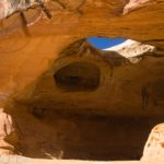
If you can make it up behind (on the east side of) Elephant Arch, you’ll be glad you put in the extra effort. The elephant is so easily seen. And you can scramble inside the arch if you want (use care – it’s a long way down!)
Standing in Elephant Arch
The trail was fairly busy on the day after Thanksgiving (it seems to be a popular place to take out-of-town guests when everyone has a touch of cabin fever). So we arrived just before another group left, then we had it to ourselves for a few minutes, then several other groups arrived. I’d imagine a regular weekday would be much quieter and a nice weekend day would be a madhouse.
Rock formations behind Elephant Arch
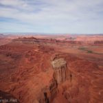
The good news is that you can scramble around (a little) near the formation. This shows off views down on Bone Wash and to nearby cliffs and canyons. It’s pretty impressive.
Views out across Bone Wash and rock formations
When you’ve enjoyed the arch and scenery, scramble back down (use care – it’s slippery!) and retrace your steps to the parking area – or turn right at the junction to continue up Bone Wash for 0.7 miles to the end of the route!
Looking down at the front side of Elephant Arch
Round Trip Trail Length: 3.6 miles
Elevation Gain: 590ft. (3,102ft. to 3,359ft.)
Facilities: None
Fees: I gather there is no fee for this parking area, though it’s possible a $5/day fee (waived with Interagency passes) may be instituted since you’re hiking within the Red Cliffs National Conservation Area.
On the Bone Wash Trail before descending into the wash
Trail Notes: I recommend hiking this trail in the cooler months – October-April. Always take plenty of water. It’s a fairly popular route, so expect to share it with others or even find the parking area full on weekends, holidays, and during high seasons (spring and fall). There has been quite a bit of development in the area in recent years, so things may change, including a possible $5 fee to enter Red Cliffs National Conservation Area. It’s also possible that the trailhead may change – it’s happened to other trailheads in the Mill Creek trail system – though I think it’s unlikely since it’s a utility road. Some say that you’ll need 4×4 to get to the trailhead due to sand, so use caution.
The Pine Valley Mountains from the Bone Wash Trail
Trail 
![]()
![]()
![]()
Road ![]()
![]()
![]()
Signs ![]()
![]()
Scenery ![]()
![]()
Would I go 100 miles out of my way for this? ![]()
Overall Rating: ![]()
![]()
Holes in the side of Bone Wash
GPS Coordinates for Elephant Arch
Mill Creek TH: 37.1616950°, -113.5129130° (37°09.70170′, -113°30.77478′ / 37°09’42.1020″, -113°30’46.4868″) (3,118ft.))
Bone Wash Trail Junction: 37.1657500°, -113.5136770° (37°09.94500′, -113°30.82062′ / 37°09’56.7000″, -113°30’49.2372″) (3,108ft.) (0.3)
Enter wash: 37.1719180°, -113.5067720° (37°10.31508′, -113°30.40632′ / 37°10’18.9048″, -113°30’24.3792″) (3,120ft.) (0.9)
Hiking toward Elephant Arch
Elephant Arch Junction: 37.1748750°, -113.4998570° (37°10.49250′, -113°29.99142′ / 37°10’29.5500″, -113°29’59.4852″) (3,190ft.) (1.4)
Elephant Arch: 37.1773180°, -113.4939970° (37°10.63908′, -113°29.63982′ / 37°10’38.3448″, -113°29’38.3892″) (3,190ft.) (1.8)
Return to Mill Creek Trail: 37.1657070°, -113.5136530° (37°09.94242′, -113°30.81918′ / 37°09’56.5452″, -113°30’49.1508″) (3,108ft.) (3.3)
Mill Creek TH: 37.1616950°, -113.5129130° (37°09.70170′, -113°30.77478′ / 37°09’42.1020″, -113°30’46.4868″) (3,118ft.)) (3.6)
A tiny arch behind Elephant Arch
The gpx file for Elephant Arch can be downloaded – please note that this and the GPS Coordinates are for reference only and should not be used as a sole resource when hiking this trail.
Download GPX File size: 34.3 KB Downloaded 74 times
(Note: I do my best to ensure that all downloads, the webpage, etc. are virus-free and accurate; however, I cannot be held responsible for any damage that might result, including but not limited to loss of data, damages to hardware, harm to users, from use of files, information, etc. from this website. Thanks!)
One last picture of Elephant Arch
Getting to the Elephant Arch Trailhead
Note: The roads in this area are under various stages of development. Be prepared for an alternate route, closed roads, or for work to be happening near or on the roadway. I hear the road is sandy enough that you probably want 4×4 to access it.
Cliffs behind Elephant Arch
From I-15, take Exit 13 toward Washington Parkway. At the end of the exit ramp, turn north (right if coming from I-15E (Hurricane) and left if coming from I-15W (St. George)). Just under a mile later, turn right onto a dirt road; cross over the bike path and drive north until the route is blocked by tanks 0.7 miles later. Turn left here to the next major road after 0.4 miles; turn right 0.4 miles to the small trailhead next to the gate. (Do not block the gate.)
Visual trail map and elevation profile for the Elephant Arch Trail from Mill Creek Trailhead
More Hikes near St. George
To get an idea of more famous, infamous, and lesser-known hikes in the St. George area, check out this book. It serves as a great place to start for hiking, backpacking, and exploring. Buy your copy here!