
The Emmons Moraine Trail is purported to be one of the premier hikes (or at least most popular) in the Sunrise area of Mount Rainier National Park. It’s convenient for the campers, since it begins at the campground, but it’s also open for day hikers. The trail passes through the forest before crossing a glacial stream and ascending a steep (but short) trail to views of the toe of the Emmons Glacier. If you don’t have much time or energy, it can make a good hike, though I personally preferred the views from the end of the Sunrise Road (up near the visitor center; for example, Sourdough Ridge or Burroughs Mountain). It’s also a great jumping-off point for other hikes, but we’ll have to wait for next week for all of that!
Quick Stats
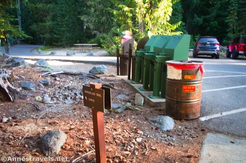
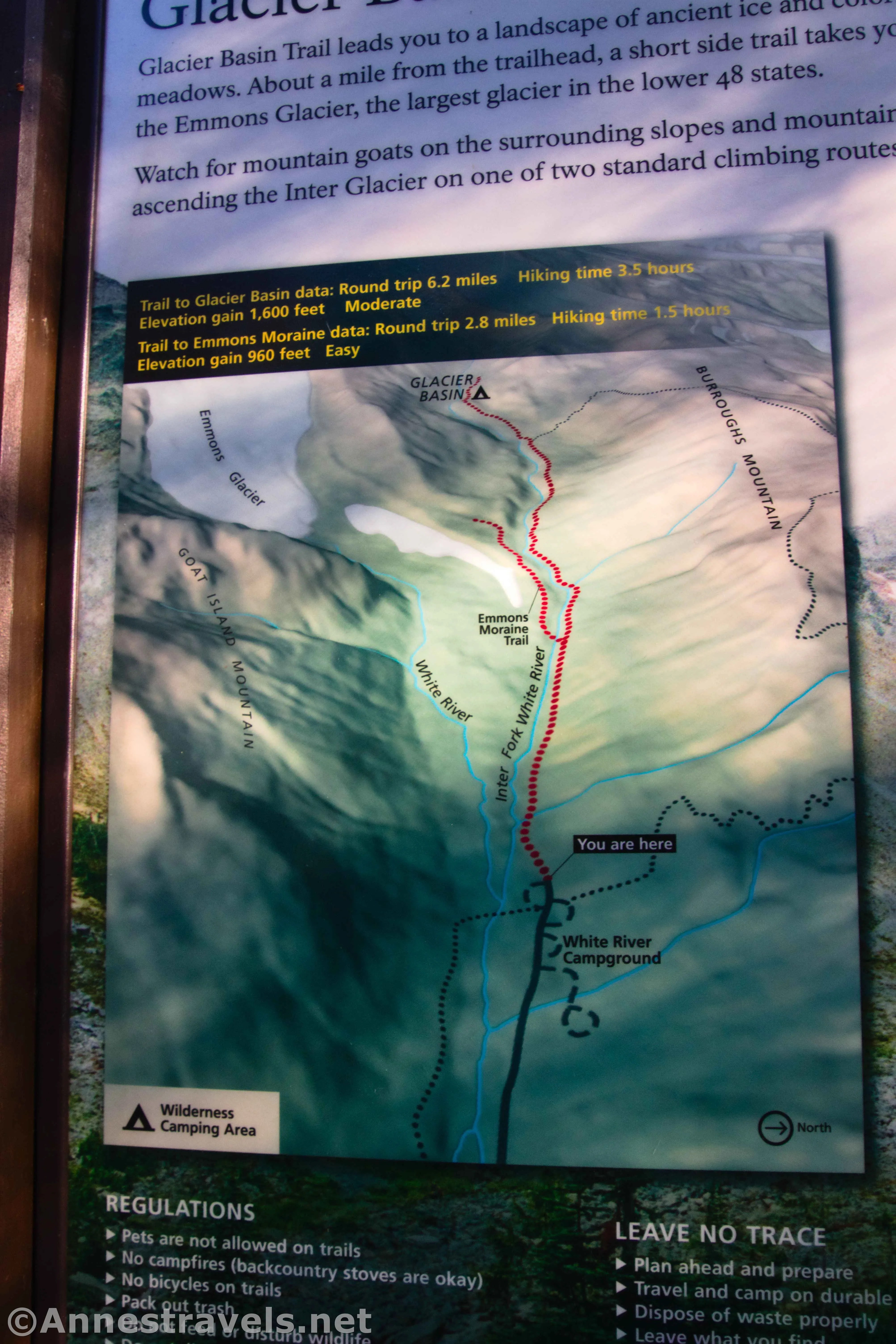
The trailhead for the Emmons Moraine Trail is at the far end of the White River Campground. Amazingly, the campground is first-come, first-serve (no reservations) and there seemed to be half a dozen or so campsites open on a Thursday. (By Friday evening, it appeared to be full.) If you don’t have a campsite (I didn’t), you’ll have to park at the large (but still not necessarily adequate) hiker’s parking area (on the left about halfway through the campground; stay on the main road and you’ll see the signs).
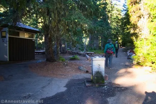
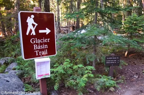
From the hiker’s parking area, begin your hike beside the row of trash cans (restrooms – real flush toilets but no lights – and a water bottle filling station are to your left). Follow the road past the trash cans and take the westerly of the two entrances out onto the main campground road. Turn left; stay right a short distance later when a loop of the campground goes off on the left. When you arrive at a large water fountain and another restroom, walk straight on the dirt path, as this will cut off a loop of the campground. At the end of the trail – about 0.2 miles from the hiker parking area – you’ll see the Glacier Basin Trailhead directly across the paved campground road. Yay! You’ve made it to the trailhead – which might well be the most confusing part of the entire trek! A sign will say that Emmons Moraine is in 1 mile.
Hike up the dirt path to the signboards on the right, then continue through the forest. The path is in good condition and fairly easy hiking, though there are some switchbacks (and therefore somewhat steep grades).
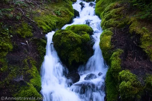
Enjoy the multiple small streams along the path (bridges make them easy to cross). At the end of a switchback about mile 0.9, I could hear what seemed to be an especially nice stream, so I struck right on a social trail. Sure enough, there was a gorgeous cascade – much better than I’d anticipated! I did have to scramble over a couple of fallen trees on the short path down to the base of the falls, so be ready for an adventure to see the waterfall, even though it’s barely off-trail.
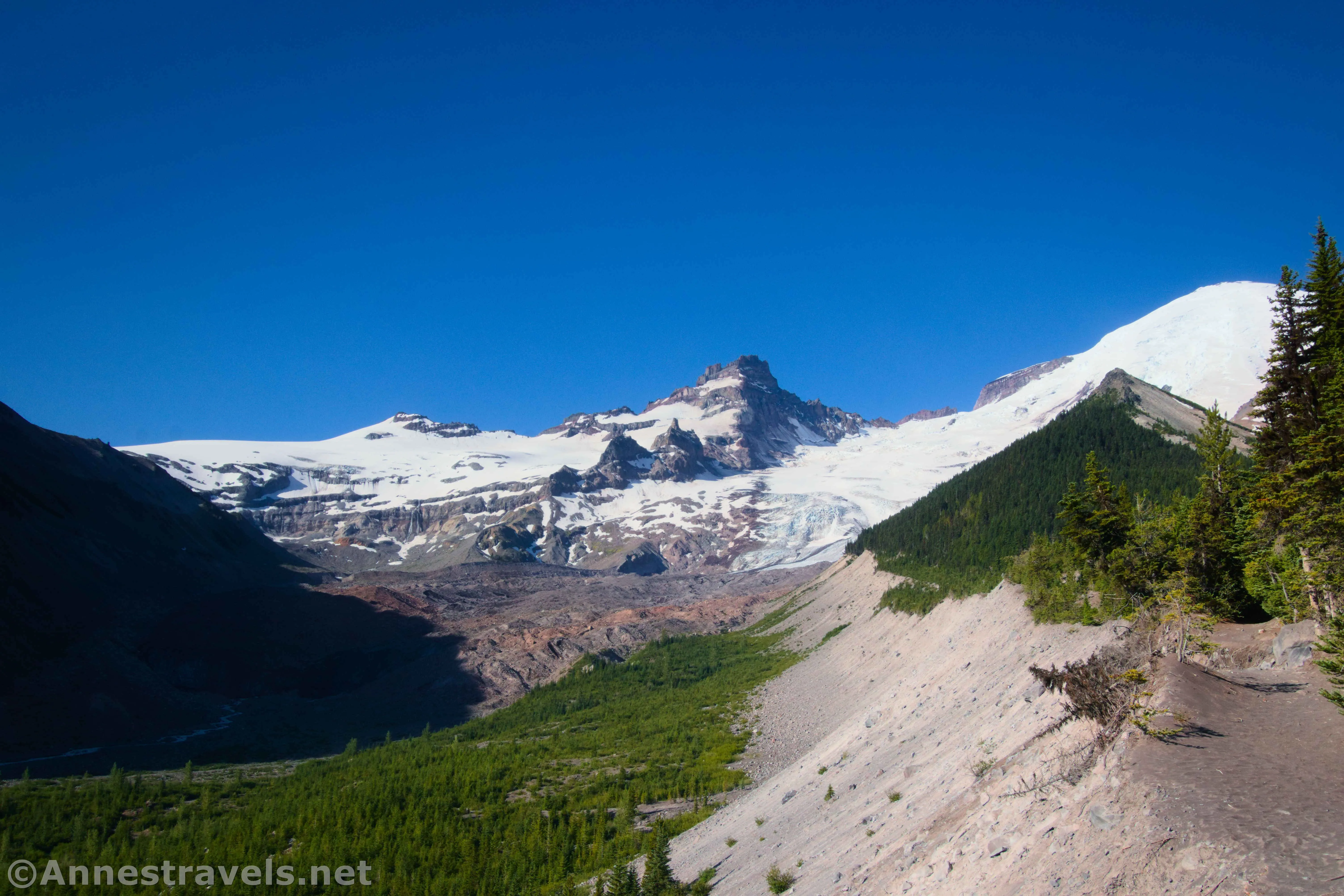
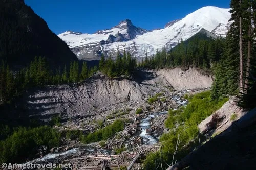
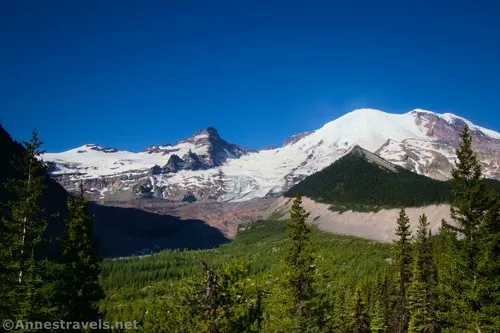
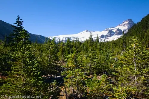
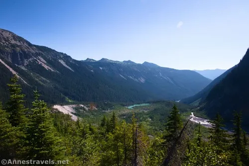
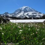
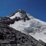
Just before 1.3 miles from the hiker’s parking area, an opening of the forest on the left allows you to look up the Inter Fork (stream) to Mt. Rainier. Now that’s impressive!
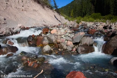
At 1.3 miles from the hiker’s parking area, the well-marked Emmons Moraine Trail strikes off to the left. Turn left here to drop down and cross a log bridge (it’s official and has a railing, but it’s not exactly wide) across Inter Fork. Immediately after the bridge, the trail begins to climb a steep switchback. Thankfully, it’s not a long climb. Social trails strike off on the left as people try to cut short their hike and see the sights while still in the trees. Honestly, it’s not worth the scramble to these viewpoints. You’ll get to the real viewpoint before too long.
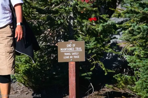
About 0.5 miles after leaving the Glacier Basin Trail, you’ll come to a sign that says, “Trail Not Maintained After This Point.” And granted, what you can see of the trail beyond this looks… sketchy. It’s been undermined on the left, so it’s a bit narrower than it would have been 10 or 20 years ago.
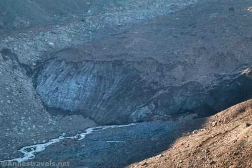
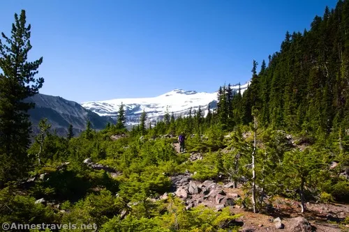
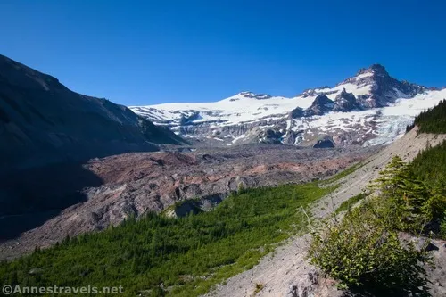
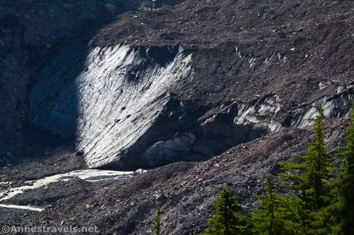
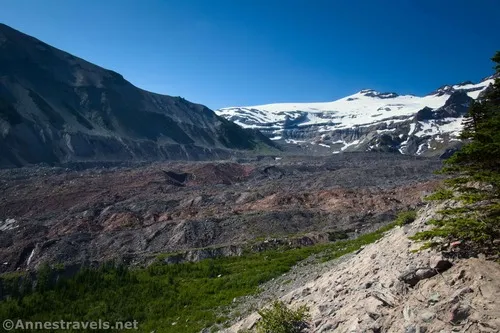
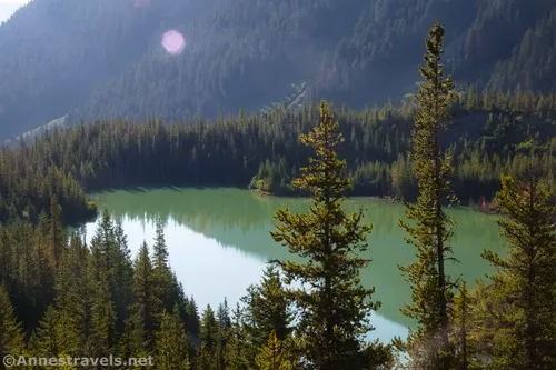
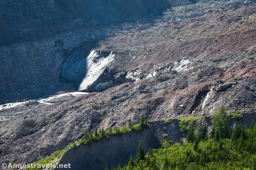
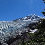
The views from here are fairly good. You can see downcanyon to a small, glacial lake and upcanyon to both the moraine of the Emmons Glacier and even the toe of the glacier if you know where to look (it’s so covered in gravel that it’s hard to spot).
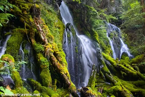
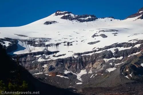
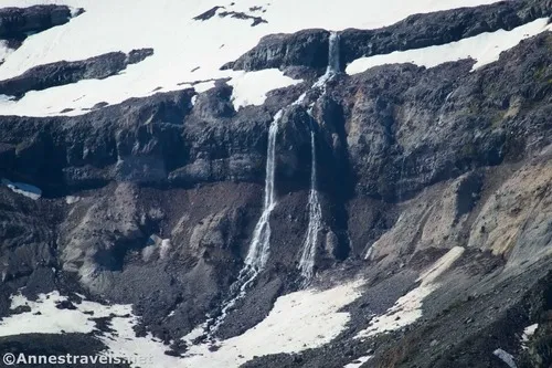
In the morning, you’ll also have a great view of several waterfalls above the glacier.
From the looks of things, most people turn around at the sign. But I wasn’t satisfied with the view, so I hiked a bit further. Don’t get too close to the edge (which is often undercut). There were a few reasonable views along the way, but they weren’t much better than near the “trail not maintained” sign.
At last, the trail turns inland (right) and is surrounded by stunted fir trees. Don’t worry about the trajectory of the trail or that there are multiple social paths. Stay on the main trail, and it will take you uphill (mostly) and where you ultimately want to end up.
Now, if you want to know the truth, I decided the trail wasn’t taking us where we wanted to go, so we bushwhacked all over the place. I can’t say as I recommend it. The trees are sharp, the rocks are real, and there is a lot of elevation gain/loss between the trail and the ridge. Trust the trail!
At 0.5 miles from the “trail not maintained” sign, what is obviously an old road goes off on the right into a pine forest. For now, keep going left as the trail stays outside of the true forest (you’re still in the stunted pines). The path throughout this section is rocky and not the nicest, but it’s also not too bad.
At last, 1.2-ish miles from where you turned off of the Glacier Basin Trail, you’ll crest the edge of the ridge once more. This is the end of the social trail (though you could go further if you wanted to bushwack through thick pines).
The views from here were – in my opinion – better than the ones at the “trail not maintained” sign. But that’s a lot of effort for a bit of a better view, so feel free to turn around when the trail turns inland instead.
On our way back down, we decided to go up the old road to see where it went – but that’s a topic for another post!
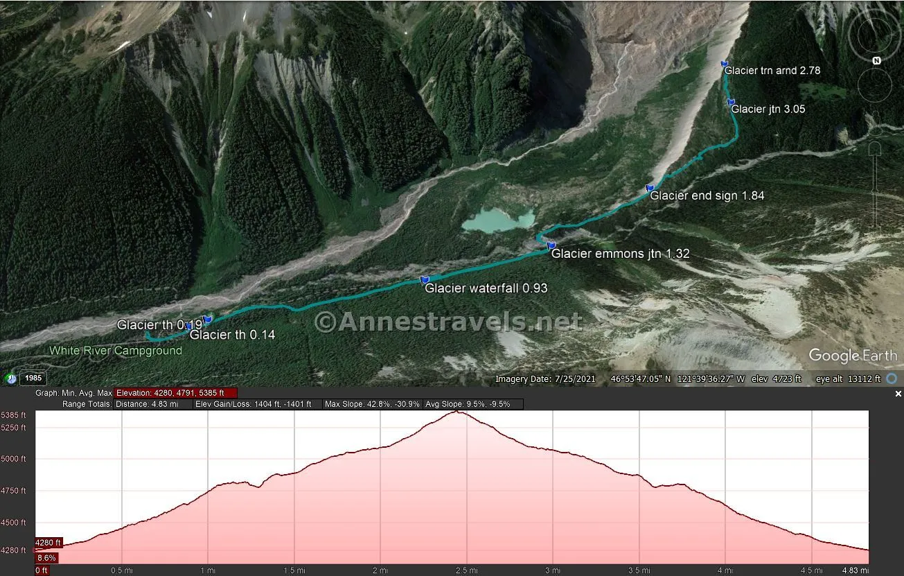
Round Trip Trail Length: With all of my scurrying around off-trail, I would have had a 5.4 mile RT hike. My GPS track (after removing the scurrying) says that it’s only 4.8 miles RT.
Elevation Gain: 1,360ft. (4,280ft. to 5,370ft.)
Facilities: Restrooms, water, trash, picnicking, and camping at the trailhead. Mountain toilet at Glacier Basin Camp (don’t gag)

Fees: $30/vehicle, valid 7 days. America the Beautiful National Parks & Federal Lands Passes are accepted. Between July and early September, timed entry reservations are required between the hours of 7am and 3pm. Without a $2 timed entry ticket (not covered by a park pass), you will not be able to enter the corridor or reach the White River Campground (unless you happen to be already signed into a campsite at the campground) during these hours. Reserve your ticket here. (There’s a reason I get up early!) Also note that the Sunrise corridor (at least to the campground) may still be snowbound throughout the month of May; the higher area of the road may not open until early July.
Trail Notes: Use extreme care beyond the “Trail Not Maintained” sign. While I didn’t have much trouble finding the trail, I did run into a few dead-ends, so be ready to find your way back to the main trail again. There are quite a few social trails that make life more… interesting (especially since most of them are animal trails at best and end quickly). Be especially wary of the undercut edge collapsing beneath you – that’s a long drop to the moraine!
Trail 
![]()
![]()
Road ![]()
Signs ![]()
Scenery ![]()
![]()
Would I go 100 miles out of my way for this? ![]()
![]()
![]()
Overall Rating: ![]()
![]()
GPS Coordinates for the Emmons Moraine Overlook
TH (near trash cans): 46.9017650°, -121.6426230° (46°54.10590′, -121°38.55738′ / 46°54’06.3540″, -121°38’33.4428″) (4,280ft.) (0.0)
2nd Restroom (cutoff trail): 46.9019540°, -121.6449980° (46°54.11724′, -121°38.69988′ / 46°54’07.0344″, -121°38’41.9928″) (4,314ft.) (0.14)
Glacier Basin TH: 46.9017110°, -121.6459250° (46°54.10266′, -121°38.75550′ / 46°54’06.1596″, -121°38’45.3300″) (4,325ft.) (0.19)
Waterfall: 46.9011310°, -121.6580170° (46°54.06786′, -121°39.48102′ / 46°54’04.0716″, -121°39’28.8612″) (4,641ft.) (0.93)
Emmons Moraine Trail Junction: 46.9001260°, -121.6653180° (46°54.00756′, -121°39.91908′ / 46°54’00.4536″, -121°39’55.1448″) (4,814ft.) (1.32)
“End of Maintained Trail” Sign: 46.8977210°, -121.6718050° (46°53.86326′, -121°40.30830′ / 46°53’51.7956″, -121°40’18.4980″) (5,011ft.) (1.84 Note – all mileages beyond this are 0.7-0.8 miles off due to getting off the trail)
Turn around (end of trail): 46.8906180°, -121.6794350° (46°53.43708′, -121°40.76610′ / 46°53’26.2248″, -121°40’45.9660″) (5,367ft.) (2.78)
Old road junction: 46.8931140°, -121.6787990° (46°53.58684′, -121°40.72794′ / 46°53’35.2104″, -121°40’43.6764″) (5,241ft.) (3.05)
The gpx file for the Emmons Moraine Trail can be downloaded – please note that this and the GPS Coordinates are for reference only and should not be used as a sole resource when hiking this trail.
Download GPX File size: 27.6 KB Downloaded 66 times
(Note: I do my best to ensure that all downloads, the webpage, etc. are virus-free and accurate; however, I cannot be held responsible for any damage that might result, including but not limited to loss of data, damages to hardware, harm to users, from use of files, information, etc. from this website. Thanks!)
Getting to the Emmons Moraine Trailhead
If you’re staying in the campground, you can simply walk to the trailhead. However, for those coming in from outside, here are some directions:
From the Sunrise Entrance Station (1.3 miles off of WA-410), continue on the main park road. When the Sunrise Road diverges into a switchback after 4.0 miles (just after crossing the White River), bear left to continue toward the White River Campground. After 1.3 miles, turn left into the parking area (I believe it’s signed for backpackers or overnight hikers, but it’s actually also for day hikers).
Today’s Featured Product!
Enjoy some of Washington’s best scenery (including trails in Mt. Rainier National Park) with this book. It showcases photos, maps, GPS coordinates, and more. Buy your copy here!

Pingback: An Old Mining Road & the Climbers Trail to Emmons Glacier Vistas! – Anne's Travels