

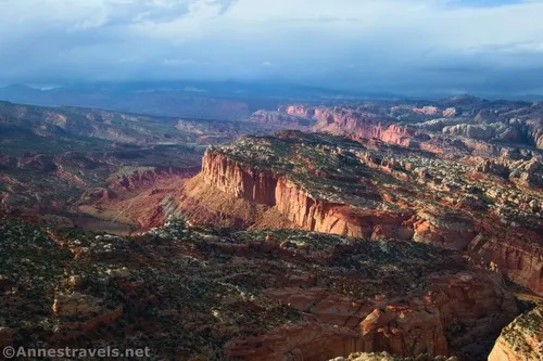
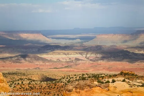
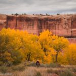
I finally found my favorite hike in Capitol Reef National Park, but it has a ridiculous name: Fern’s Nipple. So the story goes, Butch Cassidy named it after one of his girlfriends. I prefer the story of an early settler with his baby daughter’s bottle, but either way, the dome above Grand Wash offers the most outstanding views I’ve ever seen in the park (or possibly in the entire region). Views stretch for miles and miles in every direction to include a wide variety of canyons, mountains, rock formations, plains, and much more.
Quick Stats
There’s one big catch to this amazing and wonderful view: There’s no trail to the summit. In fact, most of the hike is a scramble of one sort or another, with the final ascent at a Class 3-Class 4 rating. Harder for me was trying to follow the non-existent trail. Someone keeps up the cairns (usually), but significant wayfinding is still required.
The trailhead for Fern’s Nipple is the same as for Grand Wash (and Cassidy Arch). The parking area is small, so most people park where permitted down in the wash. We were able to find a spot mid-morning on a weekday in October, but I expect that was because someone had left… there were a dozen or more cars in the wash already.
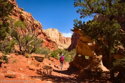
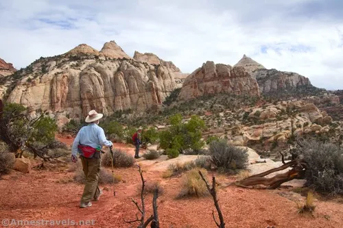
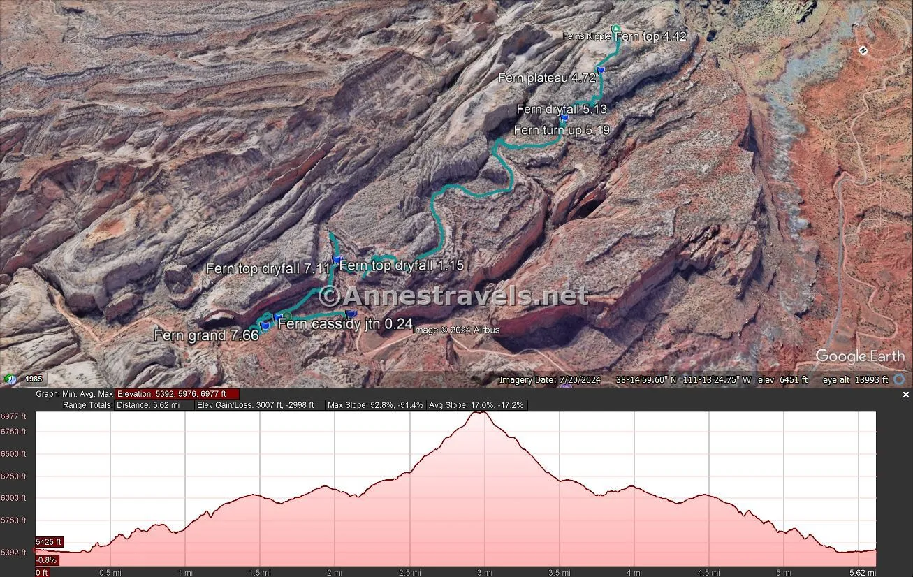
From the trailhead sign, follow the path along the left edge of Grand Wash. There are cairns, and since this is an official hike, the trail and cairns are both kept up by the National Park Service. Just before the Cassidy Arch Trail goes off on the left at mile 0.25, the trail will drop you into the wash. (Actually, there were ways to drop into the way before this, and possibly even one or two places where it was required, but this is the first place where the trail doesn’t reascend onto the bank almost immediately.)
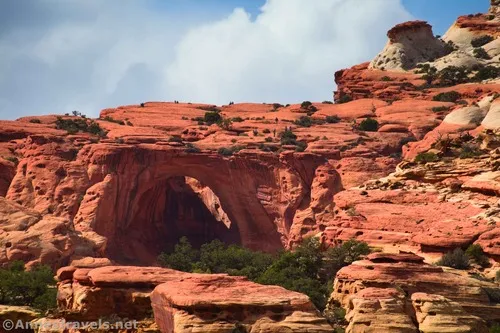
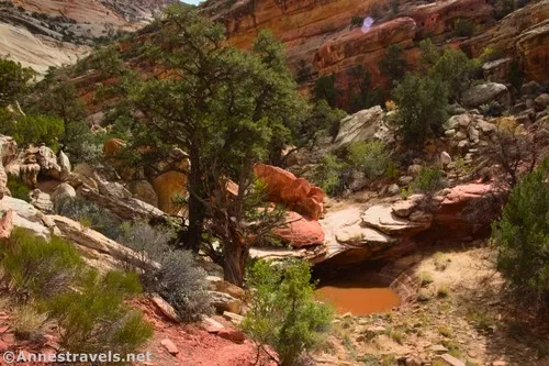
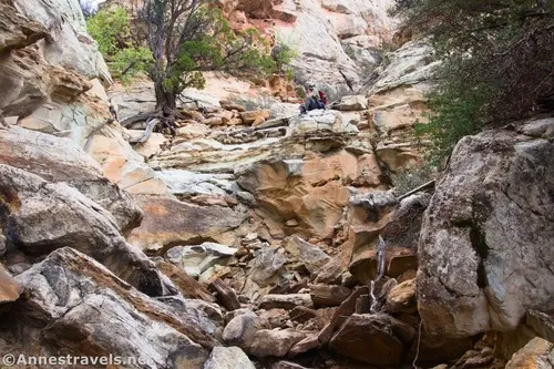
Drop into Grand Wash instead of turning up toward Cassidy Arch. (I actually did hike up to Cassidy Arch at the age of 13, but since I don’t remember much about it except that the smoke from wildfires in California blew in and the views were terrible, I’ll forgo telling you about that trail.) Walk about 300ft. further up the wash, then turn right to scramble up the rocks. Follow social trails (some safer than others) to ascend up to the top of the bench below the sheer cliff wall.
I’m making this part of the hike sound easy. It’s not. For one thing, figuring out which social trail to follow is a challenge, and secondly, the terrain is very rocky and occasionally slippery or with some pretty good exposure. You’ve been warned.
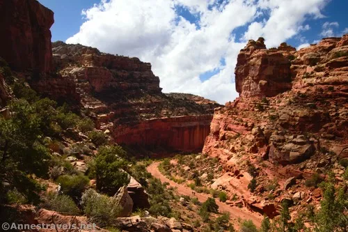
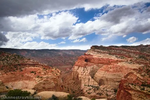
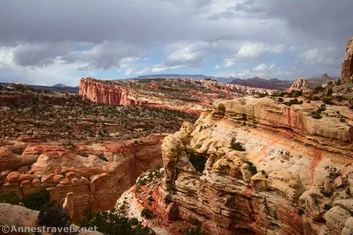
Once atop the bench, the path (such as it is) turns right to head back downcanyon along the top of the bench. Views from this section of the hike were absolutely spectacular down on Grand Wash and across the canyon to Cassidy Arch (I do have to wonder if a few of the people there were wondering what those crazy tourists were doing…)
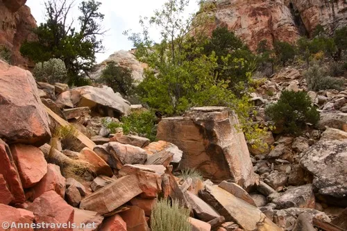
If you’re following the social trail, you’ll probably miss the fact for a minute that the route turns left up Bear Canyon. However, this becomes apparent eventually. The path takes you above the Bear Canyon Wash, which eventually rises up to your level via a dryfall (marked “Top of Dryfall” on the map). There is one nasty scramble just after the top of the dryfall where you’ll need to work your way through a couple of huge boulders on the left side of Bear Canyon. It wasn’t the worst part, but it was a little looser/narrower than I like.
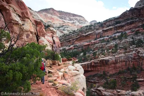
I made the mistake of continuing up Bear Canyon at this point – while I’m sure that would be a fun adventure, it’s not the way to Fern’s Nipple (note that I’ve adjusted the mileages to suggest that we didn’t take this wrong turn, but the map still shows the old mileages). Instead, turn right a short distance above the dryfall to cross the canyon and begin up the other side. I was able to pick up the cairn trail (or even a physical trail where it didn’t go across rock) at this point. This is the hardest part of the route to follow, as you’re trying to gain elevation (but not too much too quickly) go over the top of the wall separating Bear Canyon from the canyon to the south (Na-Gah Fork), but to do so, the route zigzags up and around and finally over but not over the top of the wall (that’s not confusing at all, right?) There is one slightly sketchy scramble section, but nothing worse than a Class 3.
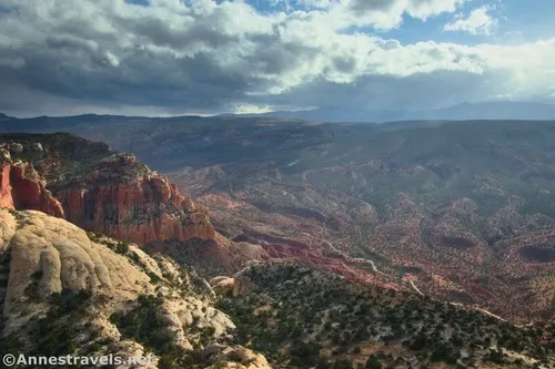
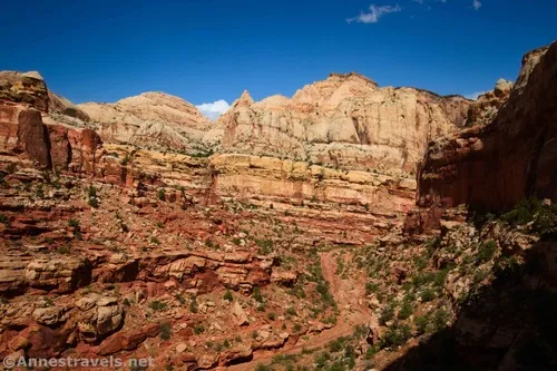
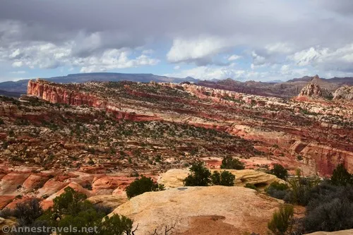
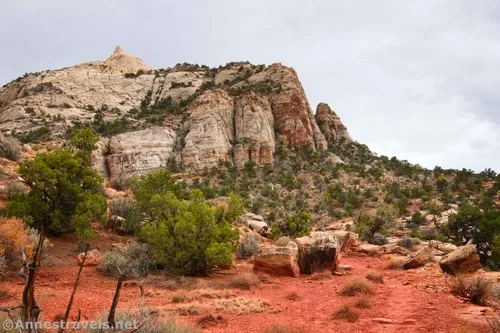
Once you’re finally around this obstacle, the route becomes more logical. You’re mostly just hiking along and around the rims of two canyons (Na-Gah Fork and then Timple Fork). The views from here are impressive. We found a nice overlook that would be a great place to turn around if you don’t want to go all of the way up to Fern’s Nipple. Unfortunately, the afternoon turned cloudy about this point and we even hid from the sprinkles for a short while underneath an overhang. I’d love to go back on a nicer day!
As we came to the head of the third canyon (Nighthawk Fork) about mile 2.4, I spotted a sidecanyon chute in the cliffs on the left that seemed like it would be a semi-reasonable climb. This is the way up to Fern’s Nipple! I highly recommend that you use a GPS coordinate to find this turn (38.2516430°, -111.2144830°), as while it seemed obvious to me, it’s actually not that easy to spot!
The scramble up this drainage is tons of fun if you like to scramble – and if you’re looking for a stroll in the park, you’d be better off turning around before this! There are rock slides, dryfalls, and all kinds of fun. Most of it was minor (if steep) Class 3, but there was one dryfall that posed a Class 3+ obstacle. Thankfully, the difficult section is only a tenth of a mile or a little more.
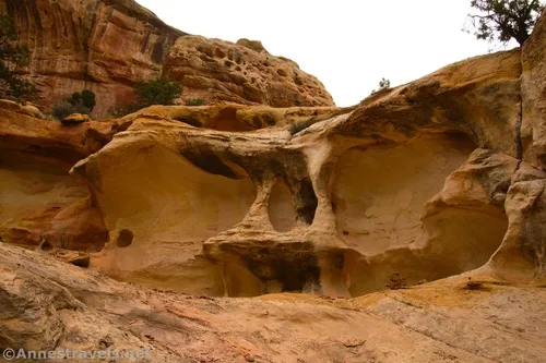
Above the dryfall, the route climbs over white rock through the desert. You know you’re getting close when the desert gives way to plain white rock. Just before the final push to the summit, you’ll need to cross a small canyon. It’s quite easy on the left side and more of a drop to the right.
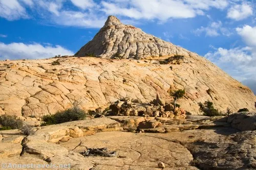
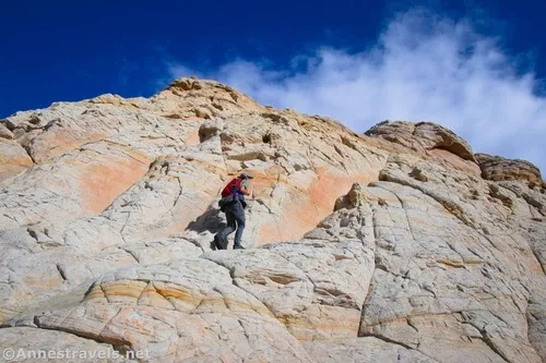
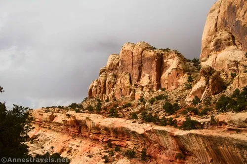
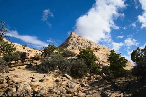
The summit block of Fern’s Nipple is where most people chicken out. The views are excellent from below, so one of my group members decided to stay down on the other side of the canyon (which is another great turn-around spot). The other two of us scrambled up the beehive-like summit block. Several routes were close to a Class 4, though on the way back down, I found out that it’s a lot easier (and safer) to shy to the left (slightly more north, though you’re still on the northwest face).
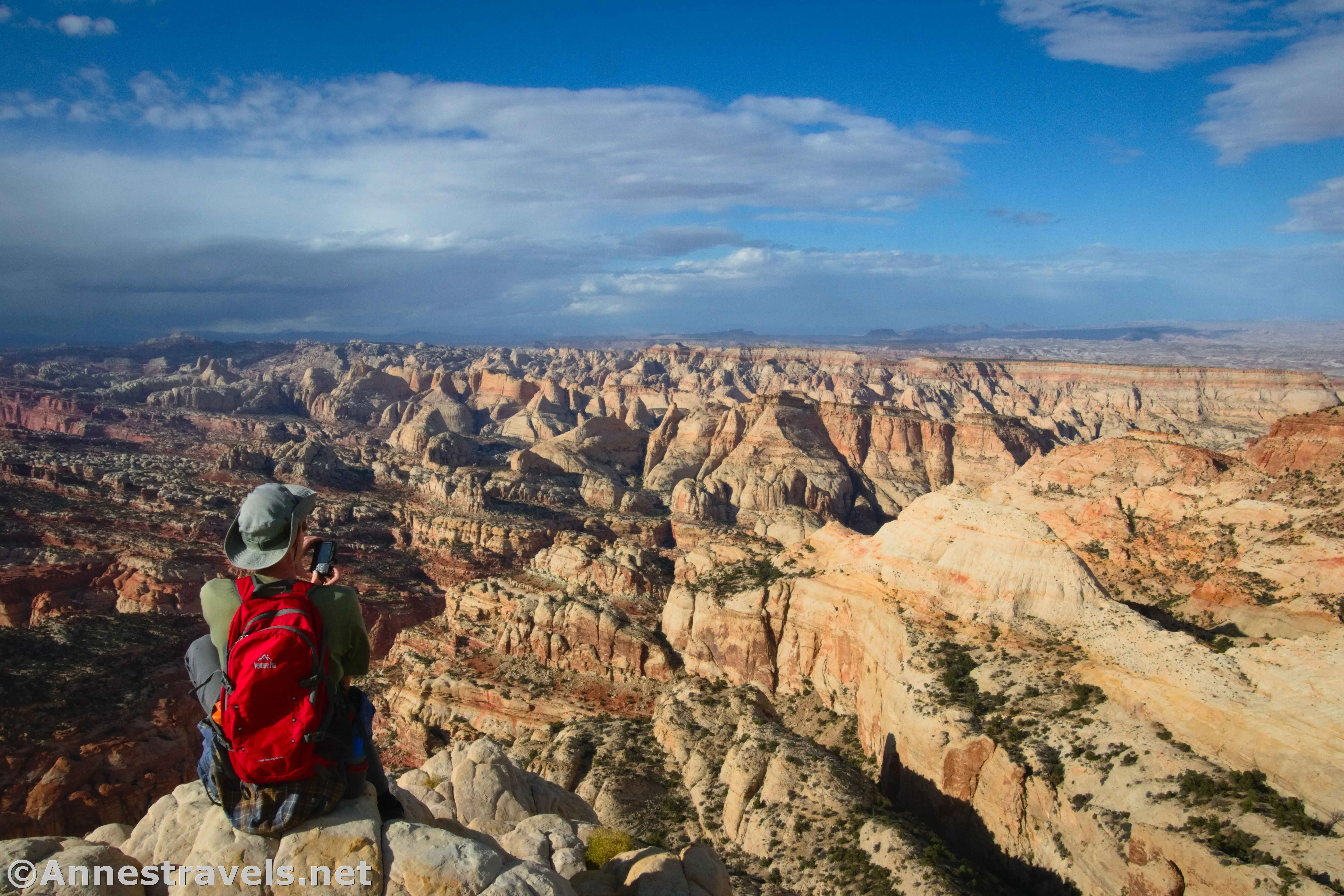
And then, much faster than I expected, we were at the top, 2.9 miles from the trailhead! Wow! It looked so much harder than it actually was (especially that last scramble to the very top).
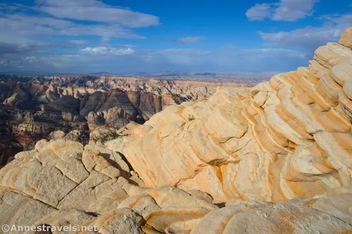
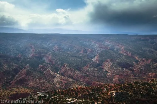
But then I stood up and looked around – and my jaw dropped. It didn’t matter which way I turned, the view was stunning!
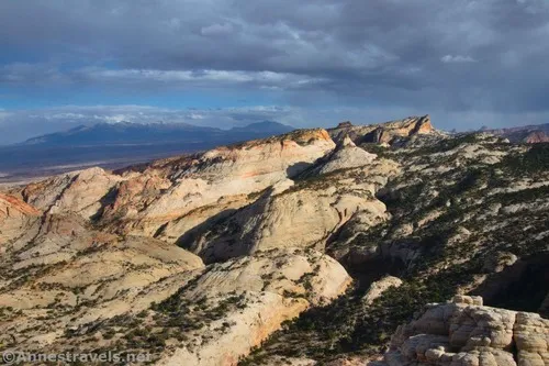
We had been dancing around rain clouds all day, which made the view even more dramatic up here. But we were also just in time to get some glorious sunshine. I couldn’t stop taking pictures and admiring the view!
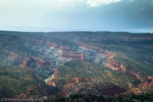
I didn’t capture it in any of the photos, but the nearby mountains were studded with aspens in color (I was hiking in early October). That was special! I also enjoyed the scenery that looked like it could have come out of Cedar Breaks National Monument.
It was already late (we’d gotten a much later start than we intended – that’s another story that ends with meeting some truly wonderful people who helped us out), so we didn’t spend much time at the top. As it was, we skittered our way back down into Grand Wash right as darkness was falling – which was a good thing; I don’t think we could have retraced our steps down in the dark!
Round Trip Route Length: 5.6 (or a bit more)
Elevation Gain: 3,007ft. (5,392ft. to 6,977ft.)
Facilities: None
Fees: $20/vehicle, valid 7 days. America the Beautiful National Parks & Federal Lands passes and Capitol Reef Annual Passes are accepted.
Trail Notes: This is a long, difficult, dangerous hike. Start early, be prepared to self-rescue, and use common sense. It’s also very difficult to follow, so you should be very good at finding your own route through the desert. I do provide a GPS file, but I can’t guarantee that it’s spot-on perfect (I had to fix several places where the GPS became confused in the confines of the canyons). Cell service is very limited on this hike. Much of the route is very exposed to the sun, so I highly recommend doing it in the cooler months of the year (October-April). With all of those discouraging words, let me also say that the views are amazing, even from partway up, and if you’re used to hiking desert canyons (including slot canyons with plenty of scrambles), you shouldn’t have much trouble on this hike.
Trail 
![]()
![]()
![]()
![]()
Road ![]()
![]()
Signs ![]()
![]()
![]()
![]()
Scenery
Would I go 100 miles out of my way for this?
Overall Rating: ![]()
![]()
GPS Coordinates for Fern’s Nipple
Grand Wash TH: 38.2637690°, -111.2156100° (38°15.82614′, -111°12.93660′ / 38°15’49.5684″, -111°12’56.1960″) (5,421ft.) (0.0)
Cassidy Arch Junction: 38.2659040°, -111.2134060° (38°15.95424′, -111°12.80436′ / 38°15’57.2544″, -111°12’48.2616″) (5,395ft.) (0.24) (0.2 fixed)
Top of dryfall: 38.2628040°, -111.2129380° (38°15.76824′, -111°12.77628′ / 38°15’46.0944″, -111°12’46.5768″) (5,579ft.) (1.15) (0.7 fixed)
Dryfall: 38.2513880°, -111.2140930° (38°15.08328′, -111°12.84558′ / 38°15’04.9968″, -111°12’50.7348″) (6,268ft.0 (3.67) (2.5 fixed)
Top of Fern’s Nipple: 38.2473510°, -111.2129980° (38°14.84106′, -111°12.77988′ / 38°14’50.4636″, -111°12’46.7928″) (7,046ft.) (4.42) (2.9 fixed)
Plateau (just before the canyon): 38.2493120°, -111.2142580° (38°14.95872′, -111°12.85548′ / 38°14’57.5232″, -111°12’51.3288″) (6,693ft.) (4.72) (2.75 on the way up; fixed)
Dryfall: 38.2513700°, -111.2141340° (38°15.08220′, -111°12.84804′ / 38°15’04.9320″, -111°12’50.8824″) (6,262ft.) (5.13)
Turn up: 38.2516430°, -111.2144830° (38°15.09858′, -111°12.86898′ / 38°15’05.9148″, -111°12’52.1388″) (6,217ft.) (5.19) (2.4 on the way up; fixed)
Top of dryfall: 38.2628930°, -111.2128680° (38°15.77358′, -111°12.77208′ / 38°15’46.4148″, -111°12’46.3248″) (5,591ft.) (7.11) (5.2 on the way down; fixed)
Grand Wash: 38.2664560°, -111.2133990° (38°15.98736′, -111°12.80394′ / 38°15’59.2416″, -111°12’48.2364″) (5,389ft.0 (7.66) (3.5 on the way down; fixed)
End: 38.2638500°, -111.2155330° (38°15.83100′, -111°12.93198′ / 38°15’49.8600″, -111°12’55.9188″) (5,429ft.) (8.06) (5.6 on the way down; fixed)
The gpx file for Fern’s Nipple can be downloaded – please note that this and the GPS Coordinates are for reference only and should not be used as a sole resource when hiking this trail.
Download GPX File size: 189.2 KB Downloaded 358 times
(Note: I do my best to ensure that all downloads, the webpage, etc. are virus-free and accurate; however, I cannot be held responsible for any damage that might result, including but not limited to loss of data, damages to hardware, harm to users, from use of files, information, etc. from this website. Thanks!)
Getting to Fern’s Nipple (Grand Wash) Trailhead
From the Capitol Reef National Park Visitor Center, follow the scenic drive south past the campground. After 3.4 miles, turn left on the road that will be marked for Grand Wash after you turn – the road will turn to dirt fairly quickly. A sign also warns of a 27ft. vehicle restriction and flash floods (just don’t try this if there is the remotest possibility of rain… like I should talk). The dirt road makes its way up Grand Wash, often on the roadbed but occasionally in the wash bottom – it’s usually fine for most vehicles, and I never felt like I needed my high clearance. Drive 1.3 miles to where the road rises out of the wash to the parking area.
Today’s Featured Product!
This book has a single focus: to make sure you get the most out of any visit to Capitol Reef National Park. It covers hikes, strolls, roads, scenic drives, canyons, and much more. Buy your copy here.


One response to “Climbing Fern’s Nipple”
[…] country) at the orchards in Fruita. The next day, it did rain, but we also were able to hike up Fern’s Nipple – by far the best view I’ve ever seen in Capitol Reef. It was truly […]