
The Firehole Canyon Drive is a somewhat overlooked one-way scenic drive just south of Madison en route to more famous parts of Yellowstone, including Midway Geyser Basin and Old Faithful. So it’s on the way for anyone staying in West Yellowstone or the northern part of the park. Along its 2.2 mile length, you’ll get to see the canyon (a little hard due to its narrowness… convertible recommended), overlook a waterfall, visit a geothermally heated swimming area (open seasonally), and (if you’re really going for everything) walk a short distance to a second waterfall. I can’t say as this is a “must” for every visitor to Yellowstone, but if you have a few extra minutes, it is a pretty and interesting place to visit.
Quick Stats
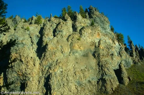
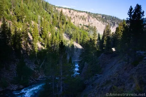
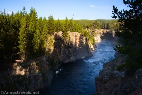
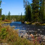
Because the road is one-way, you’ll need to start at the northern terminus, 0.6 miles south of Madison Junction (where US-191 goes west to West Yellowstone). At first, the road is not very exciting; just wandering through the trees. After 0.3 miles, the road begins to follow the Firehole river upstream through the Firehole Canyon. Unfortunately, it’s hard to see much of the canyon due to the trees and the narrowness of the canyon, itself. A convertible would come in handy here.
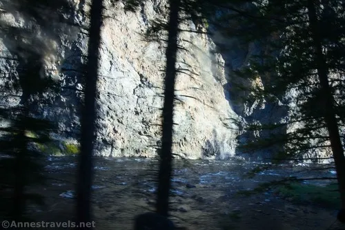
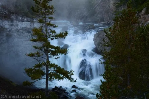
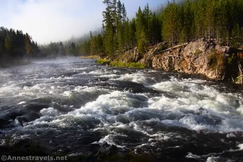
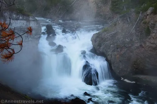
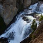
After nearly a mile, a broad turnout on the left (into the mountainside, really) is the parking area for Firehole Falls. This is the most exciting part of the road per me, so I highly recommend a quick stop to get out, cross the road (watch for traffic), and take a photo or two of the falls.
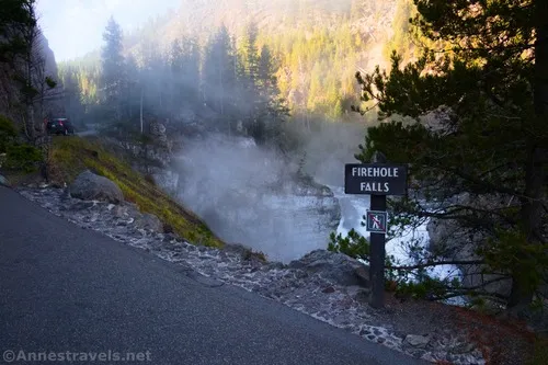
I drove the road in the very early morning, so Firehole Falls was still in shadow. That’s not the worst thing in the world for a photographer, but I’m sure it would be more scenic closer to noon.
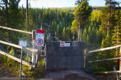
The next site of interest is the Firehole River Swimming Area about 0.9 miles beyond the pulloff for Firehole Falls. This was closed by mid-September, so I can’t say much about it except that there is very limited parking, you’re not allowed to park there off-season, and the stairway down to the swimming area seems to be extremely steep. When it’s open, I hear it’s quite popular and a great place to enjoy the (not too hot) geothermal waters.
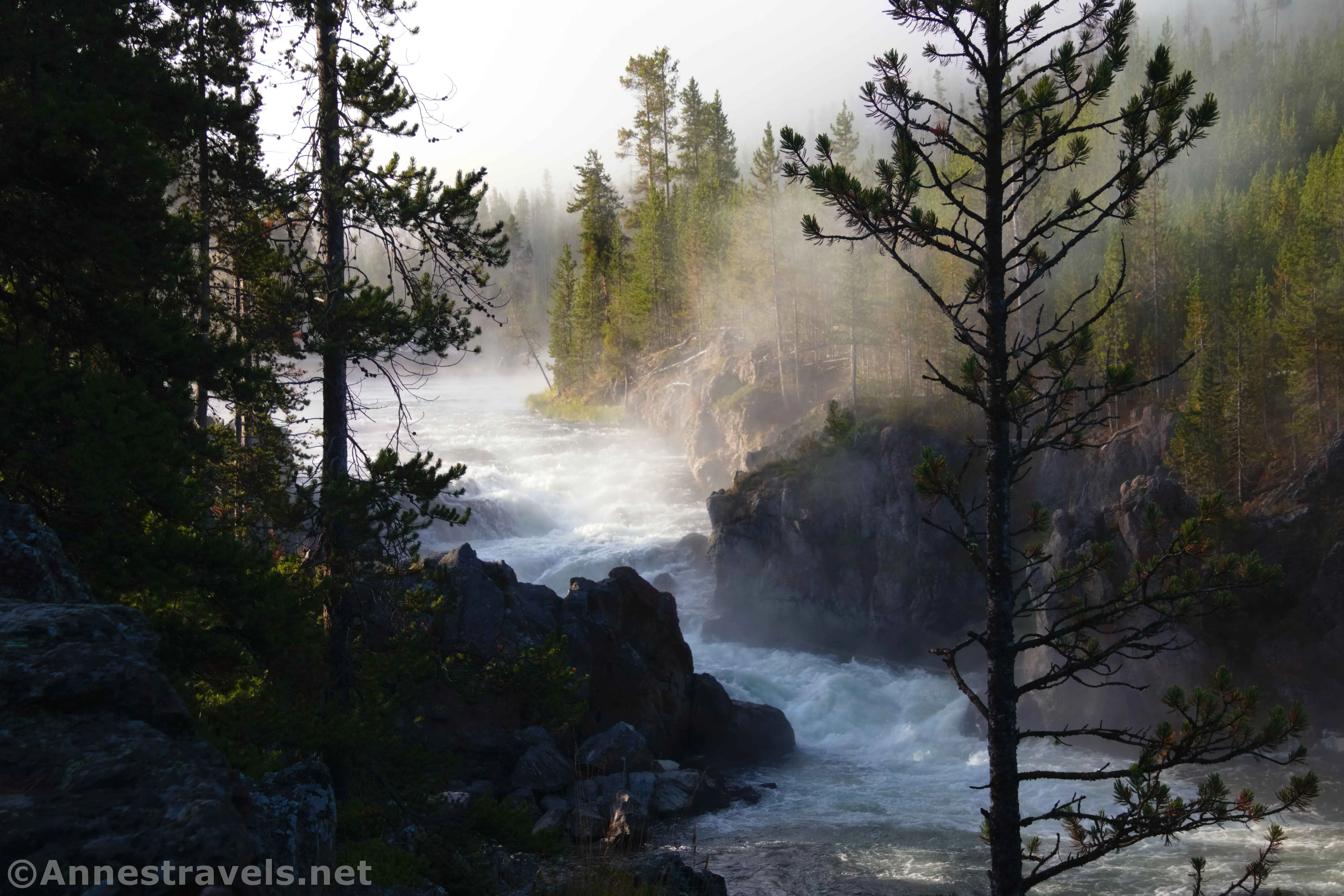
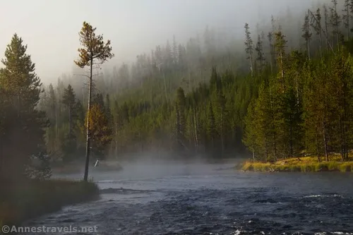
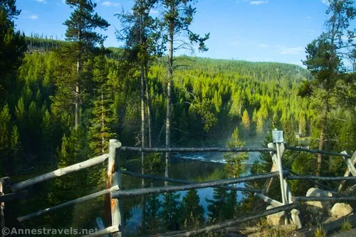
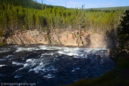
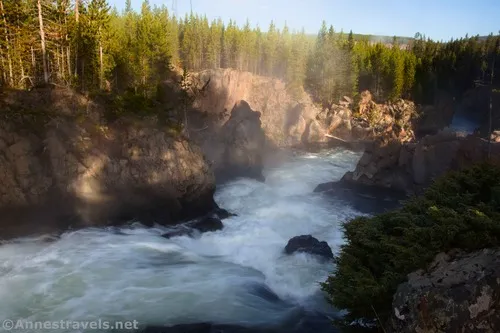
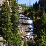
The end of the Firehole Canyon Drive is at mile 2.2. However, if you want one last adventure, pull over in the pulloff just before the scenic drive T’s into the main road (beside the big rocks). By walking upstream on what is obviously an old road, you get to see the Cascades of the Firehole – not really a waterfall per se, but also more than just rapids.
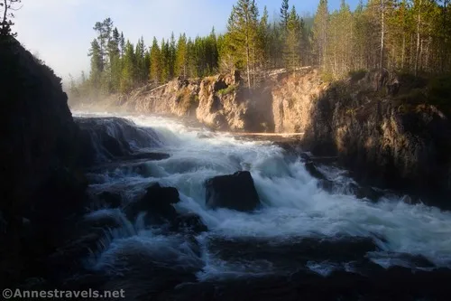
I missed this pulloff, so I turned right onto the main road and then pulled over in the pulloff 0.05 miles upstream. I then walked downstream (on the bank) to see the Cascades.
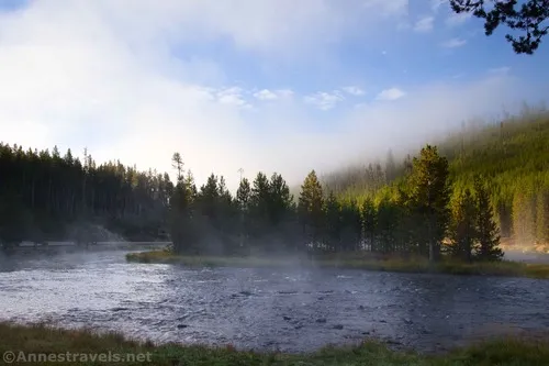
I happened to visit on a chilly morning; Fountain Flat was totally shrouded in mist (which made the Fountain Flat Freight Road quite a fun experience!). The cold air was making mist and water vapor rise off of the warm water in the Firehole River – which created the ethereal look of the Cascades of the Firehole. Amazing!
And that’s what there is to see along the Firehole Canyon Drive! It’s not a lot, but it is pretty and interesting – especially if you get to go swimming, too!
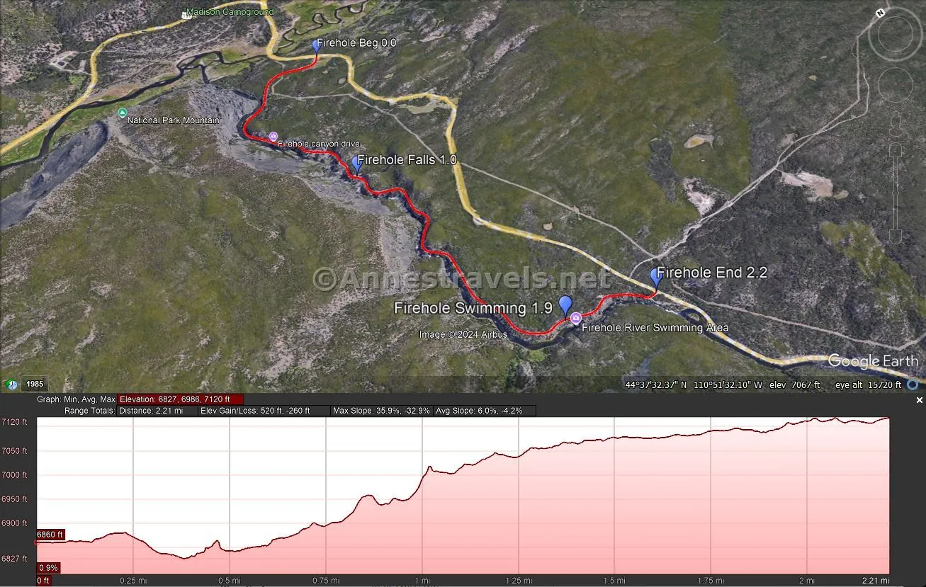
One-way Road Length: 2.2 miles
Elevation Gain: 520ft. gain, 260ft. loss (6,827ft. to 7,120ft.)
Facilities: I hear there is a restroom at the swimming parking lot in-season. Off-season, you’re not allowed to use it.
Fees: $35/vehicle, valid 7 days. America the Beautiful National Parks & Federal Lands passes and Yellowstone Annual Passes are accepted.
Road Notes: The road is narrow and winding, so while I’m not aware of a length restriction, it might be difficult for a very large motorhome or trailer. Please respect the “don’t go beyond this” signs around Firehole Falls. There are a fair number of rapids just below Firehole Falls. Be careful as you explore around the Cascades of the Firehole – the rocks can be slippery and there are no guardrails.
Road 
![]()
Signs ![]()
Scenery ![]()
![]()
Would I go 100 miles out of my way for this? ![]()
![]()
Overall Rating: 
![]()
Firehole Canyon Drive GPS Coordinates
Beginning of Firehole Canyon Drive: 44.6388260°, -110.8586650° (44°38.32956′, -110°51.51990′ / 44°38’19.7736″, -110°51’31.1940″) (6,860ft.) (0.0)
Firehole Falls pulloff: 44.6295830°, -110.8629140° (44°37.77498′, -110°51.77484′ / 44°37’46.4988″, -110°51’46.4904″) (6,969ft.) (1.0)
Firehole River Swimming Area TH: 44.6183080°, -110.8600410° (44°37.09848′, -110°51.60246′ / 44°37’05.9088″, -110°51’36.1476″) (7,092ft.) (1.9)
End of the Firehole Canyon Drive: 44.6172690°, -110.8550550° (44°37.03614′, -110°51.30330′ / 44°37’02.1684″, -110°51’18.1980″) (7,114ft.) (2.2)
The gpx file for the Firehole Canyon Drive can be downloaded – please note that this and the GPS Coordinates are for reference only and should not be used as a sole resource when hiking this trail.
Download GPX File size: 29.1 KB Downloaded 392 times
(Note: I do my best to ensure that all downloads, the webpage, etc. are virus-free and accurate; however, I cannot be held responsible for any damage that might result, including but not limited to loss of data, damages to hardware, harm to users, from use of files, information, etc. from this website. Thanks!)
Getting to the Beginning of the Firehole Canyon Drive
From Madison Junction, drive 0.6 miles south on US-191 (Grand Loop Road). The paved road will be on the right.
From the Old Faithful Exit, drive north for 15.3 miles. The turn onto the paved road will be on the left.
There is a sign announcing the turn onto Firehole Canyon Drive; however, it’s rustic and not extremely noticeable – so keep your eyes open for it!
Today’s Featured Product!
Discover scenic drives, hiking trails for every ability, and the best Yellowstone National Park and Grand Teton National park have to offer with this guide. The map at the beginning is especially good, explaining the different parts of the park for easy reference. Buy your copy here.


One response to “Waterfalls along the Firehole Canyon Drive”
[…] Firehole Canyon Scenic Drive was my first order of business (after breakfast at the Madison Picnic Area) on Day 4. I stopped […]