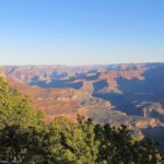
Views from Shoshone Point
The South Rim of Grand Canyon National Park definitely makes it to my “favorite parks in the southwest” list. Any time of day, almost any weather, the Grand Canyon is jaw-dropping. Viewpoints, rim trails, into-the-canyon treks – it’s all a great experience.

The Angel’s Window at Sunrise
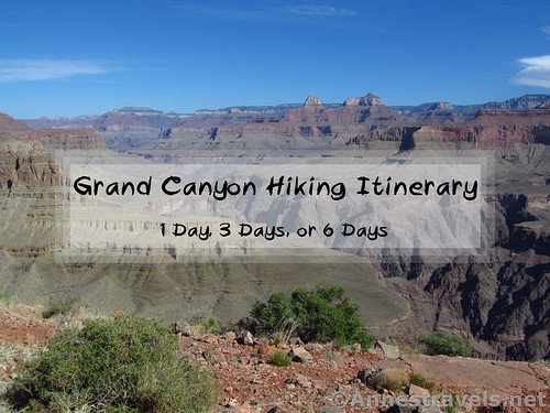
Below I’ve outlined the very best hikes in Grand Canyon National Park – for 1 day, 3 days, or 6 days in the park (South Rim and North Rim).
Grand Canyon Hiker’s Itinerary: One Day (South Rim)

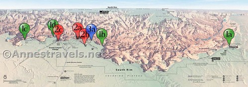
1 Day at the Grand Canyon – (a) Hermit’s Rest Road, (b) South Kaibab Trail, (c) Yavapai Point
In the morning, take the free park shuttle bus to tour the Hermit’s Rest Road (a). Stop at the viewpoints and enjoy the scenery, or hike the Rim Trail between viewpoints (the section between Powell Point and Hopi Point is especially nice).

Views from Hopi Point
Spend the afternoon hiking the South Kaibab Trail (b) – 1.8 miles RT will get you to Ooh Aah Point (well-deserved name), or you can continue down to Cedar Ridge (3 miles RT) or Skeleton Point (6 miles RT).

Ooh Aah Point. Photo Credit NPS/M. Quinn
If possible, catch the sunset from Yavapai Point (c) near the Yavapai Observation Station just west of the Visitor Center.

Sunset at Yavapai Point. Photo credit NPS/M.Quinn
Total Miles Hiked: 1.8 to upwards of 6 miles (depending on how much of the rim trail you hike along the Hermit’s Rest Road)
Grand Canyon Hiker’s Itinerary: Three Days (South Rim)
3 Days at the Grand Canyon – (1a) Desert View, (1b) Shoshone Point, (1c) Hermit’s Rest Road, (1d) Yavapai Point; (2a) Mather Point, (2b) Rim Trail, (2c) Bright Angel Trail; (3a) South Kaibab Trail
Day 1: East to West
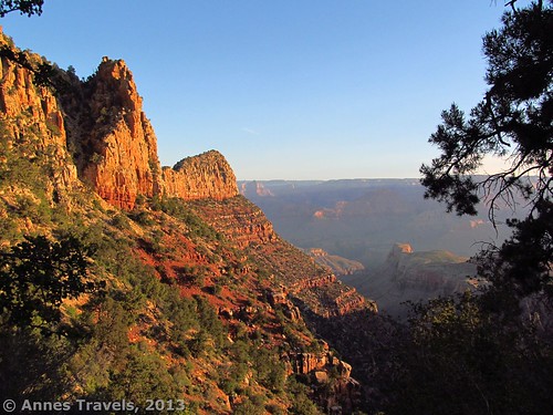
In the morning, take in the Grand Canyon from Desert View Tower and Desert View Point (0.5 miles) (1a), then hike out to Shoshone Point* (2 miles RT) (1b).
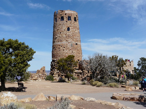
Desert View Tower. Photo credit jb10okie
In the afternoon, tour the Hermit’s Rest Road (1c). Stop at the viewpoints and enjoy the scenery, or hike the Rim Trail between viewpoints (the section between Powell Point and Hopi Point is especially nice).

A small part of the view from Powell Point
Catch the sunset from Hopi Point (1d), Pima Point, or Yavapai Point

Sunset along the trail to Pima Point. Photo credit Jeremy Thompson
Total Miles: 2.5+ miles depending on how much hiking you do on the Rim Trail.
Day 2: Rim Trail Views
Start the day with sunrise at Mather Point (2a).

Views westward from Mather Point shortly after sunrise
Spend the day hiking from Yaki Point to the Bright Angel Trailhead along the Rim Trail (5.1 mile shuttle) (2b). Be sure to check out the various museums along the way. Once at the Bright Angel Trailhead, hike down the Bright Angel Trail (2c) to the first tunnel (at least) before taking the free shuttle bus back to your vehicle.

Tunnel on the Bright Angel Trail. Photo Credit Jared
Total Miles: 5.3-ish miles
The Ambitious Hiker: Instead of hiking the Rim Trail, take the Bright Angel Trail to Plateau Point (2c). At 12.5 miles RT, that’ll test your hiking muscles!
Views from Plateau Point. Photo credit J Brew
Day 3: South Kaibab Trail
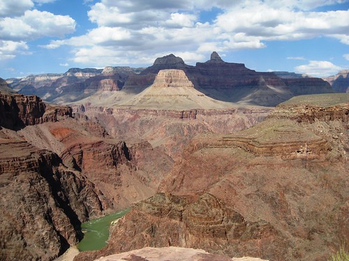
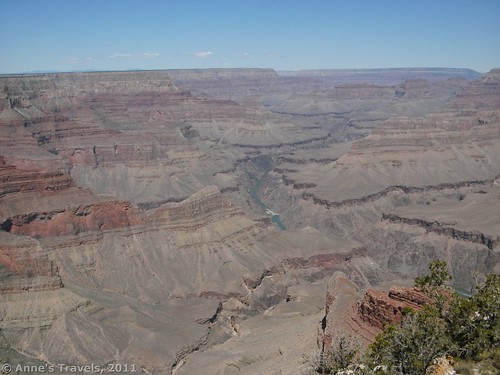
Take the South Kaibab Trail to Skeleton Point (6 miles RT) (3a) for some of the best views in the Grand Canyon!

The Grand Canyon from Skeleton Point
Total Miles: 6.0 miles
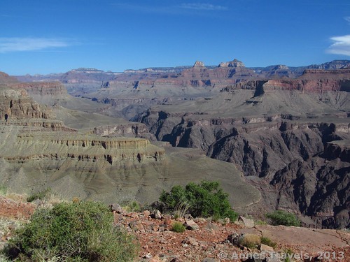
The Ambitious Hiker: Continue down the South Kaibab Trail to the Tipoff (9.4 miles RT). Or if you’re really, really ambitious and love good views, take the Tonto Trail from near the Tipoff west to the Bright Angel Trail. Use the free shuttle to return to your vehicle – you’ll need it after 13.8 miles!
Views near the Tipoff
Grand Canyon Hiker’s Itinerary: Six Days (South Rim)

6 Days at the Grand Canyon; (1a) Desert View, (1b) Grandview Lookout, (1c) Shoshone Point, (1d) Tusayan Ruins; (2a) Grandview Trail; (3a) Mather Point, (3b) Rim Trail; (4a) South Kaibab Trail; (5a) Hermits Rest Road, (5b) Dripping Springs Trail; (6a) Bright Angel Trail
Day 1 (Rest Day): Eastern Grand Canyon
Start your day at the Desert View Lookout Tower and Desert View Point (0.5 miles) (1a) and see the eastern end of the Grand Canyon.

Views from the Desert View Tower. Photo credit NPS
Take the Desert View Road along the rim of the canyon. Follow the dirt road into the national forest to climb the Grandview Fire Tower (1b) (very different views of the canyon than you’ll have elsewhere.)

The Grandview Fire Tower
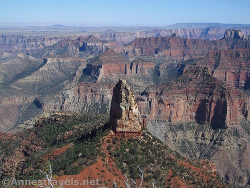
End the day by hiking out to Shoshone Point* (2 miles RT) (1c).

Views from Shoshone Point
Total miles: 2.5 miles (plus a little)
The Ambitious Hiker: Feeling frisky? Don’t do yourself in yet; tomorrow’s hike will test your legs! But if you want a little something more, you can check out the Tusayan Ruins Loop (0.2 mile loop) (1d) west of Desert View and east of the turnoff for the Grandview Fire Tower. Or from the fire tower parking lot, continue on the Vishnu Trail to the Vishnu Overlook (1.1 miles RT; more info here) (1c).

Part of the Tusayan Ruins. Photo credit Lisa Jacobs
Day 2: Grandview Trail to Horseshoe Mesa
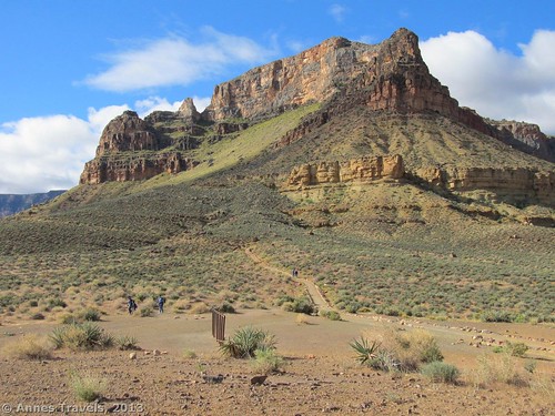
Spend the entire day hiking down the Grandview Trail (2a) and back to the rim (6 miles RT). You’ll want to hike at least as far as the miner’s cabin, but if you’re up to it, the views from an arm of Horseshoe Mesa are incredible (10.0 miles RT).
Sunrise along the Grandview Trail
Total Miles: 6.0 to 10.0 miles
Day 3 (Rest Day): Eastern Rim Trail
Start the day by catching the sunrise at Mather Point (3a).

Sunrise at Mather Point. Photo credit inazakira
Take the free shuttle bus to Yaki Point and hike the Rim Trail (3b) along the rim through Canyon Village (be sure to catch any museums and other points of interest along the way). End your hike wherever (I recommend going at least as far as the Bright Angel Trailhead, a 5.1 mile shuttle hike) and take the shuttle bus back to your vehicle.

Views along the Rim Trail. Photo credit NPS/Michael Quinn
Total Miles: Plus or minus 5.1 miles
Day 4: South Kaibab Trail
Take the South Kaibab Trail to Skeleton Point (6 miles RT) (4a) for some of the best views in the Grand Canyon!

Hikers at Skeleton Point. Photo credit NPS/Michael Quinn
Total Miles: 6.0 miles
The Ambitious Hiker: Continue down the South Kaibab Trail to the Tipoff (9.4 miles RT). Or if you’re really, really ambitious and love good views, take the Tonto Trail from near the Tipoff west to the Bright Angel Trail. Use the free shuttle to return to your vehicle – you’ll need it after 13.8 miles!

Cliffs along the Tonto Trail
Day 5 (Rest Day): Hermits Rest Road
Tour the Hermit’s Rest Road (5a). Stop at the viewpoints and enjoy the scenery, or hike the Rim Trail between viewpoints (the section between Powell Point and Hopi Point is especially nice).
The Colorado River from Mohave Point along the Hermit’s Rest Road
Total Miles: Varies depending on how much of the rim trail you hike
The Ambitious Hiker: From the end of the Hermits Rest Road, take the Hermit Trail down to Dripping Springs (6.4 miles RT; more photos here) (5b).

Dripping Springs Trail Junction. Photo credit NPS/Michael Quinn
Day 6: Bright Angel Trail
Spend the final day hiking the famous Bright Angel Trail (6a). You can adjust the hike to suit your ability (for example, 1.5 Mile Rest House (3 miles RT), 3 Mile Rest House (6 miles RT), or Indian Gardens (9.2 miles RT).

Views from the Bright Angel Trail. Photo credit Sharon Mollerus
Total Miles: 3.0 to 9.2 miles
The Ambitious Hiker: If you can do it, I highly recommend trekking all the way out to Plateau Point (12.5 miles RT) where the views are spectacular!
Visitors at Plateau Point. Photo credit NPS/M.Quinn
Want even more hikes? Check out Ben Adkinson’s book:
Grand Canyon Hiker’s Itinerary: One Day (North Rim)
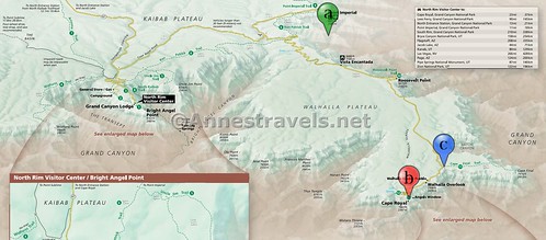
1 Day on the North Rim of the Grand Canyon: (a) Point Imperial, (b) Cape Royal, and (c) Cape Final
Start your tour of the North Rim at Point Imperial (info and photos here) (a). Drive down to, and hike out on, Point Royal (1.1 miles) (b).

Views along the Cape Royal Trail
On your way back up the road, take in the late afternoon views – or better yet, just before sunset views – at Cape Final (4.3 miles) (c).

Views from Cape Final. Photo credit Logan Ward
Total Miles: 5.4 miles
Grand Canyon Hiker’s Itinerary: Three Days (North Rim)

3 Days on the North Rim of the Grand Canyon: (1a) Uncle Jim Trail, (1b) Cape Royal; (2a) Ken Patrick Trail, (2b) Cape Final; (3a) North Kaibab Trail
Day 1: Uncle Jim & Cape Final
Spend the morning hiking the Uncle Jim Trail (4.8 mile loop) (1a).

Part of the view from Uncle Jim Point. Photo credit brewbooks
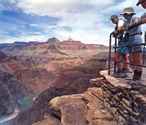
In the afternoon, hike out on Point Royal (1.1 miles) (1b).

Canyon views from the Angels Window on the Cape Royal Trail
Total Miles: 5.9 miles
Day 2: Points & Capes
Visit Point Imperial (info and photos here) (2a) and hike as much of the Ken Patrick Trail (2a) as you’d like (I recommend an out & back of at least 1.3 miles). Leave time to drive down to, and hike out to, Cape Final (4.3 miles) (2b) in time for afternoon views or sunset.

Point Imperial and the canyon from the Ken Patrick Trail
Total Miles: 5.6+ miles
Day 3: North Kaibab Trail
Spend the day hiking the North Kaibab Trail (3a). Popular day hiking destinations include the Supai Tunnel and Coconino Overlook (about 4 miles RT), Roaring Springs (9.5 miles RT), Cottonwood Campground (13.6 miles RT) or (if you’re really ambitious and probably crazy) Ribbon Falls (16.8 miles RT).

Roaring Springs. Photo credit NPS/Michael Quinn
Total Miles: 4 miles to almost 17 miles
Did I miss any fantastic trails in Grand Canyon? Questions? Comment below!
Where to Stay
South Rim
I recommend staying in the Mather Campground or Trailer Village, located in Grand Canyon Village (open all year) or in one of the lodges in the Village (the link also suggests hotels just outside the park). You can also stay in Desert View Campground. More info on the South Rim Campgrounds can be found here. The link also has suggestions for camping outside the park if the campgrounds are full – which is very likely May-September.
Views from an arm of Horseshoe Mesa
North Rim
Because the North Rim is much wilder than the South Rim, your only real choices for lodging at the North Rim are the North Rim Campground or the Grand Canyon Lodge. There are also a few campgrounds located a distance outside the park (see the links).
Point Imperial
Notes & Tips
*Shoshone Point is right next to the event space for weddings and other events. If an event is in progress, please refrain from hiking the trail to allow for privacy the privacy of the guests. Instead, you can hike to the Tusayan Ruins Loop (0.2 mile loop) east of the turnoff for the Grandview Fire Tower. Or from the fire tower parking lot, continue on the Vishnu Trail to the Vishnu Overlook (1.1 miles RT; more info here).
“Days” do not take into account travel time to or from Grand Canyon National Park or eating at restaurants – I’m assuming you’ll be roughing it when it comes to food.
Be flexible with your mileages – climbing back out of the Grand Canyon on the Grandview Trail, South Kaibab Trail, Bright Angel Trail, and the Hermit Trail is a workout!
The South Rim is very crowded during popular times of the year, especially Spring Break and in the summer. Plan extra time to allow for lines while boarding shuttles, alternate camping and lodging options, and use less-traveled trails when possible (for example, the Hermit Trail and the Grandview Trail instead of the Bright Angel Trail (which is almost always crowded for the first mile or so) or the South Kaibab Trail).
Be aware that shuttles and viewpoints will be crowded during the middle of the day (11am to 4pm) and sunset.
Park shuttles are free and are required for the Hermits Rest Road (March 1 through November 30) and the road out to Yaki Point. Shuttles also run through Grand Canyon Village and south to the Tusayan Park & Ride. The shuttles usually run every 15 to 30 minutes on a first-come, first-serve basis and are located about every 1 mile along the Rim Trail. More info on the shuttle buses and bus routes here.