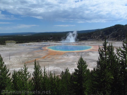
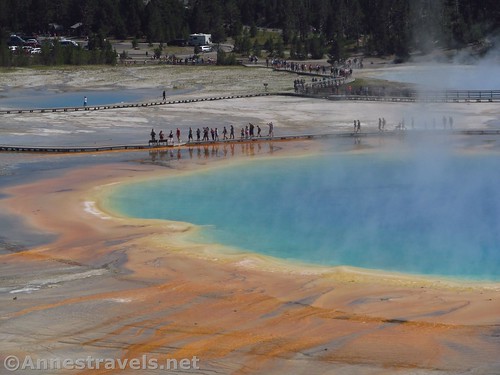
A year or two ago, I read on the Yellowstone National Park Facebook page that the park had just created a new trail – one that looked down on the Grand Prismatic Spring. I’d heard that many people scrambled up the hillside to get a glimpse down on the famous hot spring, but apparently the social trails were so popular that the park service made a real trail for all of us who would be climbing up the hill anyway. I had a chance to check out the new Grand Prismatic Spring Overlook on our cross-country adventure last summer, so I did. And it wasn’t disappointing. I also hiked out to Fairy Falls, since it utilizes the same trail, and that wasn’t disappointing either! So win-win!
Quick Stats
Knowing what famous national parks look like at midday in the summer, we got a very early start to our day, arriving at the parking area for the Fairy Falls Trailhead at about 8am. Already, the small parking area was crowded and the larger parking area was filling up fast. Parking spot secured, we packed up our water bottles and headed down to the bridge.
The trail is an old road, so it’s very wide and easy to walk on (minus that it’s a little bit sandy due to the loose gravel). After almost 0.6 miles, the trail to the Grand Prismatic Spring diverges to the left. As of summer 2019, the trail was so new it didn’t even have a permanent trail sign yet.
Turn left off the old road and ascend via the wide trail up the hill. Faster than I was expecting, about 0.2 miles from the junction, a short spur leads up to the viewing area.
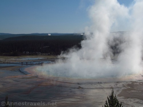
The viewing area is large enough, but at that hour of the morning, it was rightly almost empty. You see, the air is still so cool that the hot water is creating a cloud of water vapor over the Grand Prismatic Spring (the same thing probably happens all day long in the winter). In other words, you couldn’t see anything except a huge cloud of water vapor hanging over what might have been a pool of water.
That not working out, we continued on the trail, which takes you back down to the old road. We turned left and kept walking (it’s easy hiking) another 0.25 miles to the junction with the Fairy Falls Trail. Since we were killing time until the air warmed up a bit, we turned left toward Fairy Falls.
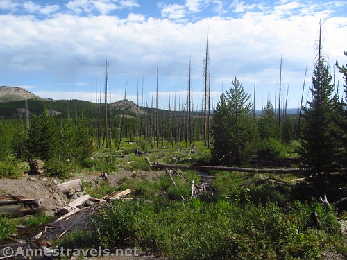
The trail to Fairy Falls isn’t as wide or as easy hiking as the old road (you might actually have to – gasp – gain some elevation!) But it’s still not a difficult hike, especially compared to what we’d been doing in Glacier National Park for the last two weeks. You’ll pass a side trail to a backcountry campsite after about 0.7 miles; continue another 0.8 miles to Fairy Falls.
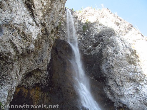
Living so close to many nationally- and internationally-known waterfalls, I wasn’t expecting much from Fairy Falls. So I was very pleasantly surprised to find a dainty waterfall that was high enough to satisfy even this easterner’s waterfall pleasures. One of my group (who’s seen far more waterfalls than I have) even said that Fairy Falls was better than the overlook (I don’t entirely agree, but it was a delightful sight!)
We scrambled up closer to the falls. One of the real benefits of the hour that we visited was that it wasn’t yet overrun with people (it was by the time we left). So we could get close to the falls without feeling like we were ruining other peoples’ pictures.
We had a little snack, then hiked back to the Grand Prismatic Spring Overlook. By this time, the viewpoint was quite a bit busier, but you could actually see the Grand Prismatic Spring. Oh wow! So beautiful!
I went back down the Overlook Trail the long way so I could hike the full extent of the old road (at least between the parking area and the Fairy Falls Trail). One of the great things about the old road is that you can see the Grand Prismatic Spring and drainage channels, but you’re about level with the rim of the spring. It’s not a nice as from the overlook, but it’s still pretty cool.
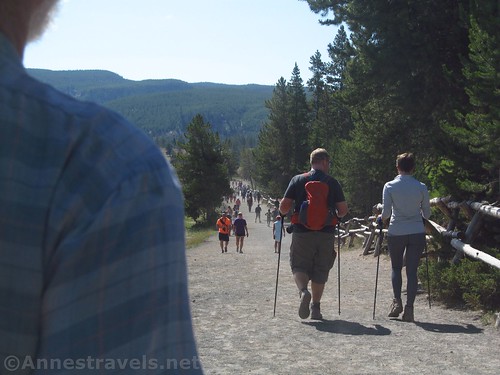
By the time we got back to the parking area, it was jammed packed! In fact, the trail was so crowded that I felt like I was swimming more than hiking. A couple of poor cyclists were trying to ride the old road (it’s one of the few trails in Yellowstone that allows bikes) and they more or less couldn’t because of all the people. So all that to say: Go late in the evening, or go between the early and late morning so that you balance the water vapor vs. people!
Round Trip Length: 1.6 miles to the Grand Prismatic Spring Overlook and back. 5.25 miles out & back to Fairy Falls including the overlook.
Elevation Gain: 118ft. (7,247ft. to 7,365ft.)
Facilities: None
Fees: $35/vehicle/7 days. National Parks & Federal Recreational Lands Passes and Yellowstone Annual Passes also accepted.
Trail Notes: This is a better summer hike if you actually want to see down on the pool – the cool air will create a cloud of water vapor over the spring and block the view. The waterfall is worth seeing if you’re not in a hurry. I have a hard time believing it’s actually 5 miles long since it felt much less. Overall, minus the crowds, this is one terrific hike!
Trail 


Road 


Signs 


Scenery 


Would I go 100 miles out of my way for this? 


Overall Rating: 


GPS Coordinates for the Grand Prismatic Spring Overlook & Fairy Falls
Trailhead: 44.5155167°, -110.8325167° (N44° 30.931′ W110° 49.951′ / 44°30’55.8600″, -110°49’57.0600″) (7,247ft.) (0.0)
Overlook Junction: 44.5227333°, -110.8370333° (N44° 31.364′ W110° 50.222′ / 44°31’21.8400″, -110°50’13.3200″) (7,264ft.) (0.59) (return 4.68)
Grand Prismatic Spring Overlook: 44.5235500°, -110.8401000° (N44° 31.413′ W110° 50.406′ / 44°31’24.7800″, -110°50’24.3600″) (7,365ft.) (0.81)
Overlook Junction #2: 44.5246333°, -110.8409667° (N44° 31.478′ W110° 50.458′ / 44°31’28.6800″, -110°50’27.4800″) (7,272ft.) (0.99) (return 4.44)
Fairy Falls Junction: 44.5271667°, -110.8424333° (N44° 31.630′ W110° 50.546′ / 44°31’37.8000″, -110°50’32.7600″) (7,265ft.) (1.2) (return 4.24)
Campsite Junction (ODI): 44.5250167°, -110.8555333° (N44° 31.501′ W110° 51.332′ / 44°31’30.0600″, -110°51’19.9200″) (7,279ft.) (1.95)
Fairy Falls: 44.5253000°, -110.8696833° (N44° 31.518′ W110° 52.181′ / 44°31’31.0800″, -110°52’10.8600″) (7,299ft.) (2.73)
The gpx file for my hike to the Grand Prismatic Spring Overlook and Fairy Falls can be downloaded – please note that this and the GPS Coordinates are for reference only and should not be used as a sole resource when hiking this trail. Also note that despite the fact that I visited the Grand Prismatic Overlook twice, the GPX file (and the map at the bottom of this post) only visit the overlook once, on the way to Fairy Falls.
Download GPX File size: 63.5 KB Downloaded 341 times
(Note: I do my best to ensure that all downloads, the webpage, etc. are virus-free and accurate; however, I cannot be held responsible for any damage that might result, including but not limited to loss of data, damages to hardware, harm to users, from use of files, information, etc. from this website. Thanks!)
Getting to the Grand Prismatic Overlook & Fairy Falls Trailhead
From Madison Junction, drive south, following signs for Old Faithful. After 11.5 miles, shortly after the Grand Prismatic Spring parking area, turn right, following the sign for Fairy Falls. There is a small parking area to the right and a larger one to the left; however, trailers, busses, and RVs are prohibited due to space constraints.
From West Thumb, drive west (north), following signs for Old Faithful. After almost 22 miles (you will pass by Old Faithful before this), turn left, following the sign for Fairy Falls. There is a small parking area to the right and a larger one to the left; however, trailers, buses, and RVs are prohibited due to space constraints.

Visual trail map and elevation profile for the trail to the Grand Prismatic Spring Overlook and Fairy Falls
Zoom map out to browse nearby hikes & places of interest
This Week’s Featured Product!
Love views? Then check out this guide featuring some of the best views in Wyoming! A long section details Yellowstone National Park, with another long section on Grand Teton National Park.
(adsbygoogle = window.adsbygoogle || []).push({});









Pingback: Sneak Peak: The Beauty of Western Montana! - Anne's Travels