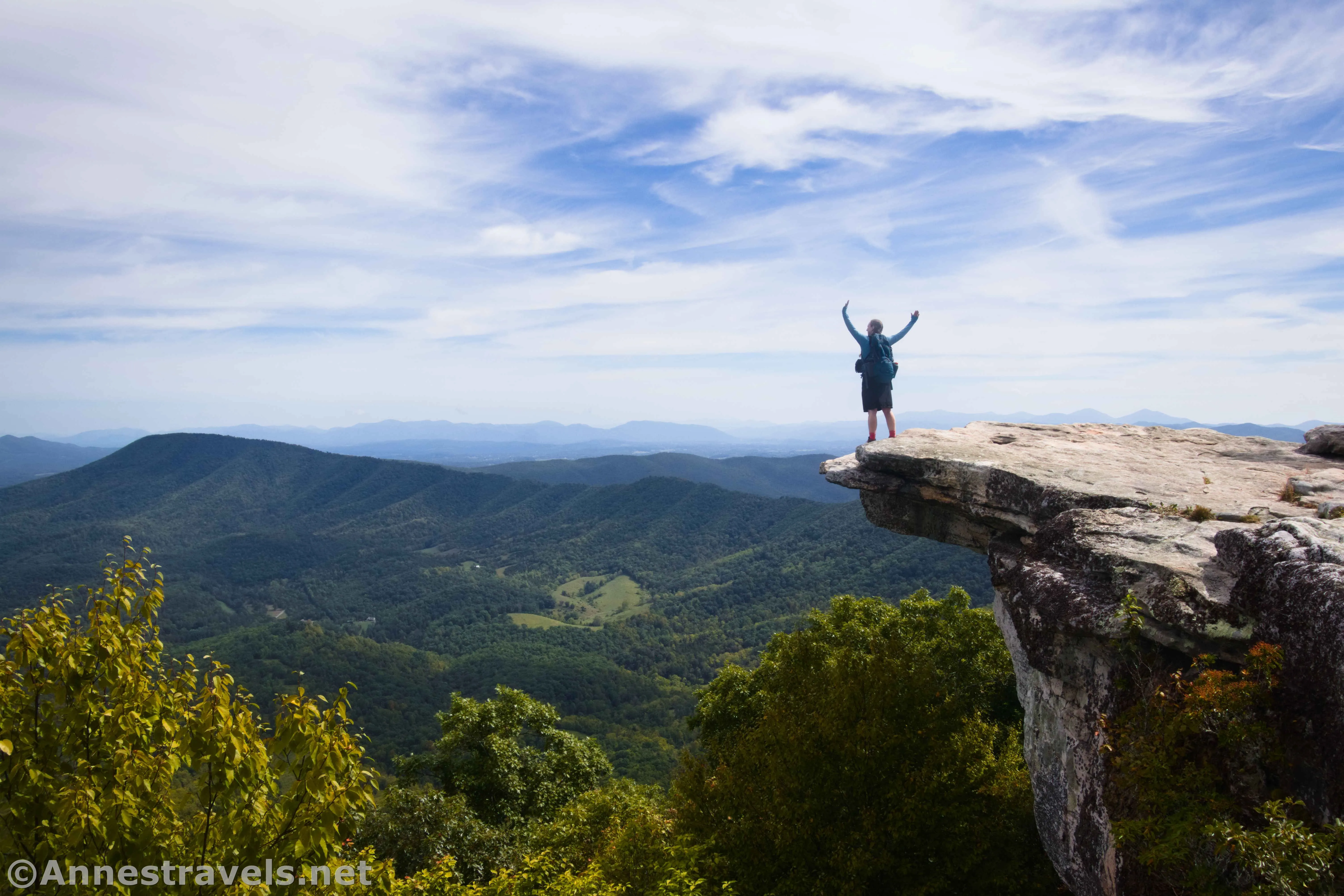
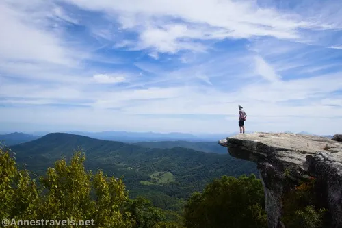
They say that McAfee Knob is the most-photographed point of the Appalachian Trail. Even thru-hikers stop to get their picture taken on the little point of rock that hangs over the edge of the cliff face – it’s almost a rite of passage. Add to that the dozens of day hikers every week who ascend McAfee Knob to see the view – and of course take a photo of themselves on… well, you get the idea. I decided to see what the hype was all about a couple of weeks ago when I happened to be hiking in the Blue Ridge Mountains around Roanoke, Virginia. Answer: It’s a good (if steep) trail, a pretty view, and if you get there early, you might just have the view to yourself for a while!
Quick Stats
Because of my schedule, I ended up hiking McAfee Knob midweek in September. I hoped that this would cut down a bit on the crowds (and I’d say, to some extent, I succeeded). The other good (or bad) thing about this time of year is that there aren’t many thru-hikers out and about, so that also limits the sheer number of people in the area. The official parking area is closed for construction this year (2024), so I ended up having to park on the shoulder of Old Catawba Road, which is just downhill (on the Roanoke side) of the official parking area. This also acts as overflow parking, as the parking area isn’t even close to big enough for the demand. Just be sure to follow the very confusing parking signs – one side of the road will say “No Parking,” and the other will say “No Parking except between signs” (with the last three words in minuscule letters). Really, most of the road allows parking on only one side or the other – so you just need to make sure you’re parking on the correct side of the road.
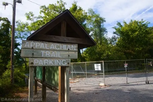
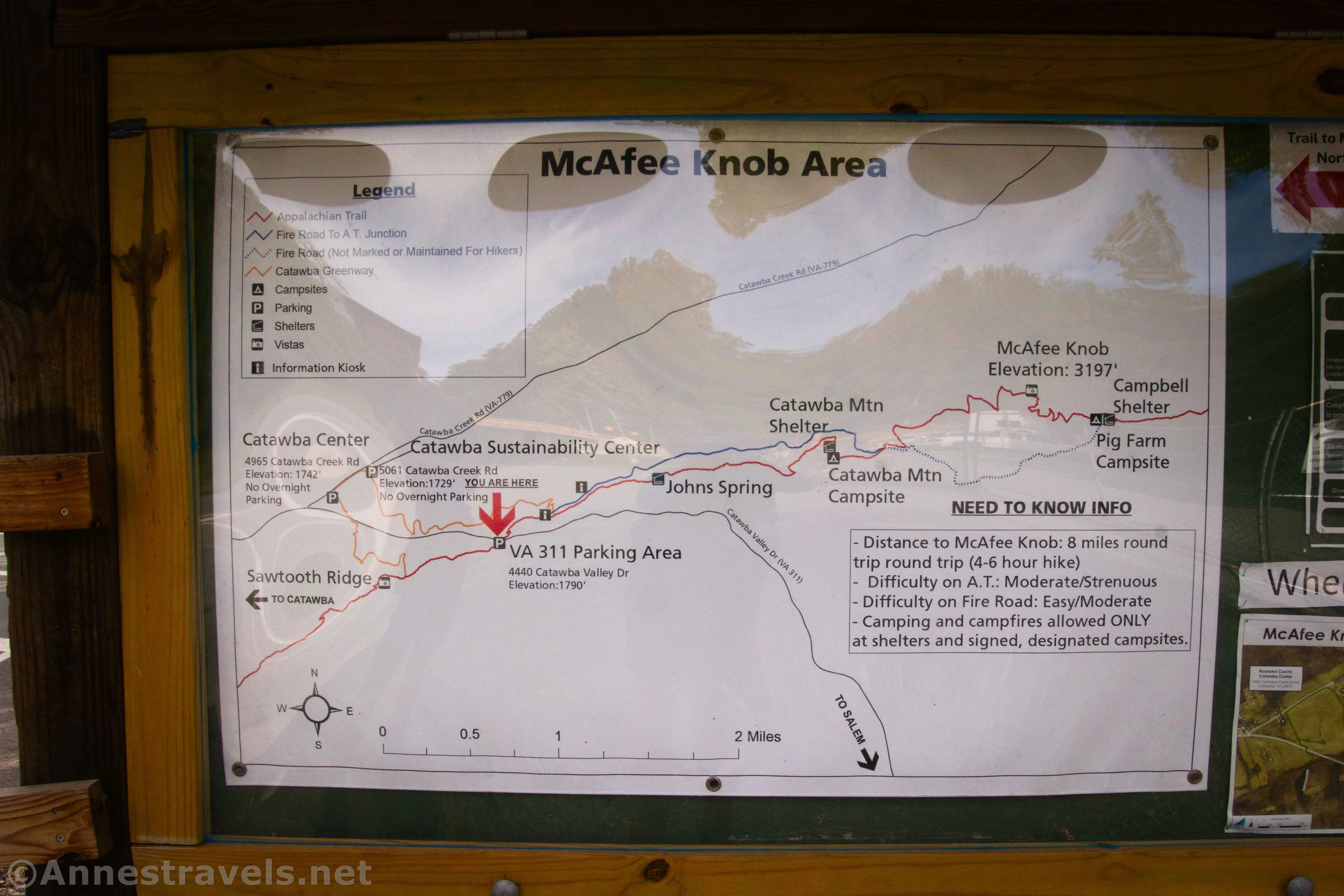
From Old Catawba Road, we hiked back up to Hwy 311, turned left, and walked to the kiosk in the parking area. There is a map and other useful information. Then, cross the road (after 2024, you should be able to use the pedestrian bridge at the other end of the parking area – a massive improvement, as Hwy 311 is very busy, and also the reason for the parking area closure) and begin up the Appalachian Trail North.
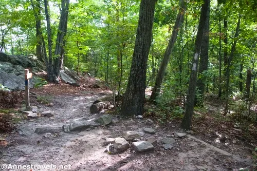
After 0.3 miles, you will come to a major junction. The old fire road goes left, while going right will take you to a kiosk and to continue on the Appalachian Trail. You’re welcome to go either way, but I opted to turn right. The area by the kiosk had a peek-a-boo view back to the valley.
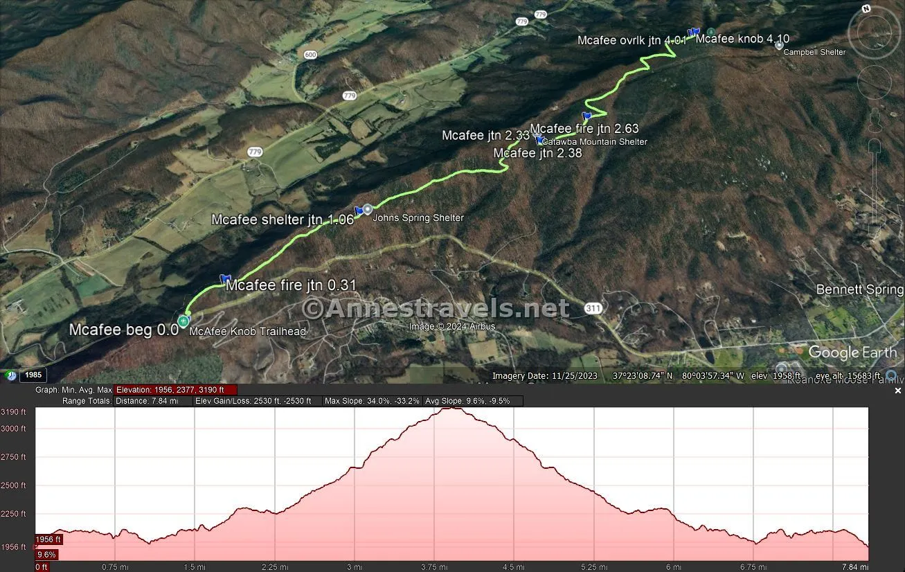
The trail seems to descend quite a bit over the next 2 miles, but I’m not certain that it wasn’t just my imagination – because it didn’t seem to be all that terribly uphill on the way back. The more honest report is that it rolls to a shelter on the right at mile 1.0, then continues to roll to a confusing junction 1.3 miles later. While most of the junctions specifically mention McAfee Knob – and usually also the AT – this one only has signs for the shelter and campsites. Follow the sign for the campsites.
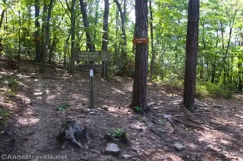
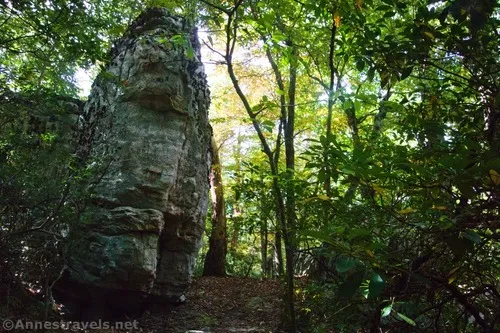
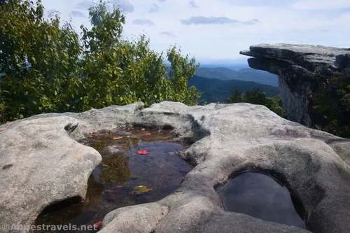
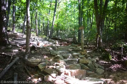
A short distance later, you’ll see a much more helpful sign with all kinds of mileages on it. You want to turn left here (straight would take you into the campsites) toward McAfee Knob and AT North. After this, the trail really does begin a steady uphill ascent, crossing the old fire road again at mile 2.6. Walk straight across the road and pick up the trail to eventually enter an area with huge rocks. Neat!
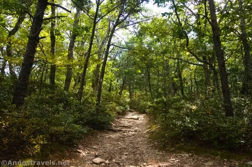
At last, about 3.8 miles from the trailhead, the forest (which has been fairly thick up to this point) begins to thin, and the trees to be shorter. This is good news, because it means that you’re approaching the top of McAfee Knob.
At mile 4.0, you’ll enter a sudden open area that’s really just a big, flat rock under your feet. Turn left here (there is a blue blaze painted on the rock and a sign for the “overlook”). The short path will lead you out to the famous McAfee Knob viewpoint!
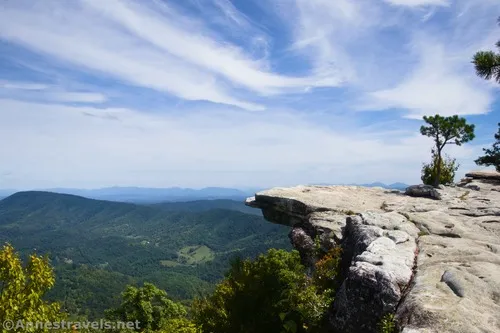
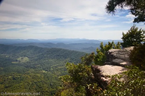
The famous view is just to your right (if you’re facing the view). I arrived about 11:20am, and at that point, the overhanging rock didn’t have the best lighting. It was much better by the time we left about 12:30pm. We took pictures anyway, even though the lighting would improve later (if the reports I’d read were any indication, we wanted to get pictures before the hoards arrived!)
At least one couple beat us to the top, and a single guy (@ross_b_permanent_vacation on Instagram) wasn’t far behind us. We all pretty much ignored each other and enjoyed the quiet views down over the valley, while giving each other space to take pictures.
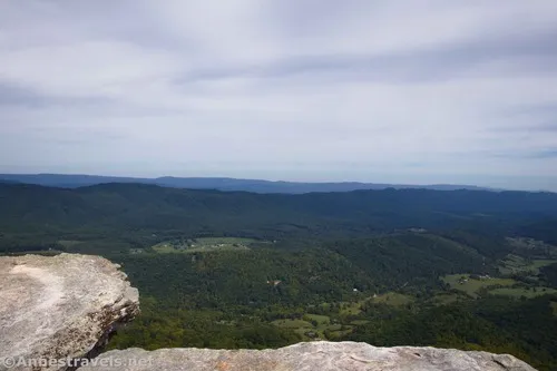
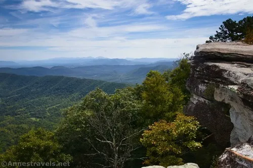
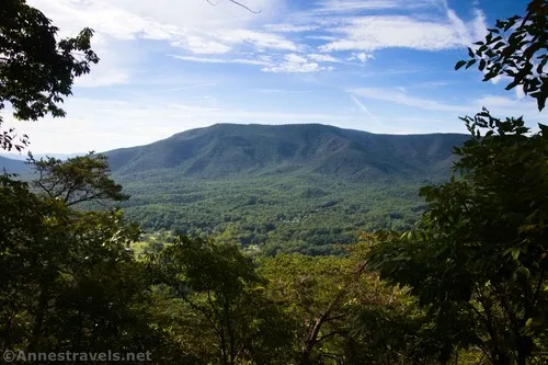
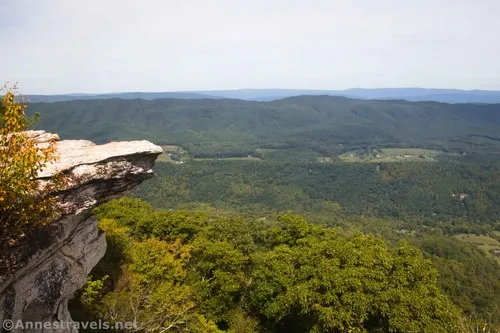
And what views there are! Yes, the famous McAfee Knob photos are taken near where the trail exits the woods. But if you head right, along the top of the cliff, the path and cliff extend for quite some distance (maybe a quarter mile). The further you go, the quieter it will probably be. At the very least, I found a mini-McAfee overhanging rock, and at the very end, we could see the Roanoke Airport.
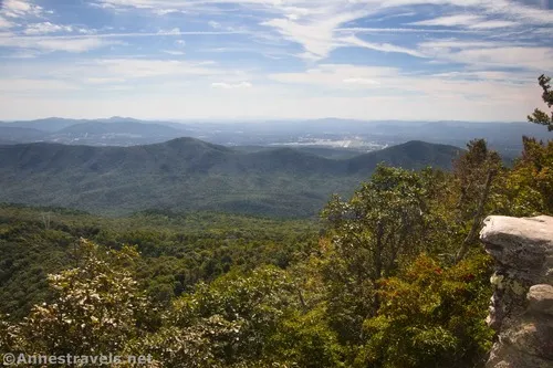
But the best views are down the valley. We ate lunch and enjoyed the view. BTW – walking out onto the overhanging rock isn’t all that scary. Climbing Dragon’s Tooth the next day was much worse in terms of feeling the exposure. Part of the thing with McAfee Knob is that there is a lot of cliff behind what appears to be the end of the overhang in the photos!
By the time we came back, things were beginning to be much more crowded. I probably passed half a dozen people in the space between the famous overhang and the flat rock at the junction with the AT. One guy offered to take our photo on the overhang (the light was much better by 12:30pm!), and we accepted. I’m so glad we did – that guy knew what he was doing and all of the best angles!
The trip down was unexciting and fairly peaceful. I should probably have taken the fire road, but I decided to just skip that on this trip… even though it would make for a more peaceful and likely less rolling loop part of the hike!
Round Trip Trail Length: 8.25 miles
Elevation Gain: 2,530ft. (1,956ft. to 3,190ft.)
Facilities: None
Fees: None
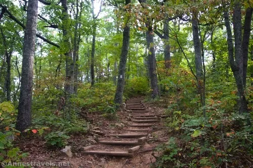
Trail Notes: On summer weekends, McAfee Knob is so crowded that you’re lucky if you can get a photo without someone in it. I highly recommend the off-season and during the week if you can. Fall colors would be amazing. You’re hiking on the Appalachian Trail for 99% of the hike, so just follow the white blazes. The trail is well-maintained and easy to follow. Be sure to park legally – no parking is allowed along Hwy 311, and the signs indicate where you can park along Old Catawba Road. I hear there is ample parking down Hwy 311 at the Sustainability Center, but it adds significant mileage to the overall hike. There is poison ivy along the trail, but it’s very easy to avoid since the trail is wide.
Trail 
![]()
![]()
Road
Signs ![]()
Scenery ![]()
Would I go 100 miles out of my way for this? ![]()
Overall Rating: ![]()
GPS Coordinates for McAfee Knob
TH (signboard): 37.3801820°, -080.0891740° (37°22.81092′, -080°05.35044′ / 37°22’48.6552″, -080°05’21.0264″) (1,953ft.) (0.0)
Fire Road Junction: 37.3821740°, -080.0858160° (37°22.93044′, -080°05.14896′ / 37°22’55.8264″, -080°05’08.9376″) (2,098ft.) (0.31)
Shelter Junction (Johns Spring Shelter): 37.3853370°, -080.0743140° (37°23.12022′, -080°04.45884′ / 37°23’07.2132″, -080°04’27.5304″) (1,951ft.) (1.06)
Shelter Junction (Catawba Mountain Shelter): 37.3884950°, -080.0567560° (37°23.30970′, -080°03.40536′ / 37°23’18.5820″, -080°03’24.3216″) (2,199ft.) (2.33)
Campground Junction: 37.3874540°, -080.0567850° (37°23.24724′, -080°03.40710′ / 37°23’14.8344″, -080°03’24.4260″) (2,203ft.) (2.38)
Cross Fire Road: 37.3882810°, -080.0517030° (37°23.29686′, -080°03.10218′ / 37°23’17.8116″, -080°03’06.1308″) (2,383ft.) (2.63)
McAfee Knob Overlook Junction: 37.3928260°, -080.0377330° (37°23.56956′, -080°02.26398′ / 37°23’34.1736″, -080°02’15.8388″) (3,159ft.) (4.01)
McAfee Knob (overhanging rock): 37.3929960°, -080.0371700° (37°23.57976′, -080°02.23020′ / 37°23’34.7856″, -080°02’13.8120″) (3,130ft.) (4.10)
(I did not include the walk along the cliffs)
End (signboard): 37.3802010°, -080.0891810° (37°22.81206′, -080°05.35086′ / 37°22’48.7236″, -080°05’21.0516″) (1,954ft.) (8.28)
The gpx file for McAfee Knob can be downloaded – please note that this and the GPS Coordinates are for reference only and should not be used as a sole resource when hiking this trail.
Download GPX File size: 101.4 KB Downloaded 290 times
(Note: I do my best to ensure that all downloads, the webpage, etc. are virus-free and accurate; however, I cannot be held responsible for any damage that might result, including but not limited to loss of data, damages to hardware, harm to users, from use of files, information, etc. from this website. Thanks!)
Getting to the McAfee Knob Trailhead
From I-81, take Exit 141 toward VA-419 and VA-311 N and Salem/New Castle. At the end of the exit ramp, turn left (if coming from I-81S) or right (if coming from I-81N) and drive 0.4 miles. In the traffic circle, use the far-right lane (that never really gets into the traffic circle at all) to turn right onto VA-311. The parking area will be on your left after 5.5 miles.
Today’s Featured Product!
Showcasing some of the best scenery in southern Virginia, this guide takes you to 40 viewpoints, gorges, waterfalls, mountains, and more. Buy your copy here!