

The Monument Geyser Basin in central Yellowstone National Park was heralded to me as a great adventure. Here you could enjoy a geyser basin in its natural state, without crowds or even boardwalks! Unfortunately, I’m afraid it was a bit oversold. While it isn’t exactly popular, and there aren’t any boardwalks, it’s also not exactly a premier example of geothermal activity in Yellowstone. However, I did enjoy it enough to post about it (here goes!), and there is one type of feature that I have not seen in any other of Yellowstone’s more easily accessible geothermal areas – smoking stacks!
Quick Stats

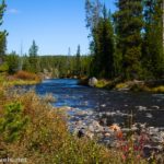
The trail begins at a small, marked pulloff north of Beryl Spring just south of where the park road crosses the Gibbon River. We started on a misty morning, so the ambiance as the path follows the river, just inside a fringe of fir trees, was excellent.

After 0.4 miles, the trail turns left, away from the river, and begins a steep ascent. For the most part, the path is dirt and not too hard to climb, but one section is on exposed rock. This was a little trickier (it’s slippery, especially with the small stones on it), but we got there.

As we climbed, the sun burned away the mist. By the time we broke out of the trees for the first time – on the rim of Monument Basin, about 1.2 miles from the trailhead – the sun was shining brightly. Just before the trail breaks out of the trees, a small, unofficial viewpoint on the left allows you to see down into the valley below.

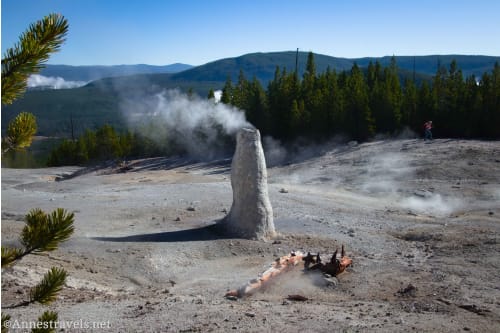
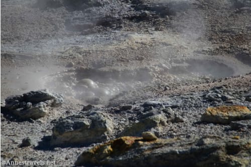
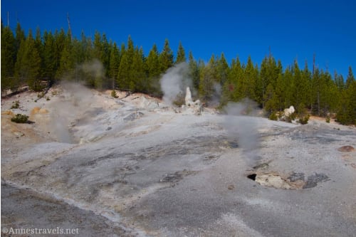
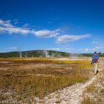
You’ll know you’ve arrived at Monument Basin when the ground on the left becomes white and treeless. A few smoking holes in the ground are also good indicators that you’re there.

The viewpoint is about 1.3 miles from the trailhead. From here, you can see most of what Monument Basin has to offer: A few smoking holes and at least three cool tall, thin “smokestacks” with water vapor puffing out in a sinister – or contented – manner.

I did walk a little further to near the far northern end of the basin, where a drainage channel goes down the hillside and the trees begin again. Remember to stay on the east (trail) side of the basin (near the trees) and do not enter the geothermal area.

Retrace your steps to the parking area. It’s not a very long or complicated trail, but if you want to see the smoking stacks, it’s a good option to leave behind the crowds!

Note: Not being satisfied with the views, I tried to enter the trees and hike around the basin. Don’t do it!! For one thing, you don’t get all that better views, and for another, there’s no way to safely circle the basin. Honest, staying on the trail is the better way to go.

Round Trip Trail Length: About 2.7 miles
Elevation Gain: 897ft. (7,338ft. to 7,987ft.)
Facilities: None
Fees: $35/vehicle, valid 7 days. America the Beautiful National Parks & Federal Lands Passes and Yellowstone Annual Passes are accepted.
Trail Notes: Remember to stay on the trail and do not enter the geothermal area. Also, don’t try going around the back of the basin; there is no way to safely loop back to the trail. If you want a better, mostly-uncrowded, boardwalk-less geothermal experience, try the Sentinel Meadows Loop, which is longer but has less elevation gain and some great views.
Trail 
![]()
![]()
Road ![]()
Signs ![]()
![]()
Scenery ![]()
![]()
Would I go 100 miles out of my way for this? ![]()
![]()
![]()
Overall Rating: ![]()
![]()
GPS Coordinates for the Monument Geyser Basin
TH: 44.6838100°, -110.7446720° (44°41.02860′, -110°44.68032′ / 44°41’01.7160″, -110°44’40.8192″) (7,334ft.) (0.0)
Monument Basin: 44.6843460°, -110.7533630° (44°41.06076′, -110°45.20178′ / 44°41’03.6456″, -110°45’12.1068″) (7,972ft.) (1.33)
End at TH: 44.6838470°, -110.7446170° (44°41.03082′, -110°44.67702′ / 44°41’01.8492″, -110°44’40.6212″) (7,332ft.) (3.22)

The gpx file for the Monument Geyser Basin Trail can be downloaded – please note that this and the GPS Coordinates are for reference only and should not be used as a sole resource when hiking this trail.
Download GPX File size: 36.0 KB Downloaded 68 times
(Note: I do my best to ensure that all downloads, the webpage, etc. are virus-free and accurate; however, I cannot be held responsible for any damage that might result, including but not limited to loss of data, damages to hardware, harm to users, from use of files, information, etc. from this website. Thanks!)
Getting to the Monument Geyser Basin Trailhead
From Madison Junction, drive north (toward Norris and Canyon) on the main park road. The Monument Basin Trailhead will be on the left after 8.6 miles, just before the road crosses over the Gibbon River.

From Norris Junction, head south (toward Madison and Old Faithful) on the main park road. The Monument Basin Trailhead will be on the right after 4.7 miles, just after crossing over the Gibbon River.

More Hikes in Yellowstone!
Looking for more hikes in Yellowstone that are off the beaten path? Try out this guide!


Pingback: How I Hiked 100 Miles in Yellowstone National Park in 11 Days – Anne's Travels