
Very frequently, when I leave the traditional trails behind on a whim, it would have been better for me to stay on the traditional trail. Not always, of course – I’ve found some very fun and interesting stuff along the way – but usually not without significant wayfinding, bushwhacking, or worse. Striking off to follow an old road that began from a social trail above the Emmons Moraine Trail didn’t seem like all that great an idea when I thought about it logically. But it turned out great, so I’ll tell you how I did it – and then how I came down the Climber’s Trail after some outstanding vistas of the Emmons Glacier!
Quick Stats
We started out the morning by hiking up the Glacier Basin Trail to the Emmons Moraine Trail (I’ll do a quick writeup of it here, but if you want more info, click here. Follow the Emmons Moraine Trail up until you come to the “Trail Not Maintained Beyond This Point” sign. Then continue up the trail, which will eventually turn away from the rim of the hill (turn right, in other words) through stunted pine trees. Ignore all the social trails and stay on the main trail. It will eventually take you up to the rim again (albeit much higher up, and with a much better view of the Emmons Glacier), but before it reaches the rim, you’ll pass an old road striking off on the right about 0.5 miles beyond the “trail not maintained” sign.
The old road immediately enters the forest. There are a fair number of trees down across the embankment at this point as it rises up to curve around the shoulder of the hill. Thankfully, they’re not hard to duck under or scramble across.
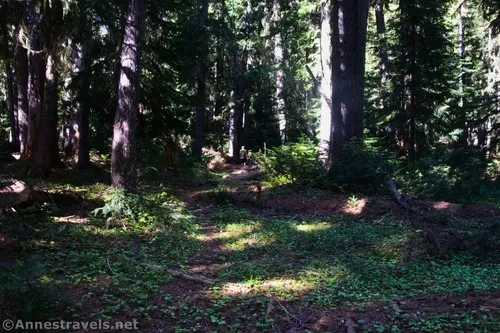
As the old road continues into the forest, it becomes vaguer. Thankfully, I had someone in my group who is exceedingly good at finding trails where there are none (or not much sign of one). We could also follow the line of brand-new trees or (more frequently) cut-off logs that were missing their stumps (or cut-off stumps that were missing their logs). Between these two indicators, we rarely lost the trail for more than a minute or so.
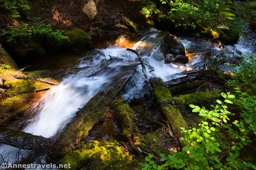
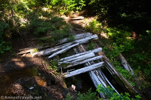
However, before things got really vague, we crossed three ravines that once were spanned with bridges. Each bridge was more intact than the last. It was fascinating to look at the construction, even though all three had collapsed sometime in the past (I’ll blame heavy snow years for that). Thankfully, in mid-July, the streams were easy enough to cross without getting our feet wet.
We headed up, following the remains of the road, for nearly a mile (from leaving the Emmons Moraine social trail). At this point, it was easy to scramble down to the Inter Fork and sit on boulders to eat a snack.
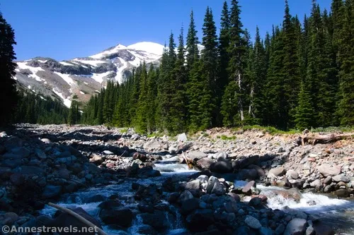
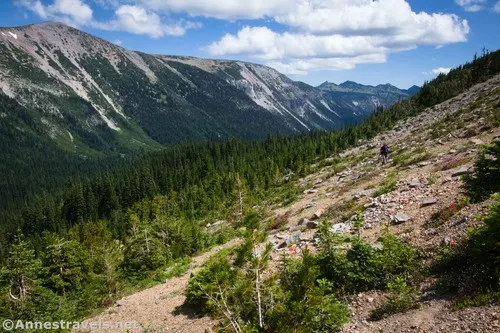
What we should have done at this point was to follow the Inter Fork uphill (left). The streambed was rocky but definitely not full of water. However, in our zeal to follow the old road, we tried to locate it above where we’d eaten. However, it pretty much vanished. I still don’t know exactly where it went, not because we lost it, but because I think it might have ended (or fallen into the streambed, which had already happened a couple of times before this). We followed deer and elk trails for a while, but that wasn’t working, so I simply struck upward. There had to be the top of the ridge, sooner or later!
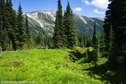
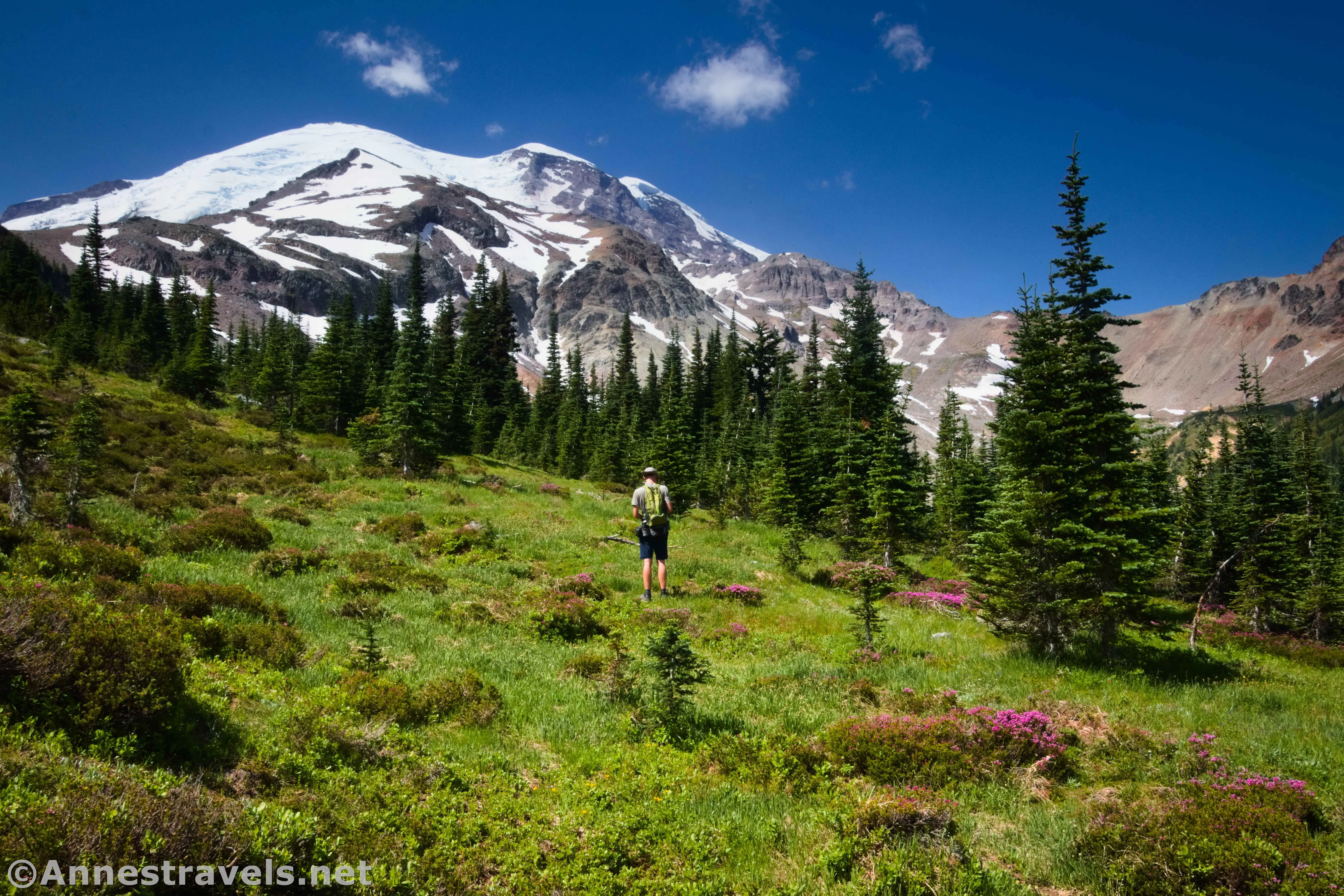
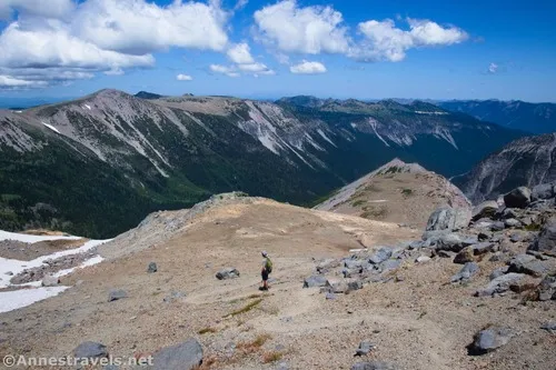
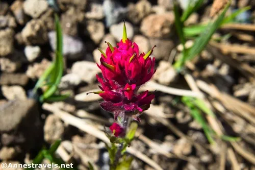
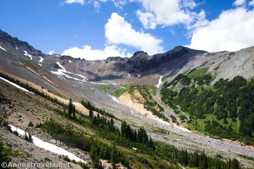
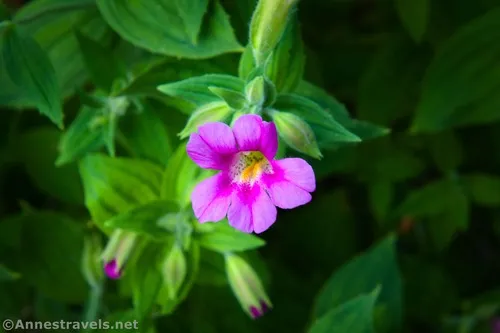
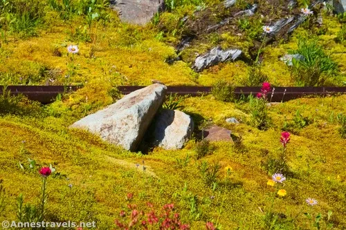
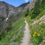
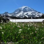
We broke treeline a very steep and forest-y 0.3 miles after leaving the Inter Fork. The really neat thing was that we ended up in a meadow – I love meadows to begin with, but this one had some wildflowers and a spectacular view of Mt. Rainier!
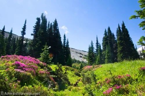
At this point, we headed for Mt. Rainier. Meadows (try not to trample anything!) and sheep trails took us to scree. I’m no lover of scree, and this was an incredibly steep scree slope – the kind that’s hard to walk across because the scree is very likely to fall down the mountainside, and you with it! So as soon as I came to some larger rocks (that were mostly steady), I headed straight up to where I hoped I could find a slightly less steep slope. Even as it was, I ended up having to use my trekking poles as extra limbs to keep myself from falling as I continued toward Mt. Rainier.
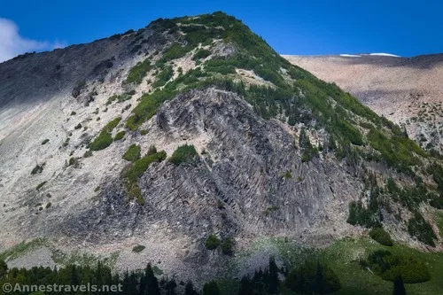
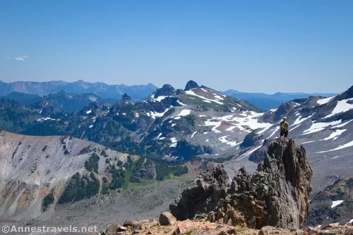
And then – oh, thank goodness – I hit the Climber’s Trail. (We knew it was there and were heading for it because we’d seen it from Burroughs Mountain the day before.) Mind you, the Climber’s Trail is no joke. It’s tiny little switchbacks made of scree that see far too much traffic (I think just existing might be too much traffic, but the number of hikers mean that the rocks slide worse).
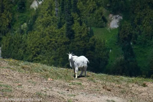
The bottom of the trail is much worse than the top, which is steep but not quite so scree-filled, especially as you approach the ridgeline. I trekked my way up; I’d come this far, and I was going to see what was over that ridge! As I climbed, I spotted a mountain goat.
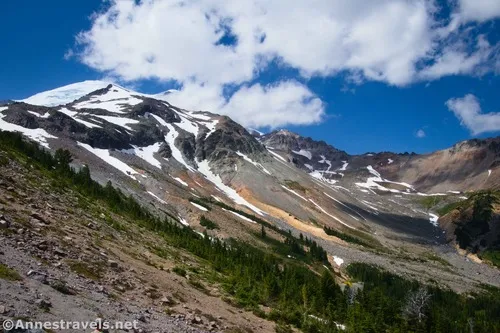
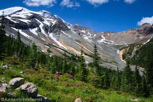
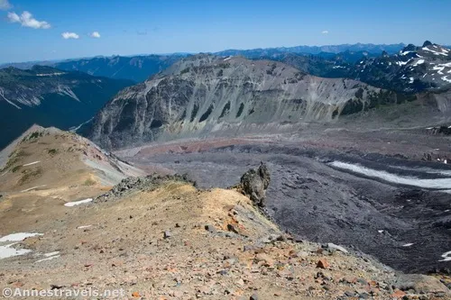
At last, pop up over the top of the ridge – and be ready to let your jaw drop at the view!
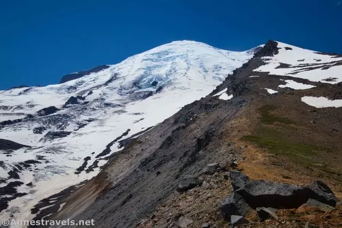
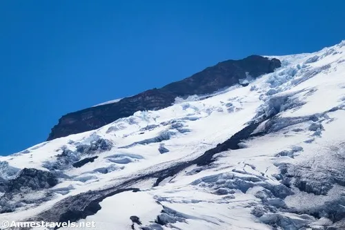
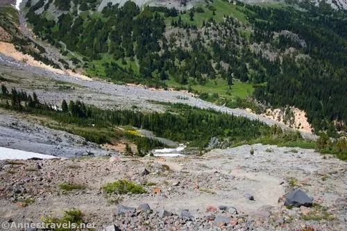
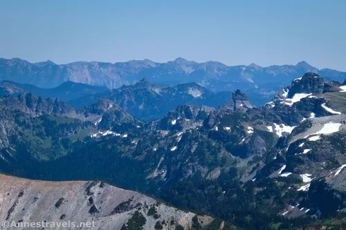
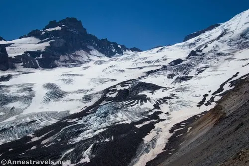
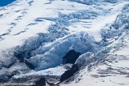
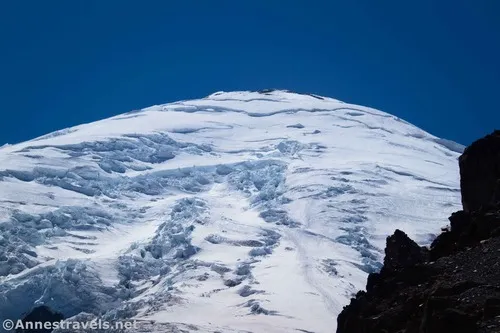
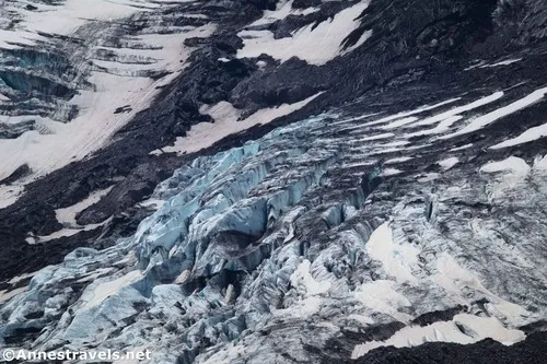
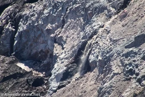
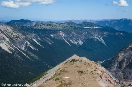
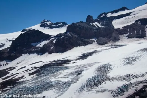
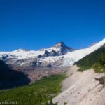
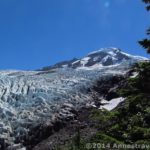
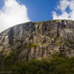
At this point, you’re above the Emmons Glacier as it rises up the side of Mt. Rainier. Once you finally lift your eyes from the hundreds of crevasses (plus a waterfall or two), you get to look out on the mountains to the south and easy of Mt. Rainier. Totally wow!!
I couldn’t get a decent photo; it’s just too wide a view.
Of course, if you want an easier way to access this point, you could take the Glacier Basin up to just beyond Glacier Basin Camp and the “Trail Not Maintained Beyond This Point” sign (yes, it has one, too) and then (less than a tenth of a mile later) take a left on a well-trodden social trail that drops you down to the streambed. Cross over the Inter Fork (not as easy as it sounds, even in mid-July – that water is swift, and the stream just too wide to jump across), relocate the Climber’s Trail, and then hike up to the ridgeline. That would bring you in at the ridgeline about mile 4 (but maybe slightly more than that).
You’re welcome to turn around here, but as we finished a snack (really lunch, because we didn’t eat lunch that day) several rangers crested the ridge. They were on their way up to Camp Schurman and had decided to take the Climbers Trail route instead of hiking up the Inter Glacier. They raved about the views higher up, so guess what – we continued up along the ridgeline!
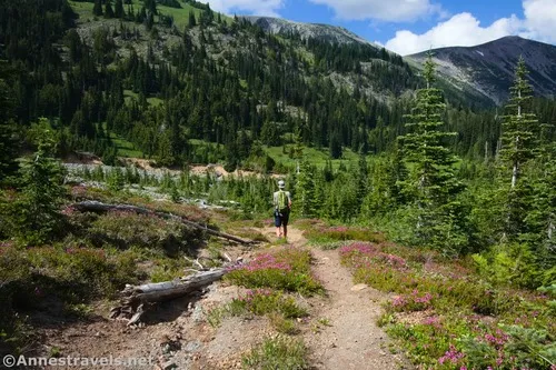
The trail continues to be social-esque but generally pretty good for a bit, then it deteriorates in the rock and scree. It’s still fairly easy to follow (and not terribly slippery) all of the 0.6 miles up to where we turned around.
By the time I turned around, a large rib of rock was blocking part of the view of Mt. Rainier. I believe the trail turns inland at this point to avoid the summit of Mt. Ruth. At any rate, we scrambled over rocks toward the edge (not too close!) and enjoyed the spectacular vistas of the Emmons Glacier.
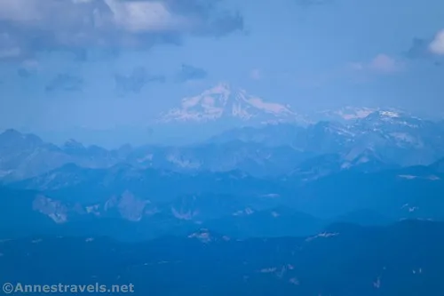
Time was getting on, and we’d left part of our party on the Climbers Trail (he’s not thrilled with steep trails in general, and steep scree-trails are some of the worst), so it seemed prudent to make our way back down all those awful scree slopes well before sunset. As we hiked back down, we could see north to Mt. Baker.
It turns out that the rangers had passed him (and were quite surprised to see anyone on the trail). Yes, they knew all about the old road – one of the more senior rangers is apt to take new seasonal rangers up there in hopes of one day making it into a real trail. Wow – we took a trail before it became a trail!
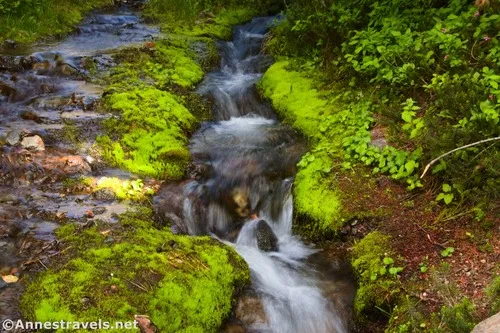
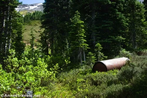
The trail becomes slightly easier as it descends, but it’s still steep and with some amount of scree. About 0.4 miles from the ridgeline, we went over to an old mine area (they mined copper up here) in the middle of a sea of brilliantly green moss. Very cool!
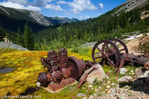
There were quite a few historical relics along the stream that tumbled down the mountain. I gather that there was a power plant and a sawmill, among other conveniences and necessities. Social trails led down to the streambed of the Inter Fork. Cross the stream (I made it with dry feet due to strategic use of my trekking poles, but then fell backward while helping another group member across – the rocks are hard, lol, and he still got wet feet!). Locate the trail that scrambles up the bank (it’s pretty obvious and well-trodden) and take the short distance up to the Glacier Basin Trail.
At this point, you have a choice. You can turn left and explore Glacier Basin (we didn’t have time or energy for that, so we ended up hiking back up here the next day) or you can turn right to almost immediately pass through Glacier Basin Camp. Beyond the camp is a trail on the left to a mountain toilet (much further off of the main trail that you’d think – about a tenth of a mile each way). From there, the trail descends back down to the Emmons Moraine Trail Junction and then back to the parking area, passing a trail up to Burroughs Mountain “Sunrise Trail” about 0.8 miles below Glacier Basin Camp.
And that’s a wrap! The views are well worth the effort, even though the effort is extreme. If you do the trail, let me know in a comment or on social media – I expect you’ll be one of the few!
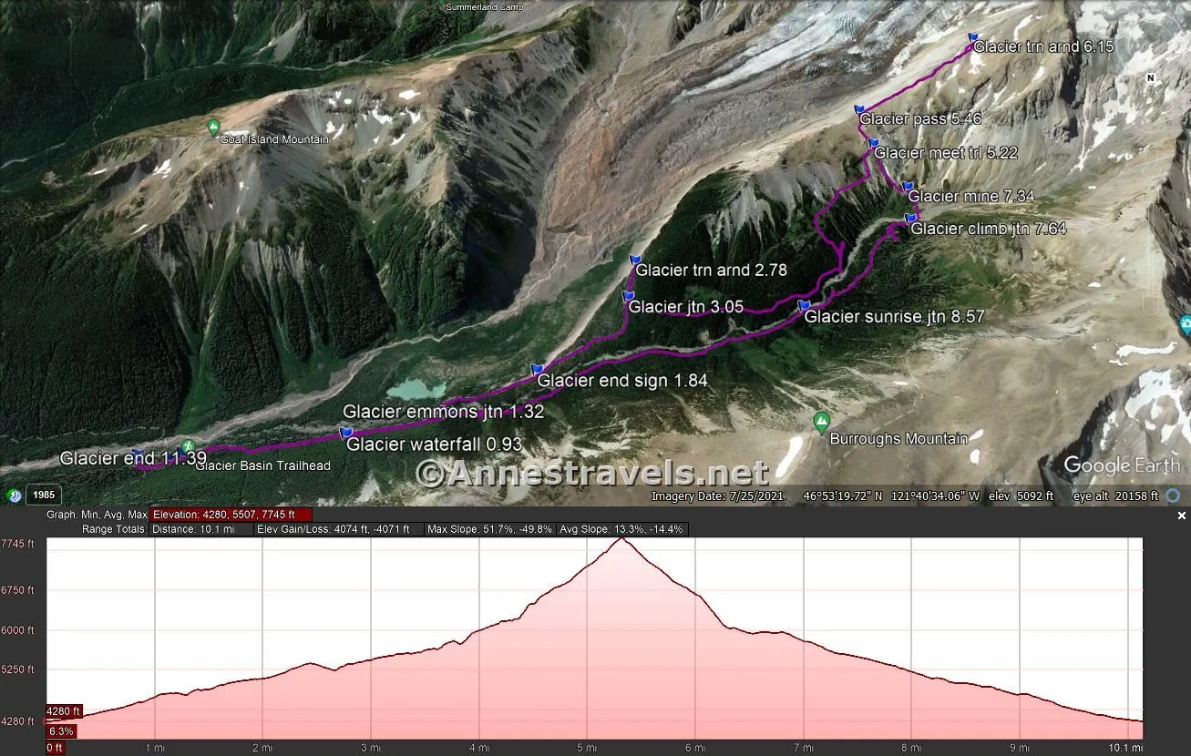
Round Trip Trail Length: I went 11.4 miles. If you take the Glacier Basin Trail instead of the old road, you can shave off 1.3-ish miles (it’s all relative).
Elevation Gain: 4,074ft. (4,280ft. to 7,745ft.) (3,843ft. if you take the Glacier Basin Trail instead of the old road)
Facilities: Restrooms, water, trash, picnicking, and camping at the trailhead. Mountain toilet at Glacier Basin Camp (don’t gag)
Fees: $30/vehicle, valid 7 days. America the Beautiful National Parks & Federal Lands Passes are accepted. Between July and early September, timed entry reservations are required between the hours of 7am and 3pm. Without a $2 timed entry ticket (not covered by a park pass), you will not be able to enter the corridor or reach the White River Campground (unless you happen to be already signed into a campsite at the campground) during these hours. Reserve your ticket here. (There’s a reason I get up early!) Also note that the Sunrise corridor (at least to the campground) may still be snowbound throughout the month of May; the higher area of the road may not open until early July. It closes in the mid-fall.
Trail Notes: This route requires significant off-trail travel. Do not attempt if you aren’t very used to following invisible trails, hiking on scree, etc. It’s also insanely steep at times. Remember to Leave No Trace, especially when you’re hiking beyond the “Trail Not Maintained” signs. The route may be snowed in until late June or early July. The old road was part of mining operations searching for copper in Glacier Basin (mostly) in the first half of the 1900s (I gather it tangentially continued until 1984). You’re allowed to go to 10,000ft. without any special permits; beyond this, you’ll need a Cascade Volcano Pass I turned around about 7,700ft. for reference).
Trail 
![]()
![]()
![]()
Road ![]()
Signs ![]()
![]()
Scenery
Would I go 100 miles out of my way for this?
Overall Rating: ![]()
GPS Coordinates for Emmons Moraine Trail to the Old Road to the Climber’s Trail & Back via Glacier Basin Trail
TH (near trash cans): 46.9017650°, -121.6426230° (46°54.10590′, -121°38.55738′ / 46°54’06.3540″, -121°38’33.4428″) (4,280ft.) (0.0)
2nd Restroom (cutoff trail): 46.9019540°, -121.6449980° (46°54.11724′, -121°38.69988′ / 46°54’07.0344″, -121°38’41.9928″) (4,314ft.) (0.14)
Glacier Basin TH: 46.9017110°, -121.6459250° (46°54.10266′, -121°38.75550′ / 46°54’06.1596″, -121°38’45.3300″) (4,325ft.) (0.19)
Waterfall: 46.9011310°, -121.6580170° (46°54.06786′, -121°39.48102′ / 46°54’04.0716″, -121°39’28.8612″) (4,641ft.) (0.93)
Emmons Moraine Trail Junction: 46.9001260°, -121.6653180° (46°54.00756′, -121°39.91908′ / 46°54’00.4536″, -121°39’55.1448″) (4,814ft.) (1.32)
“End of Maintained Trail” Sign: 46.8977210°, -121.6718050° (46°53.86326′, -121°40.30830′ / 46°53’51.7956″, -121°40’18.4980″) (5,011ft.) (1.84 Note – all mileages beyond this are 0.7-0.8 miles off due to getting off the trail)
Turn around (end of trail): 46.8906180°, -121.6794350° (46°53.43708′, -121°40.76610′ / 46°53’26.2248″, -121°40’45.9660″) (5,367ft.) (2.78)
Old road junction: 46.8931140°, -121.6787990° (46°53.58684′, -121°40.72794′ / 46°53’35.2104″, -121°40’43.6764″) (5,241ft.) (3.05)
Drop into Inlet Fork streambed: 46.8918520°, -121.6958720° (46°53.51112′, -121°41.75232′ / 46°53’30.6672″, -121°41’45.1392″) (5,640ft.) 4.57)
Meet Climber’s Trail: 46.8839080°, -121.6999370° (46°53.03448′, -121°41.99622′ / 46°53’02.0688″, -121°41’59.7732″) (6,507ft.) (5.22)
Top of Ridge: 46.8815690°, -121.6991260° (46°52.89414′, -121°41.94756′ / 46°52’53.6484″, -121°41’56.8536″) (6,811ft.) (5.46)
Turn around: 46.8777350°, -121.7095310° (46°52.66410′, -121°42.57186′ / 46°52’39.8460″, -121°42’34.3116″) (7,747ft.) (6.15)
Mine: 46.8863410°, -121.7024700° (46°53.18046′, -121°42.14820′ / 46°53’10.8276″, -121°42’08.8920″) (6,043ft.) (7.34)
Climber’s Trail Junction: 46.8888140°, -121.7020160° (46°53.32884′, -121°42.12096′ / 46°53’19.7304″, -121°42’07.2576″) (5,955ft.) (7.64)
Sunrise (Burroughs Mountain) Junction: 46.8944770°, -121.6923720° (46°53.66862′, -121°41.54232′ / 46°53’40.1172″, -121°41’32.5392″) (5,523ft.) (8.57)
End (near trash cans): 46.9020010°, -121.6426200° (46°54.12006′, -121°38.55720′ / 46°54’07.2036″, -121°38’33.4320″) (4,283ft.) (11.39)
The gpx file for Emmons Glacier Overlooks via the Old Road & Climber’s Trail can be downloaded – please note that this and the GPS Coordinates are for reference only and should not be used as a sole resource when hiking this trail.
Download GPX File size: 62.0 KB Downloaded 56 times
(Note: I do my best to ensure that all downloads, the webpage, etc. are virus-free and accurate; however, I cannot be held responsible for any damage that might result, including but not limited to loss of data, damages to hardware, harm to users, from use of files, information, etc. from this website. Thanks!)
Getting to the Glacier Basin Trailhead
If you’re staying in the campground, you can simply walk to the trailhead. However, for those coming in from outside, here are some directions:
From the Sunrise Entrance Station (1.3 miles off of WA-410), continue on the main park road. When the Sunrise Road diverges into a switchback after 4.0 miles (just after crossing the White River), bear left to continue toward the White River Campground. After 1.3 miles, turn left into the parking area (I believe it’s signed for backpackers or overnight hikers, but it’s actually also for day hikers).
Today’s Featured Product!
A few years ago, I wrote a guide to my favorite scenery in Washington. It covers multiple parks but only takes you to the very best scenery the state has to offer. Buy your copy here!


Pingback: 118 Miles on the Pacific Coast, Mount Hood, and Mount Rainier! – Anne's Travels