
Piute Pass was one of my favorite trails in the High Sierra. (A few of the other contenders were Saddlebag Lake (20 Lakes Basin), Kearsarge Pass, and San Joaquin Mountain.) The sheer beauty along the path up to the saddle blew my mind. The pass had fantastic views, too. Then we hiked up above the pass, and that was even better!
Quick Stats
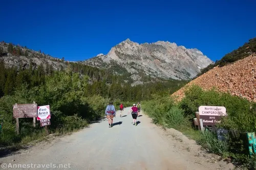
The trail doesn’t begin at the trailhead. Unless you’ve snagged a campsite at the campground at the trailhead, you’ll need to park in the hiker’s parking area along the road about 0.4 miles below the campground. It’s well-signed – at least, it’s well-signed that you can’t go further up the road; the turnoff for the hiker’s parking area is behind some bushes. Hike back down the access road (about a tenth of a mile) for the hiker’s parking, and turn right on the main road. It passes through some meadows and then ascends through the trees to the campground. At the signboards (mile 0.5 from the parking area), turn right; at the trailhead signboards (mile 0.55), continue straight toward the vault toilet. Stay to the right of the restrooms, take the right fork of the trail toward Piute Pass, and you’ll be on the trail!
I found the road-to-treeline portion of the hike to be insanely full of mosquitos. It seems that the bugs have a certain line at which they live – and above or below that line, there aren’t any. The line at which the mosquitos feast changes throughout the season. But on a typical first week of July, the bug line seemed to be between 7,000ft. and 9,000ft… more or less!
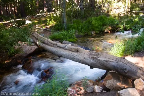
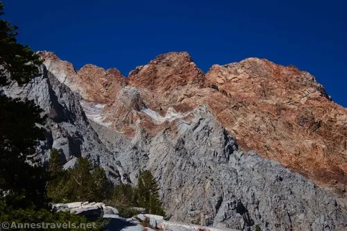
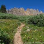
Pass by the trail to Lamarck Lake on the left, then enter the John Muir Wilderness at mile 0.55. Continue uphill to where the trail crosses the stream. This is a little confusing, but if you head upstream, there is a log that’s fairly easy to cross. The trail continues uphill through the trees to cross over the creek again on a flatter – if much worse condition – log bridge. After this, the trail begins to break out of the trees – at least, you get increasingly better peek-a-boo views through the trees to cliffs and rock formations high above the valley.
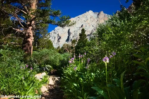
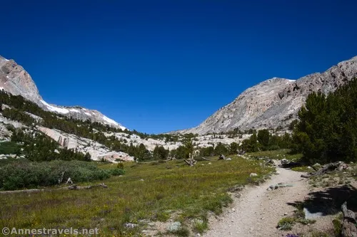
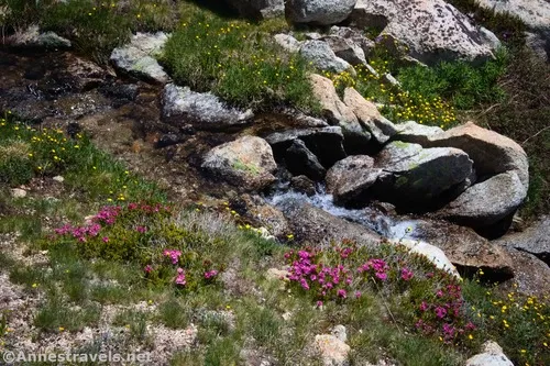
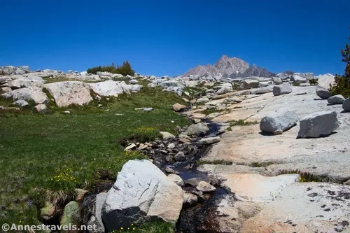
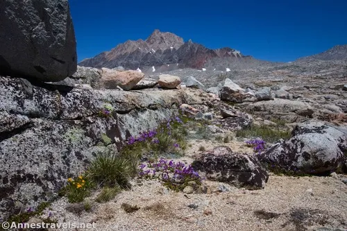
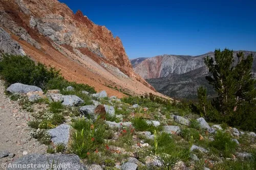
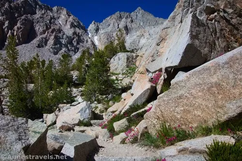
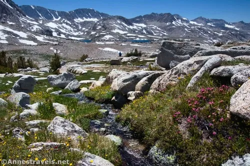
At last, the trail breaks out of the forest into a land of rocks, stunted trees, and so many cliffs! Keep your eyes open for waterfalls and wildflowers.
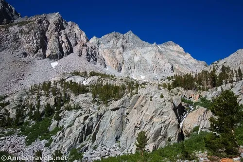
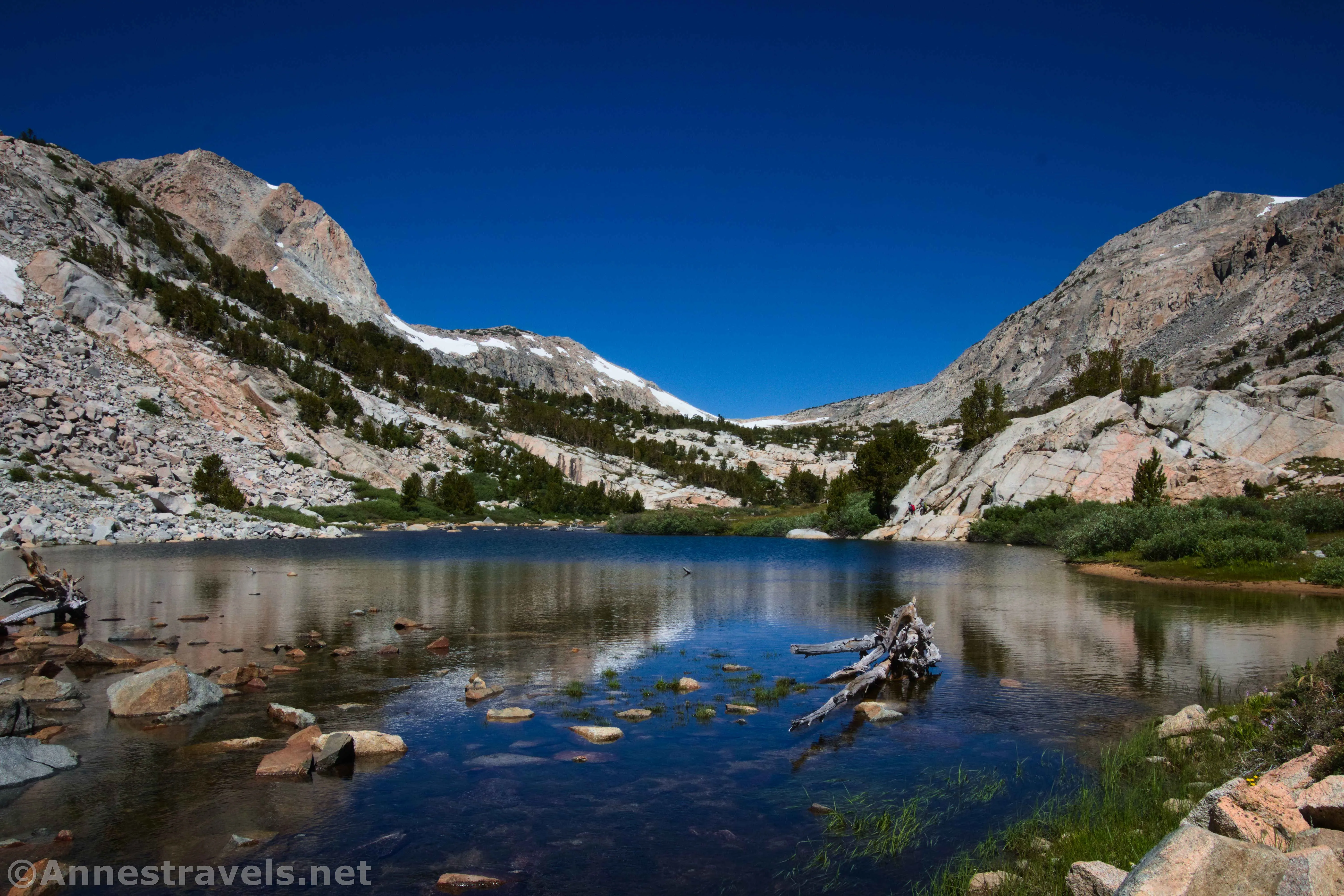
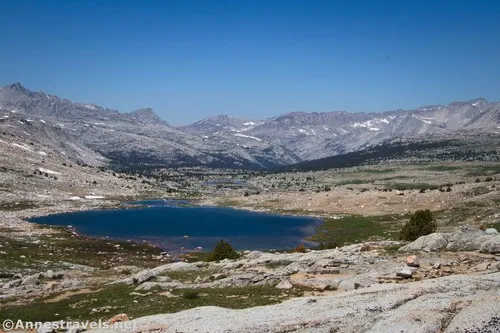
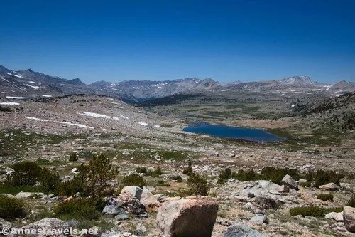
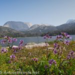
The path continues to be in good condition as it rises up to the first lake (Loch Leven) at mile 3.0. I saw a few campsites as I continued higher.
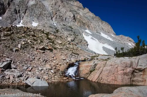
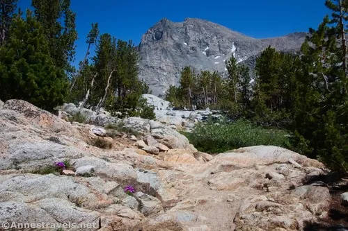
The meadows above Loch Leven are lovely, as is a waterfall or two.
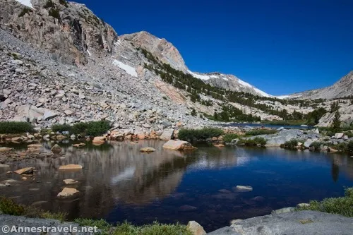
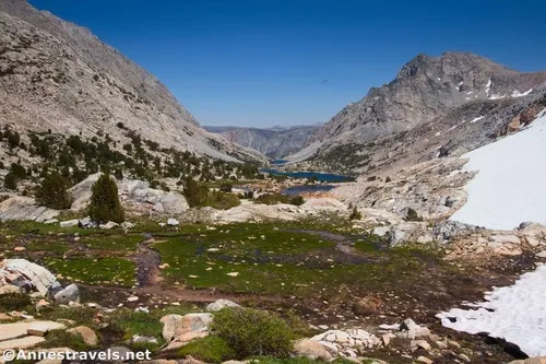
The trail continues to climb through meadows and past lakes (most notably Piute Lake at mile 3.7). Above Piute Lake, lingering snowfields made for a fun (interesting?) little diversion, but they weren’t difficult to cross. The snow had left a lot of water in the meadows up here!
Be sure to look back from this area – the views down the valley to Loch Leven and Piute Lake are stunning! Plus, it shows you just how far you’ve come… and how far you’ll have to go back downhill.
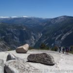
And then – finally! – 5.4 miles from the trailhead – the trail crests Piute Pass. I don’t recall much in the way of a sign marking the pass, but it’s pretty obvious since the trail starts down immediately into Humphreys Basin. You’re also crossing from Inyo National Forest into Sierra National Forest at this point.
I’d read from reliable sources that Humphreys Basin is a fabulous place to camp with great views. However, I decided the views were quite nice from the pass, and I felt no need to go down just to up again.
That feeling lasted until after lunch, when I decided to explore both sides of Piute Pass. Some hikers I had met raved about the southern side, but the north side looked more like my kind of scenery. So I headed north first, mostly following a stream so that I wouldn’t have to trample the meadows and wildflowers.
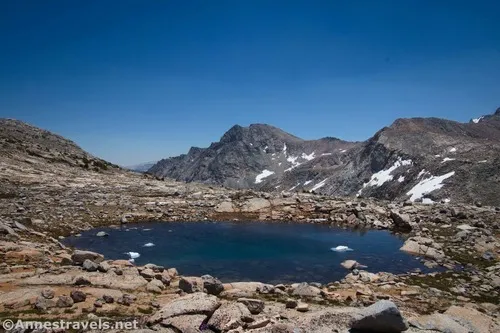
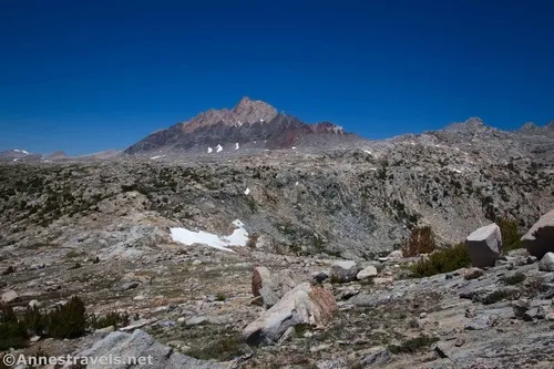
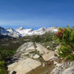
The higher we climbed, the more Mount Humphreys dominated the northern view. It’s quite impressive, so we kept climbing up to a plateau area above the pass.
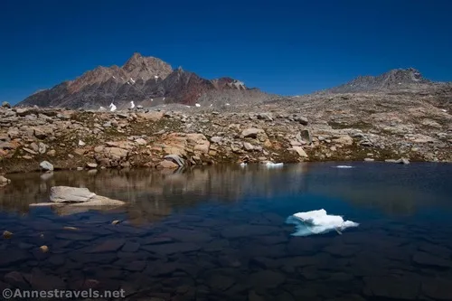
At the plateau, about half a mile above the pass, we discovered a lake that still had icebergs. (In fact, one of the icebergs broke apart and sank as we were balancing atop a rocky knoll taking far too many photos.)
But the real attraction was Mount Humphreys and the surrounding views, especially down into Humphreys Basin. Just wow!!
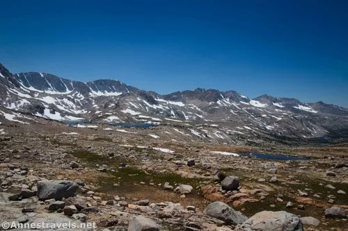
Time was getting on, so we went back down the stream (more or less) to Piute Pass and up the southern side. We didn’t go too far (only about a quarter mile), but views were definitely good down on Humphreys Basin.
The southern side is a little easier to climb (more people do it, probably) but I’d say the views were better from the north side of the pass. But that’s just my opinion, possibly swayed because I love little streams and wildflowers so much – and the north side definitely took the prize for that kind of scenery!
And then it was a hop-to back to the pass and down the valley to the trailhead. It was a very long day, but oh, what views! I’d totally do it again if I happened to be in the neighborhood!
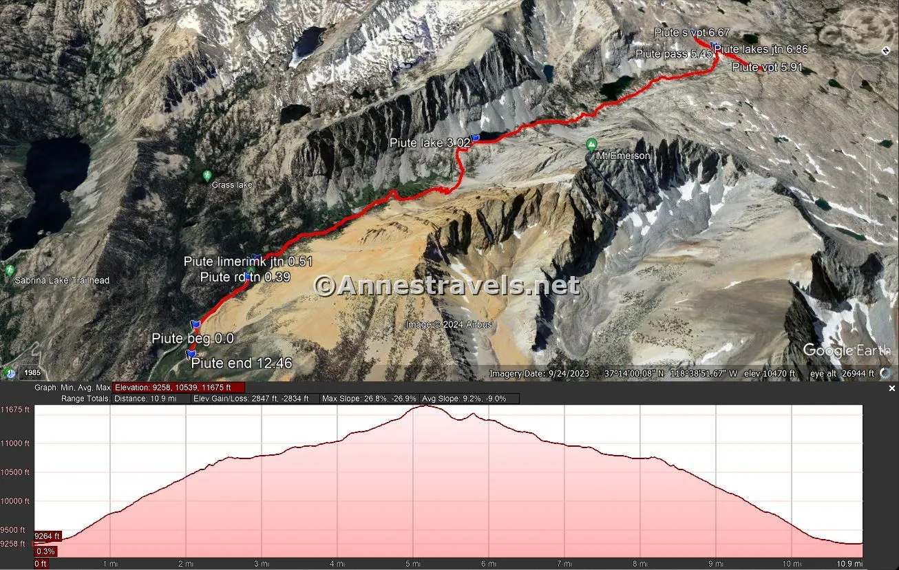
Round Trip Trail Length: I went 12.5 miles. Without the two side-treks up the sides of Piute Pass, it would be closer to 10.9 miles.
Elevation Gain: 2,847ft. (9,258ft. to 11,675ft.) (Just Piute Pass is 2,462ft. (9,247ft. to 11,415ft.))
Facilities: Vault toilets in the campground
Fees: None for day use; overnight use requires a permit (I believe it’s $5/person/night+$6/trip)
Trail Notes: Most of the people I met were on overnight trips to Humphreys Basin and beyond. Don’t underestimate this trail; when it goes up, it does so forever! That said, the trail is generally in good condition. I believe the current fee for the campground is around $30 – pretty steep for a campsite with no water IMO, but also quite convenient. Be watchful for summer afternoon thunderstorms – there’s not much in the way of shelter above Piute Lake.
Trail 
![]()
![]()
![]()
Road ![]()
Signs ![]()
Scenery
Would I go 100 miles out of my way for this?
Overall Rating: ![]()
GPS Coordinates for Piute Pass
Beginning (actually the turnoff for the hiker parking): 37.2287520°, -118.6206090° (37°13.72512′, -118°37.23654′ / 37°13’43.5072″, -118°37’14.1924″) (9,283ft.) (0.0)
Turn right at the campground road: 37.2277410°, -118.6272180° (37°13.66446′, -118°37.63308′ / 37°13’39.8676″, -118°37’37.9848″) (9,345ft.) (0.39)
Trailhead: 37.2273750°, -118.6275220° (37°13.64250′, -118°37.65132′ / 37°13’38.5500″, -118°37’39.0792″) (9,356ft.) (0.42)
Lamarck Lake Junction: 37.2266590°, -118.6285050° (37°13.59954′, -118°37.71030′ / 37°13’35.9724″, -118°37’42.6180″) (9,382ft.) (0.51)
Enter wilderness: 37.2266990°, -118.6291390° (37°13.60194′, -118°37.74834′ / 37°13’36.1164″, -118°37’44.9004″) (9,404ft.) (0.55)
Loch Leven: 37.2312940°, -118.6539700° (37°13.87764′, -118°39.23820′ / 37°13’52.6584″, -118°39’14.2920″) (10,749ft.) (3.02)
Piute Lake: 37.2360370°, -118.6684640° (37°14.16222′, -118°40.10784′ / 37°14’09.7332″, -118°40’06.4704″) (10,967ft.) (3.7)
Piute Pass: 37.2390100°, -118.6842470° (37°14.34060′, -118°41.05482′ / 37°14’20.4360″, -118°41’03.2892″) (11,417ft.) (5.45)
Northern viewpoint: 37.2444400°, -118.6840920° (37°14.66640′, -118°41.04552′ / 37°14’39.9840″, -118°41’02.7312″) (11,652ft.) (5.91)
Southern viewpoint: 37.2363940°, -118.6843480° (37°14.18364′, -118°41.06088′ / 37°14’11.0184″, -118°41’03.6528″) (11,537ft.) (6.67)
Piute Canyon Trail/Muriel Lake Trail Junction: 37.2386480°, -118.6843850° (37°14.31888′, -118°41.06310′ / 37°14’19.1328″, -118°41’03.7860″) (11,417ft.) (6.86)
End (hiker parking area): 37.2308220°, -118.6186310° (37°13.84932′, -118°37.11786′ / 37°13’50.9592″, -118°37’07.0716″) (9,281ft.) (12.46)
The gpx file for the Piute Pass Trail can be downloaded – please note that this and the GPS Coordinates are for reference only and should not be used as a sole resource when hiking this trail.
Download GPX File size: 162.4 KB Downloaded 322 times
(Note: I do my best to ensure that all downloads, the webpage, etc. are virus-free and accurate; however, I cannot be held responsible for any damage that might result, including but not limited to loss of data, damages to hardware, harm to users, from use of files, information, etc. from this website. Thanks!)
Getting to the Piute Pass Trailhead
From downtown Bishop, California, turn onto CA-168, which heads due west toward the mountains. After 18.0 miles, turn right onto N Lake Road (it’s right next to an overnight parking area and immediately crosses a creek via a bridge before turning to dirt with occasional paved sections). Drive 1.6 miles; turn right, following the signs for the hiker parking area.
Today’s Featured Product!
With more than 105 hikes to choose from, it should be easy to find some truly awesome hikes in the Sierra with this book. It stretches from Giant Sequoia National Monument all of the way up to considerably north of Lake Tahoe. Buy your copy here!


Pingback: 81 Miles in the High Sierras! – Anne's Travels