Overshadowed by its near neighbors Mt. Rushmore National Monument, Crazy Horse Memorial, and all of the commercializing that goes with those monuments, Custer State Park isn’t as well known as it probably deserves. Still, it’s near enough to these monuments that it gets quite a few visitors. Most come to fish or swim in its lakes, climb Harney Peak which proudly holds the title of highest mountain west of the Rockies and east of the Pyrenees, enjoy the park’s abundant wildlife including its herds of bison (American buffalo) and pronghorn, or just to drive the famous Iron Mountain Road with its pigtail curves and tunnels that frame Mt. Rushmore. I recommend all of these (especially the Iron Mountain Road), but an often over-looked attraction is Sylvan Lake in the northwest part of the park.
Actually, the Sylvan Lake parking area is a popular place to park when climbing Harney Peak. The parking area is also popular with anglers and picnickers who come to enjoy the shaded picnic area on the east side of the lake. So, on a summer weekend, there may not be many (if any) parking spaces left unless you get there early. Still, morning is the best time to see the lake, so it’s not bad to get an early start.
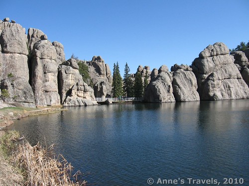
The trail starts in the parking area, or you can start from the lodge. We went clockwise around the lake, which in the morning is the best way to go, because of the direction that the sun is shining. It also kept us away from the crowds who went to the picnic area and turned around. The hard-packed gravel/sand trail is quite flat on the west side of the lake, and is probably wheel-chair accessible. This side also offers some really stunning views across the blue water, with the huge boulders at the end of the lake. It makes for some great pictures. We meandered our way along this side of the lake until we got to the boulders at the far end and discovered that this is not a natural lake, as we had supposed; the “bridge” at the end is actually the top of a concrete dam! Although it was a little bit of a disappointment, we were able to step out onto the dam and get a different view of the lake, as well as down the other side of the dam to the forest below. I wouldn’t recommend doing this to anyone who was afraid of heights (the one side is level with the lake, and the other is a good 20 to 30 ft. drop) or who didn’t want to get their feet wet (we had to step in the water a little to get to the top of the dam), but we found it fascinating.
From here, most people turn around, and unfortunately it’s not wheelchair accessible beyond this point. However, there is a little trail that goes down between two of the boulders. It is a tight space, almost like a cave or a slot canyon, but is very doable, and the walking isn’t hard. On the other side we were many feet below the lake’s surface, and by going right (following the trail) we were at the base of the dam. I recall it being chilly down here out of the sun on a morning in May, so it might be a good place to hang out in the summer.
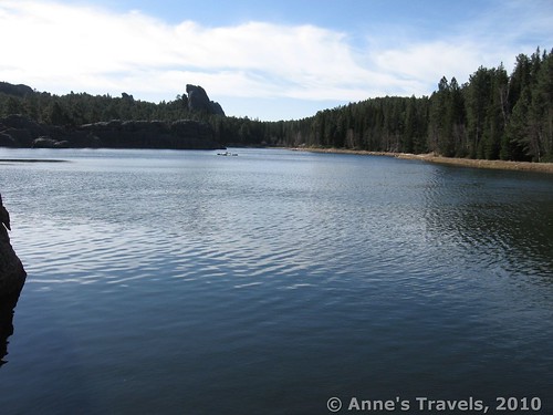
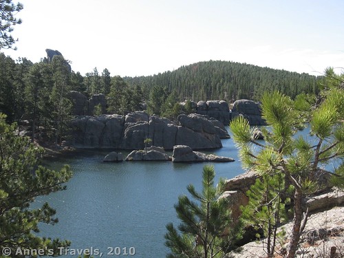
Keep following the trail around the boulders at the end of the lake (which is now out of site). The trail here was very wet, and we soon discovered why. Way back in a fisher of the rock was a waterfall from the lake. It was a very pretty waterfall, even if it was a little hard to see. It also answered our question of how the lake drains its water, since we knew there was a stream feeding the lake, and we didn’t see any water going over the dam. The trail then begins a very steep, rocky uphill climb. It is obviously the least-used part of the trail, as well as the least-maintained. But, when you finally get to the top, you will be rewarded with views of the lake at a different angle than before. If you want to avoid this section of trail, go back the way you came, and then take the trail from the picnic area. You’ll eventually come out on the top of the hill. However, if you decide to climb the hill, keep following the trail past different viewpoints over the lake. The trail will curve to follow the lakeshore, mostly staying in the pine forest on this side of the lake (the other side had an amazing lack of trees). Our best pictures of the lake came from this side, about halfway down the lake (see the picture at the top of this post). We’ve used those pictures for all kind so things, from calendar pictures to facebook profile pictures. I even used it in a school group-assignment. The teacher and the classmates were really impressed with it, and we ended up making it the signature picture of the event we were planning. Not bad for a picture taken two years earlier!
From here the trail turns away from the lakeshore, goes through a stand of rocks and boulders, through the picnic area, and back to the parking area. We stopped to play on the rocks, and we hadn’t exactly hurried our hike, so it took us most of the morning to walk all the way around. It was a nice leisurely stroll, and something that most families could probably do at least part of. Not exactly a wilderness hike, but something a little more doable for those who aren’t used to hiking, but who want nice scenery. This is Custer at its best!
Trail 


Road 


Signs 


Scenery 


Overall Rating: 


This Week’s Featured Product!
Check out the Black Hills and more hiking in this guide!




Pingback: Celebrating 20 Years of Family Vacation - Anne's Travels