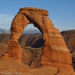
If there’s a scene in Arches National Park that’s totally classic (other than Delicate Arch!) it’s the view of the North and South Windows. At sunrise, you’ll often find photographers lining up to get iconic shots of both or either of the Windows and/or Turret Arch. Right across the parking lot is the short path to Double Arch. Even if you’re not a photographer, the short trails are incredibly scenic. So all of that to say that the Windows are a must-stop hike if you love photography or just want to see the arches for yourself!
Quick Stats
The trail isn’t terribly long, so it’s a favorite with tourists and tour bus occupants alike. However, on an afternoon in mid-November, I didn’t find it to be all that crowded. (COVID might have helped with that – it’s the first time I’ve visited where I haven’t seen tour busses – but the time of year also meant fewer tourists.) I didn’t even have to wait for a parking space, which has not always been the case in other seasons.

I decided to hike the Windows Loop backward, starting on the Primitive Loop, walking behind the North and South Windows, and then looping back around to the front of the arches. I did not go over to Turret Arch on this trip (I’ve done that more than a few times before), nor did I go to Double Arch. But on a previous trip, I did Double Arch and got some great photos, so I’ll include trail info for that hike at the bottom of this post.

The Primitive Loop begins to the left (north) of the main trailhead. It’s a very obvious trail even if it isn’t terribly well-marked. As you hike up the sandy path, look over to the right to see Seagull Arch – the fin with Seagull Arch is keeping you from seeing the North Window from this vantage point.

Keep hiking as the path turns south and scrambles up some rocks between two sandstone towers. Look to the east and you’ll see the La Sal Mountains and the cliffs beyond the Colorado River. It’s spectacular, though I’d guess the views were even better because it was afternoon.

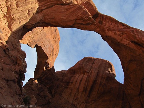
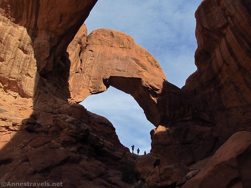
The trail then winds its way behind a sandstone wall and, eventually, behind the North and South Windows. It was totally the wrong time of day for this part of the hike, as the sun was directly behind the Windows. Oh well.

The path quickly takes you around in what amounts to a U-turn to the front of the South Window. This is the end of the Primitive Loop and so you’re on to the main trail from now on.

The views of the South Window are excellent. It’s hard to get a sense of scale, but I did my best with the photos.

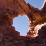
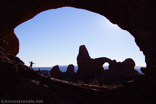
Continuing on the trail back toward the parking area, you can get some good views of Turret Arch. Afternoon is totally the wrong time of day to be looking at it from this angle, but I took a few pictures anyway.

At the trail junction, turn toward North Window (you can also do a spur over to Turret Arch if you want to). The path rises up to the Window.

I scrambled all of the way through and then scrambled up some rocks to frame Turret Arch through the North Window. The sun was in the wrong place for the classic shot, but hey, we made it work!
Scramble back down and head back for the parking lot (or Turret Arch, if you want to, on the way). There are quite a few steps; be sure to look over to the right to see the south side of Seagull Arch.

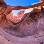
Once back in the parking lot, take the trail that crosses the median between the two levels of the parking area. Cross the lower portion of the parking loop and locate the trailhead for Double Arch (it’s not hard to spot). Take the well-established path as it heads for the cove where the arches are. I hiked Double Arch early in the morning in May some years ago, and as you can see, it’s somewhat shadowed in the early morning.

As you get closer, you can start to get a perspective on the sheer immensity of the arches. The trail is sandy but totally hikable as it crosses the desert and a few small washes.

Most people stop underneath the first arch (it’s really impressive!) Several of us scrambled up on the rocks (be careful – I scraped my shins proper when I slipped on these rocks on my first visit in 1997) and even up into the second arch.
From up here, there are some nice views out into the Cove of Caves (behind the arch) and also back to the North Window (better from the trail) and the La Sal Mountains.

Overall, the entire Windows Loop is 1.3 miles and the trail to Double Arch is a total of 0.5 miles. Both are fairly easy hiking with only a little scrambling on the Primitive section of the Windows Loop. So if you have a chance, check them out – you won’t be disappointed!

Total Trail Length: 1.3 miles for the Windows Loop, 0.5 miles for Double Arch
Elevation Gain: 205ft. (5,174ft. to 5,272ft.) for the Windows Loop, 192ft. (5,120ft. to 5,252ft.) for Double Arch
Facilities: Primitive restrooms; there may also be water
Fees: $30/vehicle, valid 7 days. America the Beautiful passes also accepted.

Trail Notes: Be sure to arrive early or in an off-time of the year to get a parking space (a pilot program has been introduced to help reduce crowds; we shall see how that goes). Most of the views are best in the morning (at least for the classic shots), but afternoon is nice, too, especially for the front sides of the Windows.
Trail 
![]()
Road ![]()
Signs
Scenery
Would I go 100 miles out of my way for this?
Overall Rating: 

GPS Coordinates for the Windows Loop
Arches Primitive Loop TH: 38.6875000°, -109.5364667° (N38° 41.250′ W109° 32.188′ / 38°41’15.0000″, -109°32’11.2800″) (5,131ft.) (0.0)
South Window: 38.6848667°, -109.5324333° (N38° 41.092′ W109° 31.946′ / 38°41’05.5200″, -109°31’56.7600″) (5,181ft.) (0.7)
South Window Overlook: 38.6843833°, -109.5326667° (N38° 41.063′ W109° 31.960′ / 38°41’03.7800″, -109°31’57.6000″) (5,205ft.) (0.8)
North Window: 38.6857000°, -109.5328167° (N38° 41.142′ W109° 31.969′ / 38°41’08.5200″, -109°31’58.1400″) (5,238ft.) (1.0)
Trail Junction: 38.6860167°, -109.5350833° (N38° 41.161′ W109° 32.105′ / 38°41’09.6600″, -109°32’06.3000″) (5,154ft.) (1.2)
End: 38.6871167°, -109.5366667° (N38° 41.227′ W109° 32.200′ / 38°41’13.6200″, -109°32’12.0000″) (5,133ft.) (1.3)

GPS Coordinates for Double Arch
Double Arch Trailhead: 38.6883000, -109.5383667 (38°41.29800′, -109°32.30200′ / 38°41’17.8800″, -109°32’18.1201″)
Double Arch: 38.691496, -109.540188 (38°41.48976′, -109°32.41128′ / 38°41’29.3856″, -109°32’24.6768″)

The gpx file for the Windows Loop and for Double Arch can be downloaded – please note that this and the GPS Coordinates are for reference only and should not be used as a sole resource when hiking this trail.
Windows Loop:
Download GPX File size: Invalid download ID. Downloaded 357 times
Double Arch:
Download GPX File size: 4.5 KB Downloaded 355 times
(Note: I do my best to ensure that all downloads, the webpage, etc. are virus-free and accurate; however, I cannot be held responsible for any damage that might result, including but not limited to loss of data, damages to hardware, harm to users, from use of files, information, etc. from this website. Thanks!)

Getting to The Windows and Double Arch
From the visitor center, continue into the park for 9.1 miles. Turn right, following signs for Windows. Park at the end of the road about 2 miles later. Note that the parking area can be very full; I recommend hiking here in the early morning or evening or, preferably, from November-March.

This Week’s Featured Product!
This may well be one of the most comprehensive books about hiking in Arches National Park. With close to 25 trails, the book covers just about everything you’ll need to know to go hiking in Arches.