

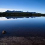
Yellowstone Lake Overlook at West Thumb is possibly the best viewpoint I’ve found of Yellowstone Lake. (The other contenders are Elephant Back Mountain (too many trees), Storm Point and Gull Point (very nice but on level with the lake), an unnamed trail near a picnic area somewhere between West Thumb and Fishing Bridge, and Lake Butte Overlook (very different angle).) The vistas from the overlook are sweeping and include so many mountains, hills, forests, and more. Plus, the trail begins from the same parking area as the West Thumb Geyser Basin, so you can see those fantastic views, as well, before or after you hike up to the official Yellowstone Lake Overlook!
Quick Stats

The trailhead is well-marked, but it’s tucked away on the diagonally opposite side of the parking area from the West Thumb Geyser Basin Trail, so it’s not uncommon for it to be overlooked, even by those who are trying to find it. (I happened to park near the trailhead sign, and I pointed more than one group in the direction they wanted to go.) Basically, you want to have your back to the West Thumb Geyser Basin. Walk to the sidewalk by the furthest (south-most) line of parking spaces. Turn right almost until you run into the trees that separate the parking area from the entrance road. The sign for “Lake Overlook Trail” will be on your left (south) along with a wide but unassuming trail heading south into the trees. This is the trailhead.

After 0.3 miles, the trail crosses the main park road. Use extreme care here. There is a crosswalk, but not everyone knows about the “stop for pedestrians in a crosswalk” law in Wyoming, and it’s amazing how fast people drive through a national park.

Shortly after crossing the road, the trail splits just before a small meadow. I turned right across the bridge, and I’d probably do it that way again. I’d much rather climb up steeply than down steeply, and the right fork I felt was slightly steeper than the more gradual left option – so in other words, I hiked the loop counter-clockwise. (In reality, the right turn climbed more constantly while the left fork (return trail in my case) lost most of its elevation in one swoop, so it felt less steep overall.)

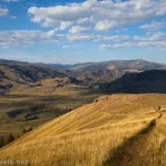
The path wanders uphill through the forest, then suddenly breaks out into meadows. As you rise through the meadows, be sure to look back – there are some truly fabulous views over Yellowstone Lake to the mountains beyond.

You’ll know you’ve arrived at the overlook (nearly a mile from the trailhead) when you see a bench (on the right) and a fence (on the left). The fence is to keep you from scrambling straight down the hill (there is a hot spring down there, and they probably don’t want anyone falling into it).

Views are expansive from here; more than 180 degrees. I especially appreciated the mountains across the lake (can you imagine what this would look like in spring, when the mountains are still snowy?).

When you’re done looking, continue down the other side (and it is down!). I found a garter snake and several wildflowers before reentering the forest.

Just before returning to the loop junction, a log with a hole in it provided a habitat for an orange mushroom.

Turn right at the loop junction, cross the road, and return to the trailhead at about mile 1.9. The elevation gain makes it harder than some hikes, but it still was an easy, beautiful stroll on an autumn afternoon.

Round Trip Trail Length: 1.9 miles
Elevation Gain: 291ft. (7,783ft. to 8,015ft.)
Facilities: Vault toilets and a couple of picnic tables at the West Thumb Geyser Basin Trailhead
Fees: $35/vehicle, valid 7 days. America the Beautiful National Parks & Federal Public Lands passes and Yellowstone Annual Passes are accepted.

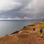
Trail Notes: This is a great little hike after (or before) hiking the geyser basin. The views from the geyser basin over Yellowstone Lake are also excellent, though it’s definitely a different vantage point since you’re more on par with lake level. The hillside is exposed, so don’t try it in a thunderstorm. Please stay on the trail as there is geothermal activity in the area (you don’t want to step into a hot spring, no matter how small it might be!)

Trail 
![]()
![]()
Road ![]()
Signs ![]()
Scenery
Would I go 100 miles out of my way for this? ![]()
Overall Rating: ![]()

GPS Coordinates for the Yellowstone Lake Overlook at West Thumb
TH: 44.4154160°, -110.5751750° (44°24.92496′, -110°34.51050′ / 44°24’55.4976″, -110°34’30.6300″) (7,792ft.) (0.0)
Cross road: 44.4133400°, -110.5779740° (44°24.80040′, -110°34.67844′ / 44°24’48.0240″, -110°34’40.7064″) (7,802ft.) (0.35)
Loop Junction: 44.4131500°, -110.5784510° (44°24.78900′, -110°34.70706′ / 44°24’47.3400″, -110°34’42.4236″) (7,803ft.) (0.37)
Overlook: 44.4120890°, -110.5865910° (44°24.72534′, -110°35.19546′ / 44°24’43.5204″, -110°35’11.7276″) (8,013ft.) (0.95)
End at TH: 44.4153910°, -110.5752010° (44°24.92346′, -110°34.51206′ / 44°24’55.4076″, -110°34’30.7236″) (7,792ft.) (1.90)

The gpx file for the Yellowstone Lake Overlook can be downloaded – please note that this and the GPS Coordinates are for reference only and should not be used as a sole resource when hiking this trail.
Download GPX File size: 32.0 KB Downloaded 83 times
(Note: I do my best to ensure that all downloads, the webpage, etc. are virus-free and accurate; however, I cannot be held responsible for any damage that might result, including but not limited to loss of data, damages to hardware, harm to users, from use of files, information, etc. from this website. Thanks!)

Getting to the Yellowstone Lake Overlook Trailhead
From the southern entrance station to Yellowstone National Park, continue north on the main park road for 21.2 miles to the junction near West Thumb. Turn right toward Fishing Bridge (and Canyon). After 0.2 miles, turn right into the access road for West Thumb Geyser Basin.

The left turn into the West Thumb parking area is 20.4 miles south of Fishing Bridge. Or from Old Faithful, drive south on the main park road for 17.6 miles; turn left toward Fishing Bridge (and Canyon) for 0.2 miles before turning right into the parking area for West Thumb Geyser Basin.


More Easy Hikes in Yellowstone
Explore more of the best easy day hikes in Yellowstone National Park with this guide. It covers 30 different trails to a variety of features, views, waterfalls, and more. Buy your copy here!


Pingback: How I Hiked 100 Miles in Yellowstone National Park in 11 Days – Anne's Travels